
Mt. Ōgi
扇ノ山
Wakasa, Tottori / Yazu, Tottori / Tottori, Tottori · Elevation 1,310 m
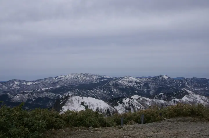
Ōginosen is a 1,310 m volcanic peak straddling the border of Tottori and Hyōgo Prefectures — its slopes lying within Tottori City, Wakasa Town and Yazu Town on the Tottori side and Shin'onsen Town on the Hyōgo side. The mountain takes its name from a profile said to resemble an opened folding fan; from its broad, beech-clad summit a 360-degree panorama opens onto Mt. Daisen and the Sea of Japan. A wooden refuge built in 1994 stands near the top, reached by several maintained routes including the Kawaidani-kōgen, Furusato-no-mori and Himeji courses. It lies within Hyōnosen-Ushiroyama-Nagisan Quasi-National Park and is listed in the Japanese 300 Famous Mountains, the Kansai 100, and the China-region 100, among others.
Mt. Ōgi at a glance
- Weather: The most settled day in the next 7 days is Wed, November 4: clear, gusts up to 10 m/s. Fri, Nov 6, Sat, Nov 7: strong wind (gusts up to 18 m/s).
- Route: The shortest is Mount Oginosen Out-and-Back via Ko-zukko and O-zukko on the Kawaitan Valley Trail: about 3 h 34 min, 6.5 km, about 380 m of climbing.
Mt. Ōgi weather (hourly, 14 days)
Sunrise today 06:25, sunset 17:07
| Tue, 11/3 | Wed, 11/4 | Thu, 11/5 | Fri, 11/6 | Sat, 11/7 | Sun, 11/8 | Mon, 11/9 | Tue, 11/10 | Wed, 11/11 | Thu, 11/12 | Fri, 11/13 | Sat, 11/14 | Sun, 11/15 | Mon, 11/16 | Tue, 11/17 | |||||||||||||||||||||||||||||||||||||||||||||||||||||||||||||||||||||||
|---|---|---|---|---|---|---|---|---|---|---|---|---|---|---|---|---|---|---|---|---|---|---|---|---|---|---|---|---|---|---|---|---|---|---|---|---|---|---|---|---|---|---|---|---|---|---|---|---|---|---|---|---|---|---|---|---|---|---|---|---|---|---|---|---|---|---|---|---|---|---|---|---|---|---|---|---|---|---|---|---|---|---|---|---|---|
| Japan time | 15 | 17 | 19 | 21 | 23 | 1 | 3 | 5 | 7 | 9 | 11 | 13 | 15 | 18 | 21 | 0 | 3 | 6 | 9 | 12 | 15 | 18 | 21 | 0 | 3 | 6 | 9 | 12 | 15 | 18 | 21 | 0 | 3 | 6 | 9 | 12 | 15 | 18 | 21 | 0 | 3 | 6 | 9 | 12 | 15 | 18 | 21 | 0 | 3 | 6 | 9 | 15 | 21 | 3 | 9 | 15 | 21 | 3 | 9 | 15 | 21 | 3 | 9 | 15 | 21 | 3 | 9 | 15 | 21 | 3 | 9 | 15 | 21 | 3 | 9 | 15 | 21 | 3 | 9 | 15 | 21 | 3 | 9 | 15 | |
  |   |   |   |   | | | |   |  | | | | | |   | | | |   | | |   | | | | |   | | | | | | | | | | | | | | | | |   | | | | | | | |   | | | | | | | | | | | | | | | | |  | | | | | | | | | | | | | | | ||
| Temperature | °C | 10° | 7° | 6° | 6° | 5° | 5° | 5° | 4° | 5° | 9° | 11° | 13° | 12° | 7° | 8° | 9° | 8° | 9° | 11° | 15° | 12° | 10° | 10° | 9° | 9° | 8° | 9° | 11° | 8° | 6° | 5° | 4° | 4° | 3° | 4° | 6° | 5° | 3° | 4° | 3° | 4° | 3° | 7° | 8° | 7° | 5° | 4° | 4° | 4° | 4° | 5° | 6° | 4° | 3° | 6° | 6° | 3° | 1° | 3° | 3° | 3° | 2° | 5° | 8° | 3° | 3° | 4° | 5° | 1° | 0° | 7° | 11° | 2° | 4° | 10° | 10° | 10° | 10° | 9° | 6° | 3° | 1° | 3° | 5° |
| Precipitation | mm | 0.2 | 0.1 | 0.2 | 0.1 | 2.4 | 0.9 | 3.0 | 0.9 | 6 | 1.5 | 0.6 | 1.0 | 1.7 | 1.1 | 0.6 | 0.6 | 0.5 | 0.3 | 0.1 | 0.8 | 0.8 | 0.7 | 0.3 | 0.3 | 2.1 | 4.9 | 1.4 | 0.1 | 3.1 | 2.6 | 2.9 | 1.2 | 1.5 | 0.5 | 3.3 | 4.7 | 0.3 | 1.3 | 9 | 7 | 6 | 8 | 4.6 | 0.1 | 0.2 | |||||||||||||||||||||||||||||||||||||||
| New snow | cm | ||||||||||||||||||||||||||||||||||||||||||||||||||||||||||||||||||||||||||||||||||||
| Snow depth | cm | 0 | 0 | 0 | 0 | 0 | 0 | 0 | 0 | 0 | 0 | 0 | 0 | 0 | 0 | 0 | 0 | 0 | 0 | 0 | 0 | 0 | 0 | 0 | 0 | 0 | 0 | 0 | 0 | 0 | 0 | 0 | 0 | 0 | 0 | 0 | 0 | 0 | 0 | 0 | 0 | 0 | 0 | 0 | 0 | 0 | 0 | 0 | 0 | 0 | 0 | 0 | 0 | 0 | 0 | 0 | 0 | 0 | 0 | 0 | 0 | 0 | 0 | 0 | 0 | 0 | 0 | 0 | 0 | 0 | 0 | 0 | 0 | 0 | 0 | 0 | 0 | 0 | 0 | 0 | 0 | 0 | 0 | 0 | 0 |
| Wind | m/s | 2 | 1 | 1 | 1 | 1 | 1 | 2 | 2 | 2 | 3 | 2 | 2 | 2 | 2 | 2 | 2 | 1 | 1 | 1 | 2 | 1 | 2 | 1 | 1 | 3 | 4 | 4 | 6 | 5 | 5 | 5 | 5 | 5 | 5 | 6 | 6 | 5 | 2 | 2 | 1 | 1 | 0 | 1 | 3 | 2 | 1 | 1 | 1 | 0 | 1 | 2 | 3 | 0 | 1 | 2 | 5 | 5 | 6 | 4 | 4 | 1 | 1 | 1 | 2 | 2 | 1 | 4 | 4 | 1 | 1 | 2 | 1 | 1 | 2 | 3 | 5 | 4 | 2 | 3 | 4 | 3 | 1 | 2 | 2 |
| Wind gusts | m/s | 8 | 7 | 5 | 5 | 4 | 4 | 6 | 6 | 7 | 9 | 10 | 8 | 8 | 7 | 7 | 7 | 6 | 6 | 4 | 6 | 6 | 6 | 6 | 8 | 10 | 14 | 13 | 18 | 18 | 15 | 15 | 16 | 15 | 16 | 16 | 18 | 17 | 14 | 8 | 8 | 6 | 5 | 5 | 10 | 10 | 7 | 4 | 4 | 5 | 5 | 7 | 10 | 9 | 4 | 8 | 16 | 16 | 19 | 17 | 13 | 10 | 4 | 4 | 7 | 10 | 8 | 11 | 12 | 11 | 5 | 8 | 7 | 6 | 7 | 9 | 16 | 20 | 15 | 11 | 13 | 14 | 10 | 7 | 8 |
| Wind dir. | ↓ | ↓ | ↓ | ↓ | ↓ | ↓ | ↓ | ↓ | ↓ | ↓ | ↓ | ↓ | ↓ | ↓ | ↓ | ↓ | ↓ | ↓ | ↓ | ↓ | ↓ | ↓ | ↓ | ↓ | ↓ | ↓ | ↓ | ↓ | ↓ | ↓ | ↓ | ↓ | ↓ | ↓ | ↓ | ↓ | ↓ | ↓ | ↓ | ↓ | ↓ | ↓ | ↓ | ↓ | ↓ | ↓ | ↓ | ↓ | ↓ | ↓ | ↓ | ↓ | ↓ | ↓ | ↓ | ↓ | ↓ | ↓ | ↓ | ↓ | ↓ | ↓ | ↓ | ↓ | ↓ | ↓ | ↓ | ↓ | ↓ | ↓ | ↓ | ↓ | ↓ | ↓ | ↓ | ↓ | ↓ | ↓ | ↓ | ↓ | ↓ | ↓ | ↓ | ↓ | |
Mt. Ōgi hiking routes
Hiking times are estimates calculated from the terrain.
Huts, campsites and lodging near Mt. Ōgi
Mountain huts
Campsites
- 八東ふる里の森 バンガロー
Lists that include Mt. Ōgi
Japan's 300 Famous Mountains · Kansai 100 Famous Mountains · Chugoku 100 Famous Mountains · Kinki 100 Famous Mountains · 100 Mountains of Our Home Hyogo · Elevations of 1003 Mountains of Japan · 1000 Mountains of Japan
Mt. Ōgi facts
- Elevation
- 1,310 m
- Location
- Wakasa, Tottori / Yazu, Tottori / Tottori, Tottori
35.439808, 134.440872 - National Park
- 氷ノ山後山那岐山国定公園
- Website
- www.torican.jp
- Trail Map
- www.torican.jp (PDF)
- Wikipedia
- ja.wikipedia.org