
Mt. Hachibuse
鉢伏山
Kami, Hyogo / Yabu, Hyogo · Elevation 1,222 m
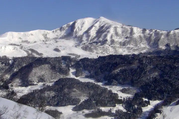
Hachibuseyama is a 1,221.6 m peak straddling Yabu City and Kami Town in Hyogo, set in the northern part of Hyōnosen-Ushiroyama-Nagisan Quasi-National Park. The summit is a shallow basin shaped like an upturned bowl—the source of the mountain's name—and the broad, gently rolling top supports susuki meadows together with prefecturally protected stands of Menyanthes trifoliata and Osmunda cinnamomea. The southern slope is the Hachi Kōgen ski area in Yabu, while the north side opens onto Hachi-kita Kōgen in Kami; the peak sits on the main ridge linking Hyōnosen and Torokawayama and is included in the Kansai 100 and Furusato Hyogo 100.
Mt. Hachibuse at a glance
- Weather: The most settled day in the next 7 days is Wed, November 4: clear, gusts up to 8 m/s. Fri, Nov 6, Sat, Nov 7: strong wind (gusts up to 18 m/s).
- Route: The shortest is Yabu Highland Circuit across Wide Burned Grassland over Mount Hachibuse and Mount Takamaru Facing Hyonosen: about 2 h 53 min, 5.8 km, about 400 m of climbing.
Mt. Hachibuse weather (hourly, 14 days)
Sunrise today 06:25, sunset 17:06
| Tue, 11/3 | Wed, 11/4 | Thu, 11/5 | Fri, 11/6 | Sat, 11/7 | Sun, 11/8 | Mon, 11/9 | Tue, 11/10 | Wed, 11/11 | Thu, 11/12 | Fri, 11/13 | Sat, 11/14 | Sun, 11/15 | Mon, 11/16 | Tue, 11/17 | |||||||||||||||||||||||||||||||||||||||||||||||||||||||||||||||||||||||
|---|---|---|---|---|---|---|---|---|---|---|---|---|---|---|---|---|---|---|---|---|---|---|---|---|---|---|---|---|---|---|---|---|---|---|---|---|---|---|---|---|---|---|---|---|---|---|---|---|---|---|---|---|---|---|---|---|---|---|---|---|---|---|---|---|---|---|---|---|---|---|---|---|---|---|---|---|---|---|---|---|---|---|---|---|---|
| Japan time | 15 | 17 | 19 | 21 | 23 | 1 | 3 | 5 | 7 | 9 | 11 | 13 | 15 | 18 | 21 | 0 | 3 | 6 | 9 | 12 | 15 | 18 | 21 | 0 | 3 | 6 | 9 | 12 | 15 | 18 | 21 | 0 | 3 | 6 | 9 | 12 | 15 | 18 | 21 | 0 | 3 | 6 | 9 | 12 | 15 | 18 | 21 | 0 | 3 | 6 | 9 | 15 | 21 | 3 | 9 | 15 | 21 | 3 | 9 | 15 | 21 | 3 | 9 | 15 | 21 | 3 | 9 | 15 | 21 | 3 | 9 | 15 | 21 | 3 | 9 | 15 | 21 | 3 | 9 | 15 | 21 | 3 | 9 | 15 | |
  | |   |   |   | | | |   |   |  | | | | |   | | |   |   | | | | | | |   | | | | | | | | | | | | |   | | | | | | | | | | | | |   | | | | | | | | | | | | | | | | |  | | | | | | | | | | | | | | | ||
| Temperature | °C | 9° | 6° | 6° | 6° | 5° | 5° | 5° | 5° | 5° | 7° | 10° | 12° | 11° | 7° | 8° | 8° | 9° | 9° | 10° | 16° | 13° | 10° | 10° | 10° | 9° | 8° | 9° | 11° | 8° | 5° | 4° | 3° | 2° | 2° | 3° | 5° | 4° | 2° | 3° | 2° | 2° | 2° | 6° | 8° | 6° | 4° | 4° | 4° | 4° | 4° | 6° | 6° | 3° | 3° | 6° | 7° | 2° | 0° | 2° | 3° | 2° | 1° | 5° | 7° | 3° | 3° | 3° | 4° | 0° | 1° | 6° | 11° | 3° | 4° | 8° | 10° | 10° | 10° | 9° | 6° | 2° | 0° | 3° | 4° |
| Precipitation | mm | 0.4 | 0.4 | 0.2 | 0.1 | 0.4 | 3.0 | 0.2 | 0.8 | 0.6 | 0.6 | 3.1 | 0.9 | 0.4 | 0.3 | 0.6 | 0.5 | 0.3 | 0.1 | 0.3 | 0.3 | 0.2 | 0.5 | 0.5 | 0.3 | 0.2 | 0.1 | 0.2 | 2.1 | 0.3 | 1.3 | 1.3 | 2.8 | 1.0 | 1.5 | 0.3 | 0.8 | 3.6 | 0.4 | 0.2 | 0.9 | 8 | 1.9 | 3.1 | 6 | 4.7 | 0.2 | 0.1 | 0.2 | ||||||||||||||||||||||||||||||||||||
| New snow | cm | ||||||||||||||||||||||||||||||||||||||||||||||||||||||||||||||||||||||||||||||||||||
| Snow depth | cm | 0 | 0 | 0 | 0 | 0 | 0 | 0 | 0 | 0 | 0 | 0 | 0 | 0 | 0 | 0 | 0 | 0 | 0 | 0 | 0 | 0 | 0 | 0 | 0 | 0 | 0 | 0 | 0 | 0 | 0 | 0 | 0 | 0 | 0 | 0 | 0 | 0 | 0 | 0 | 0 | 0 | 0 | 0 | 0 | 0 | 0 | 0 | 0 | 0 | 0 | 0 | 0 | 0 | 0 | 0 | 0 | 0 | 0 | 0 | 0 | 0 | 0 | 0 | 0 | 0 | 0 | 0 | 0 | 0 | 0 | 0 | 0 | 0 | 0 | 0 | 0 | 0 | 0 | 0 | 0 | 0 | 0 | 0 | 0 |
| Wind | m/s | 2 | 2 | 1 | 1 | 1 | 1 | 2 | 1 | 2 | 3 | 2 | 3 | 3 | 2 | 1 | 1 | 1 | 0 | 1 | 1 | 1 | 2 | 2 | 2 | 3 | 5 | 4 | 6 | 5 | 4 | 5 | 5 | 5 | 5 | 5 | 6 | 5 | 3 | 3 | 2 | 2 | 2 | 3 | 4 | 3 | 1 | 1 | 1 | 1 | 2 | 3 | 3 | 2 | 1 | 3 | 5 | 6 | 7 | 4 | 4 | 2 | 1 | 1 | 2 | 3 | 2 | 4 | 5 | 2 | 1 | 2 | 2 | 2 | 2 | 3 | 4 | 4 | 2 | 3 | 4 | 4 | 2 | 3 | 2 |
| Wind gusts | m/s | 8 | 7 | 5 | 4 | 4 | 4 | 5 | 5 | 5 | 8 | 8 | 8 | 8 | 8 | 5 | 7 | 6 | 6 | 4 | 6 | 6 | 5 | 7 | 8 | 10 | 15 | 15 | 18 | 17 | 15 | 16 | 16 | 15 | 15 | 16 | 18 | 17 | 14 | 9 | 9 | 8 | 8 | 10 | 11 | 11 | 8 | 4 | 4 | 6 | 7 | 10 | 11 | 9 | 6 | 10 | 16 | 19 | 21 | 20 | 14 | 11 | 7 | 5 | 8 | 10 | 10 | 12 | 14 | 13 | 7 | 6 | 6 | 6 | 7 | 10 | 14 | 17 | 17 | 11 | 13 | 13 | 11 | 8 | 9 |
| Wind dir. | ↓ | ↓ | ↓ | ↓ | ↓ | ↓ | ↓ | ↓ | ↓ | ↓ | ↓ | ↓ | ↓ | ↓ | ↓ | ↓ | ↓ | ↓ | ↓ | ↓ | ↓ | ↓ | ↓ | ↓ | ↓ | ↓ | ↓ | ↓ | ↓ | ↓ | ↓ | ↓ | ↓ | ↓ | ↓ | ↓ | ↓ | ↓ | ↓ | ↓ | ↓ | ↓ | ↓ | ↓ | ↓ | ↓ | ↓ | ↓ | ↓ | ↓ | ↓ | ↓ | ↓ | ↓ | ↓ | ↓ | ↓ | ↓ | ↓ | ↓ | ↓ | ↓ | ↓ | ↓ | ↓ | ↓ | ↓ | ↓ | ↓ | ↓ | ↓ | ↓ | ↓ | ↓ | ↓ | ↓ | ↓ | ↓ | ↓ | ↓ | ↓ | ↓ | ↓ | ↓ | |
Mt. Hachibuse hiking routes
Hiking times are estimates calculated from the terrain.
Huts, campsites and lodging near Mt. Hachibuse
Mountain huts
Campsites
- 奥但馬・南部高原キャンプ場・コテージ村
Lodging
- ホテルプラトーこのはな
- パークホテル白樺館
- 尼崎市立美方高原自然の家「とちのき村」
- あさぎり荘
- 岡口屋
Lists that include Mt. Hachibuse
Kansai 100 Famous Mountains · 100 Mountains of Our Home Hyogo · Elevations of 1003 Mountains of Japan · 1000 Mountains of Japan
Mt. Hachibuse facts
- Elevation
- 1,222 m
- Location
- Kami, Hyogo / Yabu, Hyogo
35.395395, 134.536348 - National Park
- 氷ノ山後山那岐山国定公園
- Website
- www.hyounosenhatibuse.com
- Trail Map
- hachikita.jp (PDF)
- Access Information
- www.yabu-kankou.jp
- Wikipedia
- ja.wikipedia.org