
Mt. Kogouchidake
小河内岳
Ōshika-mura, Nagano / Shizuoka, Shizuoka · Elevation 2,802 m
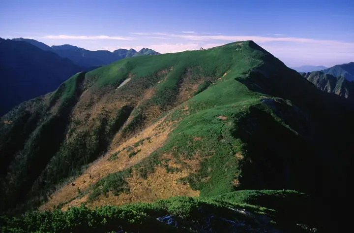
Mt. Kogouchidake is a 2,801.56-meter peak on the main crest of the Akaishi Range (Southern Alps), straddling Ōshika Village in Shimoina District of Nagano Prefecture and Aoi Ward in Shizuoka City, within South Alps National Park. It rises between Mt. Shiomi and the Arakawa Three Peaks, with an emergency hut (Kogōuchidake Hinangoya) sitting just below the summit. The summit ridge is a creeping-pine and stony alpine zone above the treeline and is part of the rock ptarmigan habitat. The standard approach climbs from the Torikura forest-road trailhead via Sanpuku-tōge-goya, and the peak is also crossed on the Shiomi–Arakawa traverse. It is featured in the Nihon Hyaku-Kōzan (100 Highest Mountains of Japan), Nihon 2500-m Peaks, and Shizuoka Hyakuzan lists.
Mt. Kogouchidake at a glance
- Weather: The most settled day in the next 7 days is Sun, November 8: clear, gusts up to 9 m/s.
Mt. Kogouchidake weather (hourly, 14 days)
Sunrise today 06:10, sunset 16:52
| Tue, 11/3 | Wed, 11/4 | Thu, 11/5 | Fri, 11/6 | Sat, 11/7 | Sun, 11/8 | Mon, 11/9 | Tue, 11/10 | Wed, 11/11 | Thu, 11/12 | Fri, 11/13 | Sat, 11/14 | Sun, 11/15 | Mon, 11/16 | Tue, 11/17 | |||||||||||||||||||||||||||||||||||||||||||||||||||||||||||||||||||||||
|---|---|---|---|---|---|---|---|---|---|---|---|---|---|---|---|---|---|---|---|---|---|---|---|---|---|---|---|---|---|---|---|---|---|---|---|---|---|---|---|---|---|---|---|---|---|---|---|---|---|---|---|---|---|---|---|---|---|---|---|---|---|---|---|---|---|---|---|---|---|---|---|---|---|---|---|---|---|---|---|---|---|---|---|---|---|
| Japan time | 15 | 17 | 19 | 21 | 23 | 1 | 3 | 5 | 7 | 9 | 11 | 13 | 15 | 18 | 21 | 0 | 3 | 6 | 9 | 12 | 15 | 18 | 21 | 0 | 3 | 6 | 9 | 12 | 15 | 18 | 21 | 0 | 3 | 6 | 9 | 12 | 15 | 18 | 21 | 0 | 3 | 6 | 9 | 12 | 15 | 18 | 21 | 0 | 3 | 6 | 9 | 15 | 21 | 3 | 9 | 15 | 21 | 3 | 9 | 15 | 21 | 3 | 9 | 15 | 21 | 3 | 9 | 15 | 21 | 3 | 9 | 15 | 21 | 3 | 9 | 15 | 21 | 3 | 9 | 15 | 21 | 3 | 9 | 15 | |
 |  |   | | | | | |   |   |   | |   |   | | | | | | |   |  | | |   |   | | | | | | | | | | | | | | | | | | | |   | |   | | | | | | | |   | |   | | |   |  | | | | | | | | | | | | | | | | |   | | | | | | ||
| Temperature | °C | 4° | -1° | -4° | -5° | -5° | -4° | -4° | -3° | -1° | 3° | 6° | 5° | 4° | 1° | 2° | 1° | 2° | 3° | 5° | 9° | 5° | 3° | 2° | 2° | 2° | 1° | 4° | 7° | 5° | -1° | -3° | -4° | -6° | -9° | -2° | 1° | 0° | -8° | -9° | -8° | -7° | -6° | 3° | 4° | 2° | -4° | -4° | -3° | -3° | -3° | 0° | 1° | -6° | -8° | -1° | -1° | -4° | -8° | -5° | -1° | -7° | -6° | -1° | -1° | -6° | -7° | -1° | 1° | -6° | -5° | 1° | 1° | -6° | -4° | 2° | 2° | 1° | 1° | 4° | 5° | -4° | -2° | 0° | 0° |
| Precipitation | mm | 0.3 | 0.8 | 0.2 | 6 | 10 | 6 | 1.3 | 1.5 | 0.2 | 0.1 | 0.3 | 0.4 | 12 | 18 | 0.4 | 0.2 | ||||||||||||||||||||||||||||||||||||||||||||||||||||||||||||||||||||
| New snow | cm | <.1 | <.1 | 0.2 | 0.3 | ||||||||||||||||||||||||||||||||||||||||||||||||||||||||||||||||||||||||||||||||
| Snow depth | cm | 0 | 0 | 0 | 0 | 0 | 0 | 0 | 0 | 0 | 0 | 0 | 0 | 0 | 0 | 0 | 0 | 0 | 0 | 0 | 0 | 0 | 0 | 0 | 0 | 0 | 0 | 0 | 0 | 0 | 0 | 0 | 0 | 0 | 0 | 0 | 0 | 0 | 0 | 0 | 0 | 0 | 0 | 0 | 0 | 0 | 0 | 0 | 0 | 0 | 0 | 0 | 0 | 0 | 0 | 0 | 0 | 0 | 0 | 0 | 0 | 0 | 0 | 0 | 0 | 0 | 0 | 0 | 0 | 0 | 0 | 0 | 0 | 0 | 0 | 0 | 0 | 0 | 0 | 0 | 0 | 0 | 0 | 0 | 0 |
| Wind | m/s | 3 | 1 | 0 | 0 | 1 | 1 | 1 | 1 | 1 | 1 | 2 | 1 | 0 | 1 | 2 | 2 | 2 | 1 | 1 | 2 | 2 | 1 | 1 | 1 | 2 | 1 | 2 | 3 | 2 | 0 | 1 | 1 | 1 | 0 | 2 | 3 | 2 | 1 | 1 | 1 | 0 | 0 | 1 | 2 | 1 | 0 | 1 | 0 | 0 | 0 | 2 | 2 | 1 | 1 | 2 | 4 | 2 | 3 | 3 | 2 | 1 | 1 | 2 | 2 | 0 | 0 | 2 | 2 | 0 | 0 | 1 | 2 | 0 | 1 | 2 | 2 | 2 | 1 | 2 | 3 | 0 | 1 | 1 | 1 |
| Wind gusts | m/s | 9 | 8 | 5 | 4 | 5 | 5 | 5 | 5 | 5 | 6 | 8 | 9 | 7 | 8 | 9 | 13 | 14 | 12 | 7 | 9 | 10 | 10 | 7 | 8 | 10 | 11 | 9 | 12 | 13 | 10 | 8 | 9 | 10 | 10 | 11 | 12 | 12 | 9 | 6 | 6 | 6 | 6 | 7 | 9 | 9 | 6 | 6 | 7 | 7 | 7 | 9 | 11 | 8 | 6 | 8 | 12 | 12 | 16 | 18 | 18 | 10 | 5 | 8 | 10 | 8 | 5 | 11 | 11 | 8 | 5 | 5 | 8 | 7 | 6 | 9 | 12 | 15 | 14 | 11 | 12 | 10 | 5 | 5 | 7 |
| Wind dir. | ↓ | ↓ | ↓ | ↓ | ↓ | ↓ | ↓ | ↓ | ↓ | ↓ | ↓ | ↓ | ↓ | ↓ | ↓ | ↓ | ↓ | ↓ | ↓ | ↓ | ↓ | ↓ | ↓ | ↓ | ↓ | ↓ | ↓ | ↓ | ↓ | ↓ | ↓ | ↓ | ↓ | ↓ | ↓ | ↓ | ↓ | ↓ | ↓ | ↓ | ↓ | ↓ | ↓ | ↓ | ↓ | ↓ | ↓ | ↓ | ↓ | ↓ | ↓ | ↓ | ↓ | ↓ | ↓ | ↓ | ↓ | ↓ | ↓ | ↓ | ↓ | ↓ | ↓ | ↓ | ↓ | ↓ | ↓ | ↓ | ↓ | ↓ | ↓ | ↓ | ↓ | ↓ | ↓ | ↓ | ↓ | ↓ | ↓ | ↓ | ↓ | ↓ | ↓ | ↓ | |
Huts, campsites and lodging near Mt. Kogouchidake
Mountain huts
- Mount Ogochidake Emergency Shelter 2026: open July 11–August 22 · sleeps 5
- Sanpuku-toge Hut 2026: open July 5–September 25 · reservation required
- Takayamaura Shelter 2026: open July 11–August 22 · sleeps 10
- Arakawa Nakadake Evacuation Hut 2026: open July 11–September 22 · sleeps 5
- Shiomi Hut 2026: open July 1–October 12 · reservation required · sleeps 34
Campsites
- Sanpuku-toge Camping Area
Lists that include Mt. Kogouchidake
Japan's 100 Highest Mountains · 100 Mountains of Shizuoka · Elevations of 1003 Mountains of Japan
Mt. Kogouchidake facts
- Also known as
- おごうちだけ
- Elevation
- 2,802 m
- Location
- Ōshika-mura, Nagano / Shizuoka, Shizuoka
35.537744, 138.153049 - National Park
- 南アルプス国立公園
- Website
- sanpukutouge.com
- Trail Map
- www.city.shizuoka.lg.jp (PDF)
- Access Information
- www.vill.ooshika.nagano.jp
- Wikipedia
- ja.wikipedia.org