
Mt. Hirogouchidake
広河内岳
Shizuoka, Shizuoka / Hayakawa, Yamanashi · Elevation 2,895 m
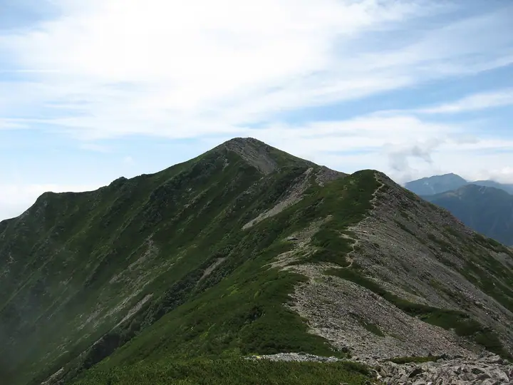
Mt. Hirogōchidake is a 2,895 m peak on the Yamanashi-Shizuoka prefectural border between Hayakawa Town and Aoi Ward of Shizuoka City, lying within Minami Alps National Park as the first major summit on the Shirane Nanrei (White-Peak South Ridge) running south from Mt. Nōtori. From the Daimon-zawa junction the ridge continues southward over Mts. Ōkago and Sasayama (Kurokōchi-dake). Climbers typically reach it from Naradā via the Daimon-zawa trail and Mt. Nōtori with an overnight at the Nōtori hut, or by combining the steep Sasayama "Direct Ridge" with a traverse across Sasayama, Ōkago and Hirogōchidake. The peak is listed among the Japan Top 100 High Mountains, Kai 100 and Shizuoka 100 mountains.
Mt. Hirogouchidake at a glance
- Weather: The most settled day in the next 7 days is Sun, November 8: clear, gusts up to 10 m/s. Sat, Nov 7: strong wind (gusts up to 16 m/s).
Mt. Hirogouchidake weather (hourly, 14 days)
Sunrise today 06:10, sunset 16:51
| Tue, 11/3 | Wed, 11/4 | Thu, 11/5 | Fri, 11/6 | Sat, 11/7 | Sun, 11/8 | Mon, 11/9 | Tue, 11/10 | Wed, 11/11 | Thu, 11/12 | Fri, 11/13 | Sat, 11/14 | Sun, 11/15 | Mon, 11/16 | Tue, 11/17 | |||||||||||||||||||||||||||||||||||||||||||||||||||||||||||||||||||||||
|---|---|---|---|---|---|---|---|---|---|---|---|---|---|---|---|---|---|---|---|---|---|---|---|---|---|---|---|---|---|---|---|---|---|---|---|---|---|---|---|---|---|---|---|---|---|---|---|---|---|---|---|---|---|---|---|---|---|---|---|---|---|---|---|---|---|---|---|---|---|---|---|---|---|---|---|---|---|---|---|---|---|---|---|---|---|
| Japan time | 15 | 17 | 19 | 21 | 23 | 1 | 3 | 5 | 7 | 9 | 11 | 13 | 15 | 18 | 21 | 0 | 3 | 6 | 9 | 12 | 15 | 18 | 21 | 0 | 3 | 6 | 9 | 12 | 15 | 18 | 21 | 0 | 3 | 6 | 9 | 12 | 15 | 18 | 21 | 0 | 3 | 6 | 9 | 12 | 15 | 18 | 21 | 0 | 3 | 6 | 9 | 15 | 21 | 3 | 9 | 15 | 21 | 3 | 9 | 15 | 21 | 3 | 9 | 15 | 21 | 3 | 9 | 15 | 21 | 3 | 9 | 15 | 21 | 3 | 9 | 15 | 21 | 3 | 9 | 15 | 21 | 3 | 9 | 15 | |
 |   | |   | | | | |   |   | |   |   |   | | | | | | |   |   | | |   |   | | | |  | | | | | | | | | | | | | | | | | |   | | | | | |   | | | | | | |   |  | | | | | | | | | | | | | | | | |   | | | | | | ||
| Temperature | °C | 3° | -3° | -5° | -6° | -7° | -6° | -5° | -4° | -3° | 2° | 4° | 5° | 2° | 0° | 0° | 0° | 0° | 2° | 5° | 8° | 4° | 2° | 0° | 0° | 1° | 0° | 3° | 7° | 5° | -1° | -3° | -6° | -8° | -10° | -3° | 1° | 0° | -8° | -8° | -8° | -7° | -6° | 1° | 3° | 1° | -6° | -4° | -4° | -4° | -5° | -1° | 0° | -7° | -9° | -3° | -2° | -5° | -8° | -6° | -2° | -8° | -6° | -2° | -1° | -7° | -6° | -2° | 0° | -6° | -5° | 1° | 1° | -7° | -6° | 1° | 1° | 0° | 0° | 4° | 5° | -4° | -4° | -1° | -1° |
| Precipitation | mm | 0.3 | 0.9 | 0.3 | 6 | 11 | 6 | 0.1 | 1.3 | 0.1 | 0.7 | 0.1 | 0.1 | 10 | 16 | 0.3 | |||||||||||||||||||||||||||||||||||||||||||||||||||||||||||||||||||||
| New snow | cm | <.1 | <.1 | <.1 | <.1 | ||||||||||||||||||||||||||||||||||||||||||||||||||||||||||||||||||||||||||||||||
| Snow depth | cm | 0 | 0 | 0 | 0 | 0 | 0 | 0 | 0 | 0 | 0 | 0 | 0 | 0 | 0 | 0 | 0 | 0 | 0 | 0 | 0 | 0 | 0 | 0 | 0 | 0 | 0 | 0 | 0 | 0 | 0 | 0 | 0 | 0 | 0 | 0 | 0 | 0 | 0 | 0 | 0 | 0 | 0 | 0 | 0 | 0 | 0 | 0 | 0 | 0 | 0 | 0 | 0 | 0 | 0 | 0 | 0 | 0 | 0 | 0 | 0 | 0 | 0 | 0 | 0 | 0 | 0 | 0 | 0 | 0 | 0 | 0 | 0 | 0 | 0 | 0 | 0 | 0 | 0 | 0 | 0 | 0 | 0 | 0 | 0 |
| Wind | m/s | 1 | 0 | 1 | 1 | 1 | 1 | 1 | 1 | 1 | 1 | 1 | 1 | 1 | 2 | 2 | 2 | 2 | 1 | 0 | 1 | 2 | 1 | 1 | 1 | 2 | 1 | 2 | 2 | 2 | 2 | 2 | 2 | 3 | 2 | 3 | 2 | 2 | 1 | 1 | 1 | 1 | 1 | 1 | 1 | 1 | 0 | 1 | 2 | 1 | 1 | 2 | 1 | 0 | 1 | 1 | 2 | 2 | 3 | 3 | 1 | 0 | 1 | 2 | 2 | 0 | 1 | 1 | 0 | 1 | 1 | 1 | 1 | 1 | 1 | 2 | 2 | 2 | 2 | 2 | 2 | 1 | 1 | 1 | 1 |
| Wind gusts | m/s | 9 | 8 | 7 | 8 | 8 | 9 | 8 | 8 | 8 | 8 | 9 | 8 | 8 | 10 | 11 | 13 | 15 | 14 | 9 | 9 | 14 | 13 | 11 | 12 | 14 | 14 | 12 | 13 | 13 | 12 | 14 | 15 | 16 | 16 | 16 | 16 | 14 | 13 | 11 | 11 | 11 | 10 | 9 | 10 | 10 | 8 | 11 | 12 | 12 | 12 | 12 | 13 | 8 | 9 | 11 | 13 | 12 | 18 | 19 | 18 | 9 | 8 | 10 | 11 | 10 | 7 | 10 | 10 | 7 | 6 | 6 | 8 | 8 | 10 | 11 | 14 | 17 | 17 | 15 | 12 | 11 | 7 | 7 | 8 |
| Wind dir. | ↓ | ↓ | ↓ | ↓ | ↓ | ↓ | ↓ | ↓ | ↓ | ↓ | ↓ | ↓ | ↓ | ↓ | ↓ | ↓ | ↓ | ↓ | ↓ | ↓ | ↓ | ↓ | ↓ | ↓ | ↓ | ↓ | ↓ | ↓ | ↓ | ↓ | ↓ | ↓ | ↓ | ↓ | ↓ | ↓ | ↓ | ↓ | ↓ | ↓ | ↓ | ↓ | ↓ | ↓ | ↓ | ↓ | ↓ | ↓ | ↓ | ↓ | ↓ | ↓ | ↓ | ↓ | ↓ | ↓ | ↓ | ↓ | ↓ | ↓ | ↓ | ↓ | ↓ | ↓ | ↓ | ↓ | ↓ | ↓ | ↓ | ↓ | ↓ | ↓ | ↓ | ↓ | ↓ | ↓ | ↓ | ↓ | ↓ | ↓ | ↓ | ↓ | ↓ | ↓ | |
Huts, campsites and lodging near Mt. Hirogouchidake
Mountain huts
- 大門沢小屋 2026: open July 1–October 15 · reservation required · sleeps 100
- Notori Hut reservation required
- Kumanodaira Hut 2026: open July 11–September 22 · reservation required · sleeps 30
Campsites
- Notori Campground
Lists that include Mt. Hirogouchidake
Japan's 100 Highest Mountains · 100 Mountains of Shizuoka · Elevations of 1003 Mountains of Japan
Mt. Hirogouchidake facts
- Elevation
- 2,895 m
- Location
- Shizuoka, Shizuoka / Hayakawa, Yamanashi
35.606009, 138.235860 - National Park
- 南アルプス国立公園
- Website
- www.env.go.jp (PDF)
- Trail Map
- www.env.go.jp (PDF)
- Wikipedia
- ja.wikipedia.org