
Mount Zaō
熊野岳
Yamagata, Yamagata · Elevation 1,841 m
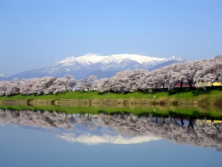
Mount Zaō is an active volcano in the Ōu Mountains spanning the Yamagata–Miyagi border; its highest peak, Kumano-dake (1,841 m), lies in Yamagata City. Part of Zaō Quasi-National Park, it is known for the emerald waters of Okama crater lake and winter rime-covered trees. Ropeways from Zaō Onsen and lifts along the Zaō Echo Line provide easy access to the ridge of this prominent Tohoku mountain.
Mount Zaō at a glance
- Weather: The most settled day in the next 7 days is Wed, November 4: clear, gusts up to 9 m/s. Fri, Nov 6, Sat, Nov 7, Sun, Nov 8: strong wind (gusts up to 28 m/s).
- Route: The shortest is Mount Zao Kumanodake and Kattadake Loop via Okama and Umanose: about 2 h 31 min, 5.0 km, about 170 m of climbing.
Mount Zaō weather (hourly, 14 days)
Sunrise today 06:05, sunset 16:38
| Tue, 11/3 | Wed, 11/4 | Thu, 11/5 | Fri, 11/6 | Sat, 11/7 | Sun, 11/8 | Mon, 11/9 | Tue, 11/10 | Wed, 11/11 | Thu, 11/12 | Fri, 11/13 | Sat, 11/14 | Sun, 11/15 | Mon, 11/16 | Tue, 11/17 | |||||||||||||||||||||||||||||||||||||||||||||||||||||||||||||||||||||||
|---|---|---|---|---|---|---|---|---|---|---|---|---|---|---|---|---|---|---|---|---|---|---|---|---|---|---|---|---|---|---|---|---|---|---|---|---|---|---|---|---|---|---|---|---|---|---|---|---|---|---|---|---|---|---|---|---|---|---|---|---|---|---|---|---|---|---|---|---|---|---|---|---|---|---|---|---|---|---|---|---|---|---|---|---|---|
| Japan time | 21 | 23 | 1 | 3 | 5 | 7 | 9 | 11 | 13 | 15 | 17 | 19 | 21 | 0 | 3 | 6 | 9 | 12 | 15 | 18 | 21 | 0 | 3 | 6 | 9 | 12 | 15 | 18 | 21 | 0 | 3 | 6 | 9 | 12 | 15 | 18 | 21 | 0 | 3 | 6 | 9 | 12 | 15 | 18 | 21 | 0 | 3 | 6 | 9 | 12 | 15 | 21 | 3 | 9 | 15 | 21 | 3 | 9 | 15 | 21 | 3 | 9 | 15 | 21 | 3 | 9 | 15 | 21 | 3 | 9 | 15 | 21 | 3 | 9 | 15 | 21 | 3 | 9 | 15 | 21 | 3 | 9 | 15 | 21 | |
 | | |   | |   | | |   |   | | |   |   | | |   | | | |   | | | |   |   | | | | | |   |   | | |   | |   | | | |   | | | | | | |   | | | |   |  | | | |   | | | | | |   | | | | | | | |  | | | | |   | | | | | | | | ||
| Temperature | °C | -2° | -1° | -2° | -2° | -2° | 0° | 5° | 6° | 7° | 6° | 2° | 1° | 2° | 2° | 4° | 4° | 5° | 7° | 7° | 6° | 6° | 6° | 5° | 5° | 7° | 8° | 7° | 4° | 2° | 0° | -2° | -2° | -3° | -2° | -2° | -4° | -4° | -4° | -4° | -4° | -1° | 0° | -1° | -3° | -5° | -4° | -4° | -4° | -3° | 1° | 0° | -5° | -6° | 0° | 0° | -2° | -2° | -1° | 1° | -4° | -3° | 0° | 1° | -2° | 0° | -1° | -1° | -4° | -5° | 0° | 3° | -3° | -1° | 7° | 8° | 3° | 3° | 6° | 2° | -4° | -6° | -2° | 1° | -3° |
| Precipitation | mm | 0.2 | 6 | 10 | 7 | 1.6 | 0.8 | 0.5 | 1.2 | 1.3 | 0.9 | 0.9 | 1.0 | 0.6 | 0.4 | 0.9 | 0.9 | 1.2 | 1.6 | 1.6 | 1.2 | 1.0 | 0.4 | 0.2 | 0.1 | 0.3 | 0.9 | 0.6 | 6 | 1.6 | 1.0 | 0.2 | 0.7 | 1.0 | 0.2 | 2.4 | 7 | 0.8 | 3.5 | 2.2 | |||||||||||||||||||||||||||||||||||||||||||||
| New snow | cm | <.1 | 0.8 | 0.9 | 0.9 | 1.0 | 0.3 | 0.2 | <.1 | <.1 | 0.3 | 0.9 | 0.5 | 1.2 | 0.7 | ||||||||||||||||||||||||||||||||||||||||||||||||||||||||||||||||||||||
| Snow depth | cm | 0 | 0 | 0 | 0 | 0 | 0 | 0 | 0 | 0 | 0 | 0 | 0 | 0 | 0 | 0 | 0 | 0 | 0 | 0 | 0 | 0 | 0 | 0 | 0 | 0 | 0 | 0 | 0 | 0 | 0 | 0 | 0 | <1 | <1 | <1 | <1 | 2 | 2 | 2 | <1 | <1 | <1 | <1 | <1 | 0 | 0 | 0 | <1 | <1 | <1 | 0 | 0 | 0 | 0 | 0 | 0 | <1 | <1 | 0 | 0 | 0 | 0 | 0 | 0 | 0 | 0 | 0 | 0 | 0 | 0 | 0 | 0 | 0 | 0 | 0 | 0 | 0 | 0 | 0 | 0 | 0 | 0 | 0 | 0 |
| Wind | m/s | 2 | 1 | 1 | 1 | 1 | 2 | 2 | 2 | 1 | 2 | 2 | 2 | 2 | 2 | 2 | 2 | 2 | 2 | 2 | 1 | 0 | 1 | 2 | 2 | 3 | 6 | 6 | 5 | 4 | 5 | 5 | 5 | 4 | 6 | 6 | 6 | 6 | 6 | 6 | 6 | 6 | 7 | 6 | 3 | 1 | 1 | 1 | 0 | 1 | 1 | 0 | 1 | 1 | 1 | 3 | 2 | 3 | 4 | 5 | 2 | 2 | 2 | 3 | 2 | 1 | 4 | 6 | 3 | 2 | 2 | 1 | 1 | 1 | 1 | 1 | 1 | 1 | 2 | 4 | 5 | 3 | 2 | 1 | 0 |
| Wind gusts | m/s | 10 | 10 | 8 | 8 | 8 | 9 | 9 | 9 | 7 | 7 | 8 | 9 | 11 | 12 | 12 | 10 | 11 | 11 | 9 | 5 | 4 | 6 | 10 | 11 | 17 | 20 | 23 | 22 | 22 | 18 | 20 | 20 | 20 | 27 | 28 | 27 | 25 | 25 | 24 | 24 | 21 | 20 | 20 | 17 | 12 | 8 | 7 | 8 | 9 | 9 | 8 | 9 | 8 | 7 | 10 | 13 | 13 | 15 | 20 | 17 | 11 | 9 | 11 | 11 | 10 | 14 | 20 | 19 | 12 | 10 | 8 | 5 | 7 | 8 | 6 | 9 | 9 | 11 | 17 | 22 | 18 | 13 | 8 | 5 |
| Wind dir. | ↓ | ↓ | ↓ | ↓ | ↓ | ↓ | ↓ | ↓ | ↓ | ↓ | ↓ | ↓ | ↓ | ↓ | ↓ | ↓ | ↓ | ↓ | ↓ | ↓ | ↓ | ↓ | ↓ | ↓ | ↓ | ↓ | ↓ | ↓ | ↓ | ↓ | ↓ | ↓ | ↓ | ↓ | ↓ | ↓ | ↓ | ↓ | ↓ | ↓ | ↓ | ↓ | ↓ | ↓ | ↓ | ↓ | ↓ | ↓ | ↓ | ↓ | ↓ | ↓ | ↓ | ↓ | ↓ | ↓ | ↓ | ↓ | ↓ | ↓ | ↓ | ↓ | ↓ | ↓ | ↓ | ↓ | ↓ | ↓ | ↓ | ↓ | ↓ | ↓ | ↓ | ↓ | ↓ | ↓ | ↓ | ↓ | ↓ | ↓ | ↓ | ↓ | ↓ | ↓ | |
Mount Zaō live cameras
Mount Zaō hiking routes
- Mount Zao Kumanodake and Kattadake Loop via Okama and Umanose 5.0 km · Ascent 171 m 蔵王刈田山頂 (Bus stop), 第1駐車場, 第2駐車場
- Mount Zao Return from Daikokuten over Kattadake and the Umanose Ridge to Kumanodake 8.3 km · Ascent 463 m 大黒天 (Bus stop) (parking)
Hiking times are estimates calculated from the terrain.
Huts, campsites and lodging near Mount Zaō
Mountain huts
- 蔵王山神社避難小屋
- Mt. Kumano Summit Emergency Shelter
- Mt. Kumano Emergency Shelter unstaffed · sleeps 10
- Mt. Katta Emergency Shelter
- 御田の神避難小屋 unstaffed
Campsites
- Zaobodaira Camping Ground
Lodging
- Lodge Zao Dokko Numa
- Zao Astraea Hotel
- 蔵王坊平高原ライザウッディロッジ
- Zao Kokusai Hotel
- Hotel Largen Zao
Lists that include Mount Zaō
100 Famous Japanese Mountains · Japan 200 Famous Mountains · Japan's 300 Famous Mountains · New Japan 100 Famous Mountains · 100 Famous Hot Spring Mountains · Tohoku 100 Famous Mountains · Yamagata 100 Famous Mountains · Elevations of 1003 Mountains of Japan · 1000 Mountains of Japan
Mount Zaō facts
- Also known as
- 蔵王連峰 · Zaozan
- Elevation
- 1,841 m
- Location
- Yamagata, Yamagata
38.143889, 140.439761 - National Park
- 蔵王国定公園
- Volcano
- Active volcano (蔵王山)
- Season Opens
- June 1
- Season Closes
- October 31
- Website
- yamagatayama.com
- Trail Map
- zaoropeway.co.jp
- Access Information
- www.zaoropeway.co.jp
- Wikipedia
- ja.wikipedia.org