
Mt. Byoubudake
屏風岳
Shichikashuku, Miyagi · Elevation 1,825 m
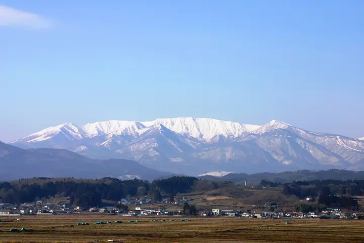
Mount Byōbudake (1,825 m), on the border of Zaō and Shichikashuku towns in Miyagi Prefecture, is the highest peak of the Zaō range and the highest point in Miyagi. Set within Zaō Quasi-National Park, its eastern face drops away in folding-screen-like cliffs that give the mountain its name. It lies on the South Zaō traverse from Karita Pass via Maeyama and Sugigamine, passing Shibakusadaira, Zaō's only high-moor wetland. It is counted among the 100 Mountains with First-Order Triangulation Points, the 100 Mountains of Tōhoku, and the highest peaks of each prefecture.
Mt. Byoubudake at a glance
- Weather: The most settled day in the next 7 days is Wed, November 4: clear, gusts up to 8 m/s. Fri, Nov 6, Sat, Nov 7, Sun, Nov 8: strong wind (gusts up to 25 m/s).
- Route: The shortest is South Zao Ridge from Katta Pass to Mount Fubo: about 8 h 6 min, 14.5 km, about 910 m of climbing.
Mt. Byoubudake weather (hourly, 14 days)
Sunrise today 06:05, sunset 16:38
| Tue, 11/3 | Wed, 11/4 | Thu, 11/5 | Fri, 11/6 | Sat, 11/7 | Sun, 11/8 | Mon, 11/9 | Tue, 11/10 | Wed, 11/11 | Thu, 11/12 | Fri, 11/13 | Sat, 11/14 | Sun, 11/15 | Mon, 11/16 | Tue, 11/17 | |||||||||||||||||||||||||||||||||||||||||||||||||||||||||||||||||||||||
|---|---|---|---|---|---|---|---|---|---|---|---|---|---|---|---|---|---|---|---|---|---|---|---|---|---|---|---|---|---|---|---|---|---|---|---|---|---|---|---|---|---|---|---|---|---|---|---|---|---|---|---|---|---|---|---|---|---|---|---|---|---|---|---|---|---|---|---|---|---|---|---|---|---|---|---|---|---|---|---|---|---|---|---|---|---|
| Japan time | 15 | 17 | 19 | 21 | 23 | 1 | 3 | 5 | 7 | 9 | 11 | 13 | 15 | 18 | 21 | 0 | 3 | 6 | 9 | 12 | 15 | 18 | 21 | 0 | 3 | 6 | 9 | 12 | 15 | 18 | 21 | 0 | 3 | 6 | 9 | 12 | 15 | 18 | 21 | 0 | 3 | 6 | 9 | 12 | 15 | 18 | 21 | 0 | 3 | 6 | 9 | 15 | 21 | 3 | 9 | 15 | 21 | 3 | 9 | 15 | 21 | 3 | 9 | 15 | 21 | 3 | 9 | 15 | 21 | 3 | 9 | 15 | 21 | 3 | 9 | 15 | 21 | 3 | 9 | 15 | 21 | 3 | 9 | 15 | |
 |  | | | | | | | |   | | |   |   | |   | | |   | | |   |   |   | | | |   |   | | | | | |   | |   |   |   | | | | | | | | | | | | | | |   | | | | | | | | | | | | |   | | | | | |  | | | | | | | | |   | | | ||
| Temperature | °C | 2° | -1° | -3° | -4° | -4° | -4° | -4° | -3° | -1° | 2° | 4° | 6° | 4° | 0° | 1° | 1° | 1° | 3° | 4° | 4° | 5° | 4° | 4° | 4° | 3° | 4° | 6° | 7° | 6° | 3° | 1° | -1° | -3° | -4° | -4° | -4° | -4° | -6° | -6° | -6° | -6° | -5° | -4° | -2° | -2° | -4° | -5° | -5° | -5° | -6° | -2° | 0° | -6° | -7° | -2° | -2° | -3° | -4° | -3° | 0° | -5° | -5° | -1° | -1° | -4° | -2° | -2° | -2° | -6° | -7° | -2° | 1° | -3° | -3° | 4° | 5° | 1° | 1° | 5° | 1° | -5° | -7° | -4° | -1° |
| Precipitation | mm | 0.2 | 1.9 | 10 | 7 | 3.0 | 0.7 | 0.5 | 0.2 | 0.8 | 0.5 | 0.4 | 0.3 | 0.5 | 0.9 | 1.7 | 1.5 | 1.2 | 0.8 | 0.9 | 0.3 | 0.2 | 0.2 | 0.2 | 0.3 | 0.2 | 0.5 | 2.1 | 1.2 | 0.4 | 0.3 | 0.6 | 2.8 | 8 | 0.6 | 2.6 | 1.8 | ||||||||||||||||||||||||||||||||||||||||||||||||
| New snow | cm | 0.4 | 0.5 | 0.7 | 0.7 | 0.6 | 0.1 | <.1 | <.1 | <.1 | 0.2 | 0.1 | 0.6 | <.1 | |||||||||||||||||||||||||||||||||||||||||||||||||||||||||||||||||||||||
| Snow depth | cm | 0 | 0 | 0 | 0 | 0 | 0 | 0 | 0 | 0 | 0 | 0 | 0 | 0 | 0 | 0 | 0 | 0 | 0 | 0 | 0 | 0 | 0 | 0 | 0 | 0 | 0 | 0 | 0 | 0 | 0 | 0 | 0 | 0 | 0 | <1 | <1 | <1 | <1 | 1 | 1 | <1 | <1 | <1 | <1 | 0 | 0 | 0 | 0 | 0 | 0 | 0 | 0 | 0 | 0 | 0 | 0 | 0 | 0 | <1 | 0 | 0 | 0 | 0 | 0 | 0 | 0 | 0 | 0 | 0 | 0 | 0 | 0 | 0 | 0 | 0 | 0 | 0 | 0 | 0 | 0 | 0 | 0 | 0 | 0 |
| Wind | m/s | 4 | 3 | 3 | 2 | 2 | 1 | 2 | 2 | 2 | 2 | 1 | 1 | 3 | 2 | 3 | 2 | 2 | 1 | 2 | 2 | 1 | 0 | 0 | 3 | 3 | 4 | 5 | 8 | 8 | 7 | 6 | 5 | 5 | 5 | 5 | 6 | 6 | 6 | 7 | 7 | 7 | 6 | 6 | 7 | 6 | 4 | 3 | 3 | 2 | 2 | 2 | 2 | 2 | 2 | 1 | 4 | 2 | 5 | 5 | 6 | 3 | 2 | 3 | 4 | 2 | 2 | 4 | 6 | 3 | 2 | 2 | 1 | 0 | 2 | 1 | 1 | 0 | 0 | 3 | 4 | 5 | 4 | 2 | 1 |
| Wind gusts | m/s | 17 | 13 | 10 | 9 | 8 | 7 | 8 | 8 | 8 | 8 | 8 | 5 | 7 | 8 | 9 | 9 | 9 | 8 | 8 | 8 | 6 | 4 | 4 | 8 | 10 | 13 | 15 | 23 | 24 | 24 | 20 | 18 | 19 | 17 | 18 | 23 | 25 | 22 | 21 | 21 | 21 | 20 | 18 | 21 | 22 | 19 | 12 | 11 | 10 | 7 | 7 | 8 | 8 | 8 | 7 | 10 | 11 | 16 | 17 | 19 | 16 | 9 | 10 | 12 | 12 | 9 | 13 | 18 | 17 | 10 | 8 | 7 | 5 | 7 | 8 | 6 | 6 | 5 | 11 | 15 | 19 | 15 | 12 | 8 |
| Wind dir. | ↓ | ↓ | ↓ | ↓ | ↓ | ↓ | ↓ | ↓ | ↓ | ↓ | ↓ | ↓ | ↓ | ↓ | ↓ | ↓ | ↓ | ↓ | ↓ | ↓ | ↓ | ↓ | ↓ | ↓ | ↓ | ↓ | ↓ | ↓ | ↓ | ↓ | ↓ | ↓ | ↓ | ↓ | ↓ | ↓ | ↓ | ↓ | ↓ | ↓ | ↓ | ↓ | ↓ | ↓ | ↓ | ↓ | ↓ | ↓ | ↓ | ↓ | ↓ | ↓ | ↓ | ↓ | ↓ | ↓ | ↓ | ↓ | ↓ | ↓ | ↓ | ↓ | ↓ | ↓ | ↓ | ↓ | ↓ | ↓ | ↓ | ↓ | ↓ | ↓ | ↓ | ↓ | ↓ | ↓ | ↓ | ↓ | ↓ | ↓ | ↓ | ↓ | ↓ | ↓ | |
Mt. Byoubudake hiking routes
Hiking times are estimates calculated from the terrain.
Huts, campsites and lodging near Mt. Byoubudake
Mountain huts
- Katta Pass Emergency Shelter unstaffed
- 聖山平ヒュッテ
- 仙台一高井戸沢小屋
- 清渓小屋
- Mt. Katta Emergency Shelter
Lodging
- 宮城蔵王高原ホテル
Lists that include Mt. Byoubudake
100 Famous Mountains with First-order Triangulation Points · Highest Peaks by Prefecture · Tohoku 100 Famous Mountains · Elevations of 1003 Mountains of Japan · 1000 Mountains of Japan
Mt. Byoubudake facts
- Elevation
- 1,825 m
- Location
- Shichikashuku, Miyagi
38.095715, 140.476175 - National Park
- 蔵王国定公園
- Website
- www.zao-machi.com
- Trail Map
- www.pref.miyagi.jp (PDF)
- Wikipedia
- ja.wikipedia.org