
Mount Omeshi
御飯岳
Nagano / Takayama, Gunma / Tsumagoi, Gunma · Elevation 2,160 m
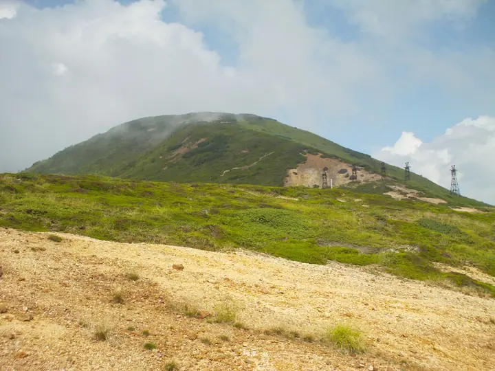
A 2,160 m peak at the southern end of the Shiga Highlands within Jōshin'etsu-Kōgen National Park, straddling the border between Tsumagoi Village in Gunma and Takayama Village in Nagano. It is the highest of the three Agatsuma volcanic peaks reached from Kenashi Pass — alongside Hafū-dake and Donabe-yama — and is featured in the Shinshu Mountaineering Guide maintained by the Nagano Prefectural Mountaineering Association. The summit looks across to the Shiga Highlands, Mount Kusatsu-Shirane and Mount Azumaya, and the peak is included in lists such as Shinshu Hyakumeizan and Gunma Hyakumeizan.
Mount Omeshi at a glance
- Weather: The most settled day in the next 7 days is Wed, November 4: clear, gusts up to 7 m/s.
Mount Omeshi weather (hourly, 14 days)
Sunrise today 06:11, sunset 16:49
| Tue, 11/3 | Wed, 11/4 | Thu, 11/5 | Fri, 11/6 | Sat, 11/7 | Sun, 11/8 | Mon, 11/9 | Tue, 11/10 | Wed, 11/11 | Thu, 11/12 | Fri, 11/13 | Sat, 11/14 | Sun, 11/15 | Mon, 11/16 | Tue, 11/17 | |||||||||||||||||||||||||||||||||||||||||||||||||||||||||||||||||||||||
|---|---|---|---|---|---|---|---|---|---|---|---|---|---|---|---|---|---|---|---|---|---|---|---|---|---|---|---|---|---|---|---|---|---|---|---|---|---|---|---|---|---|---|---|---|---|---|---|---|---|---|---|---|---|---|---|---|---|---|---|---|---|---|---|---|---|---|---|---|---|---|---|---|---|---|---|---|---|---|---|---|---|---|---|---|---|
| Japan time | 15 | 17 | 19 | 21 | 23 | 1 | 3 | 5 | 7 | 9 | 11 | 13 | 15 | 18 | 21 | 0 | 3 | 6 | 9 | 12 | 15 | 18 | 21 | 0 | 3 | 6 | 9 | 12 | 15 | 18 | 21 | 0 | 3 | 6 | 9 | 12 | 15 | 18 | 21 | 0 | 3 | 6 | 9 | 12 | 15 | 18 | 21 | 0 | 3 | 6 | 9 | 15 | 21 | 3 | 9 | 15 | 21 | 3 | 9 | 15 | 21 | 3 | 9 | 15 | 21 | 3 | 9 | 15 | 21 | 3 | 9 | 15 | 21 | 3 | 9 | 15 | 21 | 3 | 9 | 15 | 21 | 3 | 9 | 15 | |
  |   | | |  | | | |  |   | | | |   | |   | | |   | | | | | | |   | | | | |   | | | |   |   |   | | | | | | | | | | | |   |   | | | | | | | |   | | | | | | |  | |   | | | | | | | | | | | |   | | | | | | ||
| Temperature | °C | 3° | -1° | -3° | -5° | -4° | -4° | -4° | -3° | -2° | 3° | 6° | 7° | 6° | 1° | 1° | 1° | 1° | 2° | 5° | 9° | 9° | 5° | 6° | 4° | 4° | 3° | 7° | 10° | 8° | 3° | 1° | 0° | -1° | -2° | -1° | 1° | -1° | -4° | -5° | -5° | -4° | -5° | -2° | 0° | -1° | -3° | -4° | -3° | -2° | -2° | 1° | 1° | -3° | -2° | 0° | 3° | -3° | -4° | -6° | -4° | -4° | -5° | -2° | 0° | -7° | -3° | -3° | -4° | -5° | -8° | 0° | 4° | -4° | -2° | 3° | 6° | 0° | 3° | 4° | 1° | -4° | -6° | -2° | 1° |
| Precipitation | mm | 0.7 | 10 | 5 | 1.5 | 1.0 | 0.1 | 0.2 | 0.2 | 0.4 | 0.4 | 0.2 | 1.9 | 3.6 | 3.6 | 1.0 | 3.4 | 1.3 | 5 | 5 | 0.1 | 1.5 | 1.8 | ||||||||||||||||||||||||||||||||||||||||||||||||||||||||||||||
| New snow | cm | <.1 | <.1 | 0.3 | 0.1 | 1.0 | 3.6 | 3.2 | 0.8 | 2.6 | 1.0 | 0.1 | |||||||||||||||||||||||||||||||||||||||||||||||||||||||||||||||||||||||||
| Snow depth | cm | 0 | 0 | 0 | 0 | 0 | 0 | 0 | 0 | 0 | 0 | 0 | 0 | 0 | 0 | 0 | 0 | 0 | 0 | 0 | 0 | 0 | 0 | 0 | 0 | 0 | 0 | 0 | 0 | 0 | 0 | 0 | 0 | 0 | 0 | 0 | 0 | 0 | 0 | 0 | 0 | 0 | 0 | 0 | 0 | 0 | 0 | 0 | 0 | 0 | 0 | 0 | 0 | 0 | 0 | 0 | 0 | 0 | <1 | 3 | 5 | 5 | 5 | 4 | 4 | 4 | 3 | 5 | 5 | 5 | 5 | 5 | 4 | 3 | 3 | 3 | 2 | 1 | <1 | <1 | 0 | 0 | 0 | 0 | 0 |
| Wind | m/s | 2 | 1 | 1 | 1 | 1 | 1 | 1 | 1 | 0 | 0 | 0 | 1 | 1 | 2 | 3 | 2 | 2 | 2 | 0 | 1 | 1 | 1 | 0 | 0 | 0 | 0 | 1 | 4 | 3 | 1 | 2 | 3 | 2 | 3 | 3 | 4 | 4 | 2 | 2 | 1 | 3 | 3 | 3 | 3 | 3 | 1 | 0 | 0 | 0 | 0 | 0 | 2 | 1 | 0 | 1 | 1 | 1 | 5 | 4 | 4 | 2 | 1 | 1 | 1 | 1 | 0 | 2 | 3 | 2 | 1 | 1 | 1 | 1 | 0 | 0 | 1 | 1 | 2 | 1 | 5 | 3 | 2 | 1 | 1 |
| Wind gusts | m/s | 9 | 7 | 4 | 3 | 3 | 3 | 3 | 3 | 2 | 4 | 5 | 6 | 7 | 7 | 8 | 9 | 8 | 7 | 6 | 6 | 6 | 4 | 3 | 4 | 4 | 4 | 7 | 12 | 13 | 10 | 8 | 9 | 9 | 8 | 11 | 15 | 15 | 13 | 8 | 6 | 9 | 10 | 9 | 9 | 10 | 8 | 4 | 4 | 4 | 5 | 5 | 7 | 7 | 3 | 6 | 10 | 8 | 18 | 20 | 20 | 16 | 8 | 4 | 6 | 5 | 5 | 9 | 13 | 12 | 8 | 5 | 4 | 4 | 4 | 5 | 8 | 7 | 12 | 9 | 16 | 16 | 11 | 6 | 6 |
| Wind dir. | ↓ | ↓ | ↓ | ↓ | ↓ | ↓ | ↓ | ↓ | ↓ | ↓ | ↓ | ↓ | ↓ | ↓ | ↓ | ↓ | ↓ | ↓ | ↓ | ↓ | ↓ | ↓ | ↓ | ↓ | ↓ | ↓ | ↓ | ↓ | ↓ | ↓ | ↓ | ↓ | ↓ | ↓ | ↓ | ↓ | ↓ | ↓ | ↓ | ↓ | ↓ | ↓ | ↓ | ↓ | ↓ | ↓ | ↓ | ↓ | ↓ | ↓ | ↓ | ↓ | ↓ | ↓ | ↓ | ↓ | ↓ | ↓ | ↓ | ↓ | ↓ | ↓ | ↓ | ↓ | ↓ | ↓ | ↓ | ↓ | ↓ | ↓ | ↓ | ↓ | ↓ | ↓ | ↓ | ↓ | ↓ | ↓ | ↓ | ↓ | ↓ | ↓ | ↓ | ↓ | |
Huts, campsites and lodging near Mount Omeshi
Campsites
- 五味池破風高原オートキャンプ場
Lodging
- 豊国館
- 万座プリンスホテル
- 万座亭
- Manza Kogen Hotel
- 万座温泉 日進舘
Lists that include Mount Omeshi
Shinshu 100 Famous Mountains · Gunma 100 Famous Mountains · 1000 Mountains of Japan
Mount Omeshi facts
- Elevation
- 2,160 m
- Location
- Nagano / Takayama, Gunma / Tsumagoi, Gunma
36.628762, 138.458531 - National Park
- 上信越高原国立公園
- Website
- www.tsumagoi-kankou.jp
- Trail Map
- www.gunma-trail.jp