
Mount Azumaya
四阿山
Tsumagoi, Gunma · Elevation 2,354 m
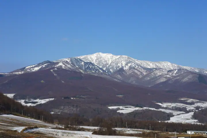
Mount Azumaya is a 2,354 m stratovolcano on the boundary between Tsumagoi Village in Gunma and Suzaka and Ueda in Nagano, lying within Jōshin'etsu-Kōgen National Park. Its name comes from the trapezoidal summit profile that resembles an azumaya (gabled pavilion); on the Gunma side it is also written 吾妻山 or 吾嬬山. Listed in Fukada Kyūya's Hyakumeizan, the summit holds two okumiya — the inner shrine of Yamaga Jinja from the Ueda side and Hakusan Jinja from the Tsumagoi side — reflecting its long-standing religious importance. Trailheads include Baragi-kōgen, Torii-tōge, the Parcoul Tsumagoi gondola, and Sugadaira-kōgen, with the loop traverse to neighboring Mount Neko being especially popular for its panoramic views.
Mount Azumaya at a glance
- Weather: The most settled day in the next 7 days is Wed, November 4: clear, gusts up to 7 m/s. Fri, Nov 6, Sat, Nov 7: strong wind (gusts up to 15 m/s).
- Route: The shortest is Mount Azumaya Return from the Palcall Tsumagoi Gondola Top Station: about 3 h 59 min, 7.1 km, about 400 m of climbing.
Mount Azumaya weather (hourly, 14 days)
Sunrise today 06:11, sunset 16:49
| Tue, 11/3 | Wed, 11/4 | Thu, 11/5 | Fri, 11/6 | Sat, 11/7 | Sun, 11/8 | Mon, 11/9 | Tue, 11/10 | Wed, 11/11 | Thu, 11/12 | Fri, 11/13 | Sat, 11/14 | Sun, 11/15 | Mon, 11/16 | Tue, 11/17 | |||||||||||||||||||||||||||||||||||||||||||||||||||||||||||||||||||||||
|---|---|---|---|---|---|---|---|---|---|---|---|---|---|---|---|---|---|---|---|---|---|---|---|---|---|---|---|---|---|---|---|---|---|---|---|---|---|---|---|---|---|---|---|---|---|---|---|---|---|---|---|---|---|---|---|---|---|---|---|---|---|---|---|---|---|---|---|---|---|---|---|---|---|---|---|---|---|---|---|---|---|---|---|---|---|
| Japan time | 15 | 17 | 19 | 21 | 23 | 1 | 3 | 5 | 7 | 9 | 11 | 13 | 15 | 18 | 21 | 0 | 3 | 6 | 9 | 12 | 15 | 18 | 21 | 0 | 3 | 6 | 9 | 12 | 15 | 18 | 21 | 0 | 3 | 6 | 9 | 12 | 15 | 18 | 21 | 0 | 3 | 6 | 9 | 12 | 15 | 18 | 21 | 0 | 3 | 6 | 9 | 15 | 21 | 3 | 9 | 15 | 21 | 3 | 9 | 15 | 21 | 3 | 9 | 15 | 21 | 3 | 9 | 15 | 21 | 3 | 9 | 15 | 21 | 3 | 9 | 15 | 21 | 3 | 9 | 15 | 21 | 3 | 9 | 15 | |
  |   |   | | | | | |  | | | | |   |   | | | |   |   | | | | | |   | | | | | | | | |   |   |   | | | | | | | | | | | |   | | | | |   |   |   | | |   | | | | | | | | | | | | | |  | | | | | | | | | | | | ||
| Temperature | °C | 1° | -2° | -5° | -6° | -6° | -5° | -4° | -4° | -3° | 2° | 4° | 6° | 4° | -1° | -1° | -1° | 0° | 0° | 3° | 7° | 7° | 3° | 4° | 2° | 2° | 2° | 6° | 8° | 6° | 2° | -1° | -2° | -3° | -4° | -2° | -1° | -3° | -6° | -8° | -8° | -8° | -8° | -4° | -1° | -3° | -5° | -6° | -5° | -5° | -5° | -1° | 0° | -4° | -5° | -2° | 0° | -5° | -7° | -7° | -6° | -7° | -8° | -3° | -1° | -8° | -4° | -5° | -6° | -8° | -9° | -1° | 3° | -5° | -4° | 2° | 5° | -1° | 2° | 4° | 0° | -6° | -8° | -3° | 0° |
| Precipitation | mm | 0.1 | 0.8 | 10 | 4.7 | 2.0 | 0.9 | 0.3 | 0.1 | 0.1 | 0.1 | 0.2 | 0.4 | 0.8 | 0.1 | 1.7 | 2.8 | 2.7 | 0.3 | 1.3 | 0.7 | 6 | 6 | 1.3 | 0.5 | ||||||||||||||||||||||||||||||||||||||||||||||||||||||||||||
| New snow | cm | <.1 | <.1 | 0.1 | <.1 | <.1 | 1.5 | 2.8 | 2.6 | 0.3 | 1.2 | 0.6 | <.1 | ||||||||||||||||||||||||||||||||||||||||||||||||||||||||||||||||||||||||
| Snow depth | cm | 0 | 0 | 0 | 0 | 0 | 0 | 0 | 0 | 0 | 0 | 0 | 0 | 0 | 0 | 0 | 0 | 0 | 0 | 0 | 0 | 0 | 0 | 0 | 0 | 0 | 0 | 0 | 0 | 0 | 0 | 0 | 0 | 0 | 0 | 0 | 0 | 0 | 0 | 0 | 0 | 0 | 0 | 0 | 0 | 0 | 0 | 0 | 0 | 0 | 0 | 0 | 0 | 0 | 0 | 0 | 0 | 0 | <1 | 3 | 4 | 4 | 4 | 4 | 3 | 3 | 2 | 3 | 3 | 3 | 3 | 3 | 2 | 2 | 2 | 1 | <1 | 0 | 0 | 0 | 0 | 0 | 0 | 0 | 0 |
| Wind | m/s | 2 | 1 | 0 | 1 | 0 | 0 | 0 | 0 | 0 | 1 | 1 | 1 | 2 | 2 | 2 | 2 | 2 | 1 | 0 | 0 | 0 | 1 | 0 | 0 | 1 | 1 | 2 | 5 | 3 | 2 | 2 | 2 | 3 | 2 | 3 | 4 | 3 | 2 | 1 | 1 | 2 | 2 | 2 | 2 | 2 | 1 | 0 | 1 | 1 | 1 | 1 | 2 | 1 | 1 | 1 | 2 | 1 | 5 | 4 | 4 | 2 | 1 | 1 | 1 | 0 | 1 | 2 | 3 | 2 | 1 | 1 | 1 | 0 | 1 | 1 | 3 | 1 | 3 | 2 | 5 | 3 | 2 | 1 | 1 |
| Wind gusts | m/s | 7 | 6 | 5 | 4 | 4 | 4 | 3 | 3 | 3 | 4 | 5 | 6 | 7 | 7 | 8 | 9 | 8 | 8 | 6 | 6 | 7 | 5 | 4 | 6 | 6 | 6 | 10 | 15 | 15 | 10 | 8 | 9 | 12 | 12 | 13 | 15 | 15 | 11 | 8 | 7 | 8 | 9 | 8 | 9 | 9 | 8 | 5 | 6 | 6 | 7 | 7 | 7 | 6 | 4 | 6 | 9 | 9 | 17 | 25 | 21 | 16 | 9 | 5 | 6 | 5 | 6 | 10 | 12 | 12 | 9 | 6 | 5 | 4 | 5 | 7 | 13 | 11 | 16 | 14 | 15 | 16 | 11 | 7 | 5 |
| Wind dir. | ↓ | ↓ | ↓ | ↓ | ↓ | ↓ | ↓ | ↓ | ↓ | ↓ | ↓ | ↓ | ↓ | ↓ | ↓ | ↓ | ↓ | ↓ | ↓ | ↓ | ↓ | ↓ | ↓ | ↓ | ↓ | ↓ | ↓ | ↓ | ↓ | ↓ | ↓ | ↓ | ↓ | ↓ | ↓ | ↓ | ↓ | ↓ | ↓ | ↓ | ↓ | ↓ | ↓ | ↓ | ↓ | ↓ | ↓ | ↓ | ↓ | ↓ | ↓ | ↓ | ↓ | ↓ | ↓ | ↓ | ↓ | ↓ | ↓ | ↓ | ↓ | ↓ | ↓ | ↓ | ↓ | ↓ | ↓ | ↓ | ↓ | ↓ | ↓ | ↓ | ↓ | ↓ | ↓ | ↓ | ↓ | ↓ | ↓ | ↓ | ↓ | ↓ | ↓ | ↓ | |
Mount Azumaya hiking routes
- Mount Azumaya Return from the Palcall Tsumagoi Gondola Top Station 7.1 km · Ascent 405 m
- Mount Azumaya Return from Sugadaira Ranch via Koazumaya and Nakaazumaya 11.1 km · Ascent 910 m parking
- Mount Azumaya and Mount Nekodake Loop from Sugadaira Ranch 10.1 km · Ascent 998 m parking
Hiking times are estimates calculated from the terrain.
Huts, campsites and lodging near Mount Azumaya
Mountain huts
Lodging
- パルコール嬬恋リゾートホテル
Lists that include Mount Azumaya
100 Famous Japanese Mountains · Japan 200 Famous Mountains · Japan's 300 Famous Mountains · New Japan 100 Famous Mountains · Koshinetsu 100 Famous Mountains · Shinshu 100 Famous Mountains · Gunma 100 Famous Mountains · Shinshu Mountain Cards · Elevations of 1003 Mountains of Japan · 1000 Mountains of Japan
Mount Azumaya facts
- Also known as
- 吾妻山 · 吾嬬山
- Elevation
- 2,354 m
- Location
- Tsumagoi, Gunma
36.541661, 138.412794 - National Park
- 上信越高原国立公園
- Website
- www.vill.tsumagoi.gunma.jp
- Trail Map
- www.vill.tsumagoi.gunma.jp (PDF)
- Wikipedia
- ja.wikipedia.org