
Mt. Neko
根子岳
Ueda, Nagano · Elevation 2,207 m
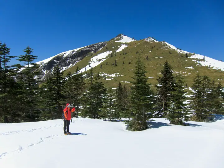
Mt. Neko (2,207 m) is an old volcano on the border of Ueda City and Suzaka City in Nagano, paired with Mt. Azumaya within Jōshin'etsu-Kōgen National Park. Its broad, grassy summit is renowned for alpine flowers such as ume-bachisō, komakusa, and willow herb, earning a place on Sumie Tanaka's "100 Flower Mountains." The mountain takes its name ("Cat Peak") from its silhouette beside Mt. Azumaya, said to resemble a pair of cat ears. The classic outing is a circuit from Sugadaira Pasture combining Mt. Neko and Mt. Azumaya, with summit views sweeping 360 degrees from the North Alps to the Asama Range and Shiga Highlands.
Mt. Neko at a glance
- Weather: The most settled day in the next 7 days is Wed, November 4: clear, gusts up to 6 m/s.
- Route: The shortest is Mount Nekodake Hiking Trail: about 2 h 36 min, 3.9 km, about 420 m of climbing.
Mt. Neko weather (hourly, 14 days)
Sunrise today 06:11, sunset 16:49
| Tue, 11/3 | Wed, 11/4 | Thu, 11/5 | Fri, 11/6 | Sat, 11/7 | Sun, 11/8 | Mon, 11/9 | Tue, 11/10 | Wed, 11/11 | Thu, 11/12 | Fri, 11/13 | Sat, 11/14 | Sun, 11/15 | Mon, 11/16 | Tue, 11/17 | |||||||||||||||||||||||||||||||||||||||||||||||||||||||||||||||||||||||
|---|---|---|---|---|---|---|---|---|---|---|---|---|---|---|---|---|---|---|---|---|---|---|---|---|---|---|---|---|---|---|---|---|---|---|---|---|---|---|---|---|---|---|---|---|---|---|---|---|---|---|---|---|---|---|---|---|---|---|---|---|---|---|---|---|---|---|---|---|---|---|---|---|---|---|---|---|---|---|---|---|---|---|---|---|---|
| Japan time | 15 | 17 | 19 | 21 | 23 | 1 | 3 | 5 | 7 | 9 | 11 | 13 | 15 | 18 | 21 | 0 | 3 | 6 | 9 | 12 | 15 | 18 | 21 | 0 | 3 | 6 | 9 | 12 | 15 | 18 | 21 | 0 | 3 | 6 | 9 | 12 | 15 | 18 | 21 | 0 | 3 | 6 | 9 | 12 | 15 | 18 | 21 | 0 | 3 | 6 | 9 | 15 | 21 | 3 | 9 | 15 | 21 | 3 | 9 | 15 | 21 | 3 | 9 | 15 | 21 | 3 | 9 | 15 | 21 | 3 | 9 | 15 | 21 | 3 | 9 | 15 | 21 | 3 | 9 | 15 | 21 | 3 | 9 | 15 | |
  |   | | | | | | |  | | | | |   | |   | | |   | | |   | | | |   | | | | | | | | | | |   | | | | | | | |   | | | |   | | | | | | | | |   |   | | | | | | | |   | | | | | |  | | | | |   | |   | | | | | ||
| Temperature | °C | 3° | 0° | -2° | -4° | -4° | -4° | -3° | -3° | -2° | 2° | 5° | 7° | 7° | 2° | 1° | 1° | 1° | 2° | 4° | 8° | 8° | 4° | 5° | 3° | 3° | 3° | 7° | 10° | 8° | 4° | 1° | 0° | -2° | -3° | -1° | 0° | -1° | -4° | -5° | -6° | -5° | -6° | -2° | 1° | -1° | -3° | -3° | -3° | -3° | -3° | 0° | 1° | -3° | -3° | 0° | 4° | -3° | -5° | -6° | -4° | -5° | -6° | -2° | 0° | -6° | -4° | -4° | -4° | -7° | -7° | -1° | 4° | -3° | -2° | 2° | 6° | 1° | 2° | 4° | 2° | -4° | -6° | -3° | 1° |
| Precipitation | mm | 0.8 | 10 | 5 | 1.6 | 0.9 | 0.3 | 0.1 | 0.1 | 0.2 | 0.2 | 0.2 | 0.2 | 1.7 | 2.9 | 2.5 | 0.2 | 1.0 | 0.6 | 5 | 6 | 0.7 | 0.3 | ||||||||||||||||||||||||||||||||||||||||||||||||||||||||||||||
| New snow | cm | <.1 | 0.8 | 2.9 | 2.2 | 0.1 | 0.4 | 0.2 | |||||||||||||||||||||||||||||||||||||||||||||||||||||||||||||||||||||||||||||
| Snow depth | cm | 0 | 0 | 0 | 0 | 0 | 0 | 0 | 0 | 0 | 0 | 0 | 0 | 0 | 0 | 0 | 0 | 0 | 0 | 0 | 0 | 0 | 0 | 0 | 0 | 0 | 0 | 0 | 0 | 0 | 0 | 0 | 0 | 0 | 0 | 0 | 0 | 0 | 0 | 0 | 0 | 0 | 0 | 0 | 0 | 0 | 0 | 0 | 0 | 0 | 0 | 0 | 0 | 0 | 0 | 0 | 0 | 0 | <1 | 2 | 2 | 2 | 2 | 2 | 1 | 1 | 1 | <1 | <1 | <1 | <1 | <1 | <1 | <1 | <1 | <1 | <1 | 0 | 0 | 0 | 0 | 0 | 0 | 0 | 0 |
| Wind | m/s | 3 | 2 | 1 | 1 | 1 | 1 | 1 | 1 | 1 | 1 | 1 | 1 | 1 | 2 | 2 | 2 | 2 | 1 | 1 | 1 | 1 | 1 | 0 | 1 | 0 | 0 | 2 | 3 | 2 | 1 | 1 | 1 | 1 | 1 | 3 | 3 | 3 | 2 | 1 | 2 | 3 | 3 | 2 | 3 | 4 | 2 | 1 | 1 | 1 | 1 | 0 | 3 | 2 | 1 | 1 | 3 | 1 | 4 | 3 | 4 | 3 | 1 | 1 | 2 | 1 | 1 | 3 | 4 | 3 | 1 | 1 | 1 | 1 | 1 | 1 | 2 | 2 | 3 | 2 | 4 | 4 | 2 | 1 | 2 |
| Wind gusts | m/s | 9 | 8 | 6 | 4 | 4 | 3 | 3 | 2 | 2 | 4 | 5 | 6 | 6 | 6 | 7 | 8 | 6 | 6 | 6 | 6 | 6 | 4 | 3 | 4 | 4 | 4 | 6 | 9 | 9 | 7 | 5 | 6 | 7 | 7 | 10 | 11 | 11 | 9 | 6 | 5 | 8 | 8 | 8 | 9 | 11 | 10 | 5 | 4 | 4 | 5 | 5 | 9 | 9 | 5 | 5 | 11 | 10 | 14 | 16 | 15 | 14 | 9 | 4 | 8 | 7 | 4 | 10 | 13 | 12 | 9 | 5 | 6 | 5 | 4 | 6 | 10 | 8 | 13 | 10 | 13 | 14 | 12 | 7 | 6 |
| Wind dir. | ↓ | ↓ | ↓ | ↓ | ↓ | ↓ | ↓ | ↓ | ↓ | ↓ | ↓ | ↓ | ↓ | ↓ | ↓ | ↓ | ↓ | ↓ | ↓ | ↓ | ↓ | ↓ | ↓ | ↓ | ↓ | ↓ | ↓ | ↓ | ↓ | ↓ | ↓ | ↓ | ↓ | ↓ | ↓ | ↓ | ↓ | ↓ | ↓ | ↓ | ↓ | ↓ | ↓ | ↓ | ↓ | ↓ | ↓ | ↓ | ↓ | ↓ | ↓ | ↓ | ↓ | ↓ | ↓ | ↓ | ↓ | ↓ | ↓ | ↓ | ↓ | ↓ | ↓ | ↓ | ↓ | ↓ | ↓ | ↓ | ↓ | ↓ | ↓ | ↓ | ↓ | ↓ | ↓ | ↓ | ↓ | ↓ | ↓ | ↓ | ↓ | ↓ | ↓ | ↓ | |
Mt. Neko hiking routes
- Mount Nekodake Hiking Trail 3.9 km · Ascent 424 m 根子岳避難小屋
- Mount Azumaya and Mount Nekodake Loop from Sugadaira Ranch 10.1 km · Ascent 998 m parking
Hiking times are estimates calculated from the terrain.
Huts, campsites and lodging near Mt. Neko
Mountain huts
Lodging
- Zukeran resort
- 菅平高原ホテル柄澤
Lists that include Mt. Neko
100 Famous Mountains of Flowers · Elevations of 1003 Mountains of Japan
Mt. Neko facts
- Elevation
- 2,207 m
- Location
- Ueda, Nagano
36.549121, 138.395280 - National Park
- 上信越高原国立公園
- Website
- sugadaira.com
- Trail Map
- www.pref.nagano.lg.jp (PDF)
- Wikipedia
- ja.wikipedia.org