
Mount Myoko (North Peak)
妙高山 北峰
Myōkō, Niigata · Elevation 2,446 m
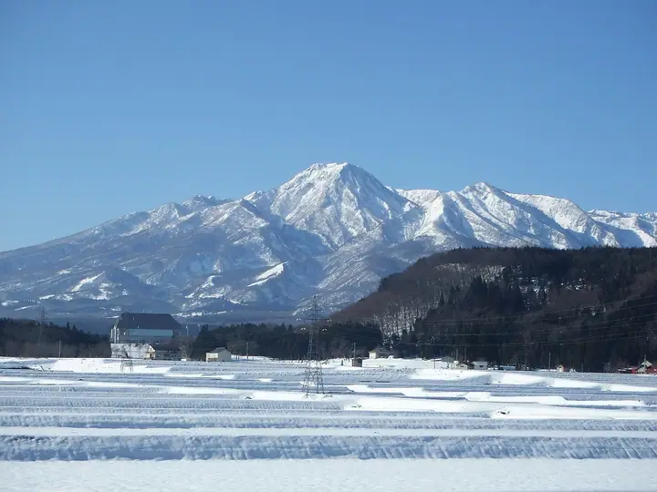
The North Peak of Mount Myoko, at 2,446 m, is part of the stratovolcano in Myoko, Niigata Prefecture; the South Peak is the highest point at 2,454 m. Mount Myoko is also known as Echigo Fuji and is a prominent mountain of Myoko-Togakushi Renzan National Park. Long revered as a mountain of worship, it is climbed from Seki and Tsubame hot springs and holds its opening ceremony each July 1.
Mount Myoko (North Peak) at a glance
- Weather: The most settled day in the next 7 days is Wed, November 4: clear, gusts up to 7 m/s.
- Route: The shortest is Mount Myoko via Kita Jigokudani from Tsubame Onsen: about 7 h 7 min, 10.9 km, about 1,380 m of climbing.
Mount Myoko (North Peak) weather (hourly, 14 days)
Sunrise today 06:13, sunset 16:50
| Tue, 11/3 | Wed, 11/4 | Thu, 11/5 | Fri, 11/6 | Sat, 11/7 | Sun, 11/8 | Mon, 11/9 | Tue, 11/10 | Wed, 11/11 | Thu, 11/12 | Fri, 11/13 | Sat, 11/14 | Sun, 11/15 | Mon, 11/16 | Tue, 11/17 | |||||||||||||||||||||||||||||||||||||||||||||||||||||||||||||||||||||||
|---|---|---|---|---|---|---|---|---|---|---|---|---|---|---|---|---|---|---|---|---|---|---|---|---|---|---|---|---|---|---|---|---|---|---|---|---|---|---|---|---|---|---|---|---|---|---|---|---|---|---|---|---|---|---|---|---|---|---|---|---|---|---|---|---|---|---|---|---|---|---|---|---|---|---|---|---|---|---|---|---|---|---|---|---|---|
| Japan time | 15 | 17 | 19 | 21 | 23 | 1 | 3 | 5 | 7 | 9 | 11 | 13 | 15 | 18 | 21 | 0 | 3 | 6 | 9 | 12 | 15 | 18 | 21 | 0 | 3 | 6 | 9 | 12 | 15 | 18 | 21 | 0 | 3 | 6 | 9 | 12 | 15 | 18 | 21 | 0 | 3 | 6 | 9 | 12 | 15 | 18 | 21 | 0 | 3 | 6 | 9 | 15 | 21 | 3 | 9 | 15 | 21 | 3 | 9 | 15 | 21 | 3 | 9 | 15 | 21 | 3 | 9 | 15 | 21 | 3 | 9 | 15 | 21 | 3 | 9 | 15 | 21 | 3 | 9 | 15 | 21 | 3 | 9 | 15 | |
  |   | |   | |   | |  |  | | |   | | | |   | | | |   |   | | | | | | |   | | | | | |   |   |   | |   |   | | | | |   | | | | | | |   | | | | | |   |   |   | | | | | | | | | | | | | |  | | | | | | | | | | | | ||
| Temperature | °C | -2° | -5° | -6° | -6° | -6° | -6° | -6° | -6° | -5° | -1° | 1° | 3° | 2° | -2° | -1° | -1° | -1° | -1° | 1° | 4° | 6° | 2° | 2° | 1° | 1° | 0° | 3° | 4° | 3° | -1° | -3° | -5° | -6° | -7° | -7° | -6° | -7° | -9° | -9° | -10° | -9° | -9° | -6° | -4° | -6° | -8° | -8° | -8° | -8° | -9° | -4° | -6° | -8° | -9° | -4° | 1° | -6° | -9° | -8° | -8° | -8° | -8° | -6° | -5° | -9° | -7° | -7° | -7° | -10° | -10° | -5° | -2° | -7° | -7° | -2° | 0° | -2° | -2° | 0° | -3° | -8° | -10° | -7° | -5° |
| Precipitation | mm | 0.2 | 0.4 | 8 | 5 | 2.7 | 2.1 | 0.4 | 1.3 | 0.1 | 0.4 | 0.8 | 0.5 | 1.4 | 1.9 | 1.3 | 0.6 | 0.4 | 0.3 | 0.4 | 0.9 | 0.7 | 0.5 | 0.2 | 0.3 | 1.3 | 1.4 | 0.1 | 0.5 | 0.1 | 0.2 | 3.2 | 11 | 8 | 1.8 | 0.2 | 0.5 | 0.1 | 16 | 6 | 0.2 | 10 | 4.9 | 2.5 | 11 | 10 | 0.7 | ||||||||||||||||||||||||||||||||||||||
| New snow | cm | <.1 | 0.5 | 0.3 | 0.2 | 0.1 | <.1 | <.1 | <.1 | 0.2 | 0.7 | 0.8 | <.1 | 1.9 | 11 | 6.1 | 1.3 | <.1 | <.1 | 10 | 3.8 | 0.1 | 3.3 | 0.4 | |||||||||||||||||||||||||||||||||||||||||||||||||||||||||||||
| Snow depth | cm | 0 | 0 | 0 | 0 | 0 | 0 | 0 | 0 | 0 | 0 | 0 | 0 | 0 | 0 | 0 | 0 | 0 | 0 | 0 | 0 | 0 | 0 | 0 | 0 | 0 | 0 | 0 | 0 | 0 | 0 | 0 | 0 | 0 | 0 | <1 | <1 | <1 | <1 | <1 | <1 | <1 | <1 | <1 | <1 | <1 | <1 | <1 | <1 | 1 | 1 | 1 | <1 | <1 | <1 | <1 | <1 | <1 | 2 | 9 | 10 | 10 | 10 | 9 | 7 | 7 | 7 | 13 | 14 | 13 | 13 | 13 | 11 | 11 | 10 | 10 | 8 | 7 | 6 | 6 | 4 | 6 | 6 | 6 | 5 |
| Wind | m/s | 3 | 2 | 1 | 2 | 1 | 1 | 1 | 1 | 1 | 1 | 2 | 2 | 1 | 2 | 3 | 2 | 2 | 2 | 2 | 2 | 0 | 0 | 0 | 0 | 1 | 1 | 1 | 1 | 1 | 1 | 1 | 2 | 2 | 2 | 2 | 3 | 3 | 2 | 2 | 2 | 2 | 2 | 2 | 3 | 3 | 2 | 1 | 1 | 1 | 1 | 0 | 3 | 2 | 0 | 3 | 2 | 1 | 2 | 3 | 3 | 1 | 0 | 0 | 2 | 1 | 1 | 2 | 2 | 2 | 0 | 0 | 1 | 1 | 1 | 2 | 0 | 2 | 2 | 2 | 3 | 3 | 2 | 1 | 2 |
| Wind gusts | m/s | 10 | 9 | 7 | 6 | 6 | 5 | 5 | 4 | 4 | 5 | 7 | 7 | 7 | 7 | 11 | 11 | 10 | 10 | 9 | 8 | 8 | 4 | 3 | 4 | 4 | 6 | 7 | 7 | 7 | 7 | 7 | 9 | 9 | 10 | 11 | 13 | 13 | 12 | 10 | 10 | 10 | 10 | 8 | 10 | 11 | 9 | 6 | 6 | 6 | 6 | 6 | 10 | 9 | 6 | 9 | 11 | 8 | 14 | 18 | 17 | 12 | 6 | 3 | 8 | 7 | 7 | 9 | 11 | 10 | 8 | 5 | 6 | 5 | 5 | 7 | 7 | 9 | 11 | 8 | 13 | 13 | 10 | 6 | 7 |
| Wind dir. | ↓ | ↓ | ↓ | ↓ | ↓ | ↓ | ↓ | ↓ | ↓ | ↓ | ↓ | ↓ | ↓ | ↓ | ↓ | ↓ | ↓ | ↓ | ↓ | ↓ | ↓ | ↓ | ↓ | ↓ | ↓ | ↓ | ↓ | ↓ | ↓ | ↓ | ↓ | ↓ | ↓ | ↓ | ↓ | ↓ | ↓ | ↓ | ↓ | ↓ | ↓ | ↓ | ↓ | ↓ | ↓ | ↓ | ↓ | ↓ | ↓ | ↓ | ↓ | ↓ | ↓ | ↓ | ↓ | ↓ | ↓ | ↓ | ↓ | ↓ | ↓ | ↓ | ↓ | ↓ | ↓ | ↓ | ↓ | ↓ | ↓ | ↓ | ↓ | ↓ | ↓ | ↓ | ↓ | ↓ | ↓ | ↓ | ↓ | ↓ | ↓ | ↓ | ↓ | ||
Mount Myoko (North Peak) hiking routes
- Mount Myoko via Kita Jigokudani from Tsubame Onsen 10.9 km · Ascent 1,382 m parking
- Mount Hiuchi and Mount Myoko Circuit from Sasagamine 24.3 km · Ascent 2,114 m 笹ヶ峰登山口 (parking)
Hiking times are estimates calculated from the terrain.
Huts, campsites and lodging near Mount Myoko (North Peak)
Mountain huts
- 大谷ヒュッテ (南地獄谷避難小屋) unstaffed
- Kurosawaike hut 2026: open July 1–October 31 · sleeps 100
- Koyaike Hutte 2026: open May 1–October 25 · reservation required · sleeps 40
- 京大ヒュッテ 2026: open August 1–October 12 · reservation required · sleeps 20
- 笹ヶ峰ロッジ
Lodging
- 山の湯宿針村屋
- 燕温泉 ホテル岩戸屋
- 燕温泉 樺太館
- Hanabun Onsen Hotel
- Tsubame Highland Lodge
Mount Myoko (North Peak) facts
- Elevation
- 2,446 m
- Location
- Myōkō, Niigata
36.892741, 138.113176 - National Park
- 妙高戸隠連山国立公園
- Volcano
- Active volcano (妙高山)
- Season Opens
- July 1
- Website
- niigata-kankou.or.jp
- Wikipedia
- ja.wikipedia.org