
Mount Kurohime
黒姫山
Shinano, Nagano · Elevation 2,053 m
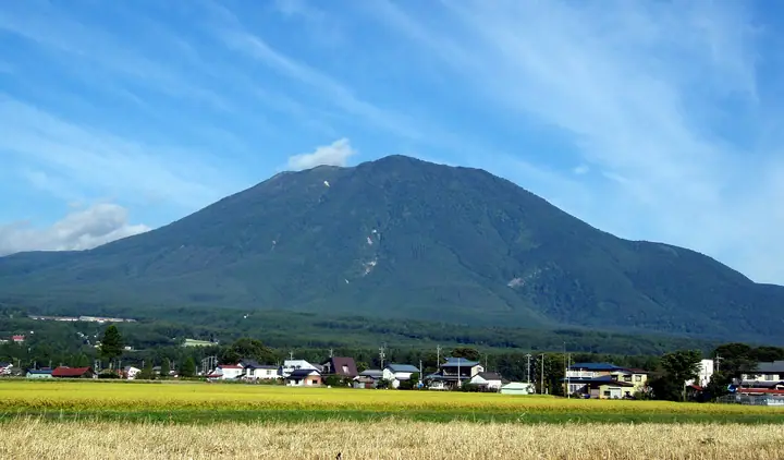
Mount Kurohime is a 2,053 m double stratovolcano in Shinano Town (Kami-Minochi District), Nagano Prefecture, and one of the Five Peaks of Hokushin alongside Togakushi, Iizuna, Myōkō, and Madarao. Its symmetrical cone earns it the nickname "Shinano Fuji," and the summit is part of an outer rim enclosing a crater plain that holds the central peak of Ko-Kurohime — a textbook conical-with-central-cone profile. Set within Myōkō-Togakushi-Renzan National Park, it appears in the Nihon Nihyaku Meizan, the Shinshū Hyakumeizan, and the trio of "Nihon San-Kurohime" peaks. The principal trails are the Koizumi route from Kurohime Ski Resort and the Omote-tozandō from Akashibu via Chōmin-no-Mori on the Shinano-machi side, and the Furu-ike / Nishi-tozandō from Togakushi; linking the two makes a half-loop of the crater rim. The summit ridge commands views of the Togakushi range, the Northern Alps, and Mount Myōkō, with autumn colour peaking in early to mid-October.
Mount Kurohime at a glance
- Weather: The most settled day in the next 7 days is Wed, November 4: clear, gusts up to 7 m/s.
- Route: The shortest is Mount Kurohime via the Ohashi Trail: about 6 h 37 min, 12.5 km, about 960 m of climbing.
Mount Kurohime weather (hourly, 14 days)
Sunrise today 06:12, sunset 16:50
| Tue, 11/3 | Wed, 11/4 | Thu, 11/5 | Fri, 11/6 | Sat, 11/7 | Sun, 11/8 | Mon, 11/9 | Tue, 11/10 | Wed, 11/11 | Thu, 11/12 | Fri, 11/13 | Sat, 11/14 | Sun, 11/15 | Mon, 11/16 | Tue, 11/17 | |||||||||||||||||||||||||||||||||||||||||||||||||||||||||||||||||||||||
|---|---|---|---|---|---|---|---|---|---|---|---|---|---|---|---|---|---|---|---|---|---|---|---|---|---|---|---|---|---|---|---|---|---|---|---|---|---|---|---|---|---|---|---|---|---|---|---|---|---|---|---|---|---|---|---|---|---|---|---|---|---|---|---|---|---|---|---|---|---|---|---|---|---|---|---|---|---|---|---|---|---|---|---|---|---|
| Japan time | 15 | 17 | 19 | 21 | 23 | 1 | 3 | 5 | 7 | 9 | 11 | 13 | 15 | 18 | 21 | 0 | 3 | 6 | 9 | 12 | 15 | 18 | 21 | 0 | 3 | 6 | 9 | 12 | 15 | 18 | 21 | 0 | 3 | 6 | 9 | 12 | 15 | 18 | 21 | 0 | 3 | 6 | 9 | 12 | 15 | 18 | 21 | 0 | 3 | 6 | 9 | 15 | 21 | 3 | 9 | 15 | 21 | 3 | 9 | 15 | 21 | 3 | 9 | 15 | 21 | 3 | 9 | 15 | 21 | 3 | 9 | 15 | 21 | 3 | 9 | 15 | 21 | 3 | 9 | 15 | 21 | 3 | 9 | 15 | |
  |   | |   | |   | |  |  | | |   | | | |   | | | |   |   | | | | | | |   | | | | | |   |   |   | |   |   | | | | |   | | | | | | |   | | | | | |   |   |   | | | | | | | | | | | | | |  | | | | | | | | | | | | ||
| Temperature | °C | 1° | -2° | -3° | -4° | -4° | -3° | -4° | -4° | -2° | 1° | 4° | 5° | 5° | 1° | 2° | 1° | 1° | 2° | 3° | 6° | 8° | 4° | 4° | 3° | 3° | 2° | 5° | 6° | 5° | 1° | -1° | -2° | -4° | -5° | -5° | -3° | -4° | -6° | -7° | -7° | -7° | -6° | -4° | -2° | -3° | -6° | -6° | -5° | -6° | -6° | -1° | -3° | -5° | -6° | -1° | 3° | -3° | -7° | -5° | -5° | -5° | -6° | -4° | -3° | -6° | -4° | -5° | -5° | -7° | -7° | -2° | 1° | -4° | -4° | 1° | 3° | 0° | 0° | 2° | -1° | -5° | -7° | -4° | -2° |
| Precipitation | mm | 0.2 | 0.4 | 8 | 5 | 2.7 | 2.1 | 0.4 | 1.3 | 0.1 | 0.4 | 0.8 | 0.5 | 1.4 | 1.9 | 1.3 | 0.6 | 0.4 | 0.3 | 0.4 | 0.9 | 0.7 | 0.5 | 0.2 | 0.3 | 1.3 | 1.4 | 0.1 | 0.5 | 0.1 | 0.2 | 3.2 | 11 | 8 | 1.8 | 0.2 | 0.5 | 0.1 | 16 | 6 | 0.2 | 10 | 4.9 | 2.5 | 11 | 10 | 0.7 | ||||||||||||||||||||||||||||||||||||||
| New snow | cm | <.1 | 0.5 | 0.3 | 0.2 | 0.1 | <.1 | <.1 | <.1 | 0.2 | 0.7 | 0.8 | <.1 | 1.9 | 11 | 6.1 | 1.3 | <.1 | <.1 | 10 | 3.8 | 0.1 | 3.3 | 0.4 | |||||||||||||||||||||||||||||||||||||||||||||||||||||||||||||
| Snow depth | cm | 0 | 0 | 0 | 0 | 0 | 0 | 0 | 0 | 0 | 0 | 0 | 0 | 0 | 0 | 0 | 0 | 0 | 0 | 0 | 0 | 0 | 0 | 0 | 0 | 0 | 0 | 0 | 0 | 0 | 0 | 0 | 0 | 0 | 0 | <1 | <1 | <1 | <1 | <1 | <1 | <1 | <1 | <1 | <1 | <1 | <1 | <1 | <1 | 1 | 1 | 1 | <1 | <1 | <1 | <1 | <1 | <1 | 2 | 9 | 10 | 10 | 10 | 9 | 7 | 7 | 7 | 13 | 14 | 13 | 13 | 13 | 11 | 11 | 10 | 10 | 8 | 7 | 6 | 6 | 4 | 6 | 6 | 6 | 5 |
| Wind | m/s | 3 | 2 | 1 | 2 | 1 | 1 | 1 | 1 | 1 | 1 | 2 | 2 | 1 | 2 | 3 | 2 | 2 | 2 | 2 | 2 | 0 | 0 | 0 | 0 | 1 | 1 | 1 | 1 | 1 | 1 | 1 | 2 | 2 | 2 | 2 | 3 | 3 | 2 | 2 | 2 | 2 | 2 | 2 | 3 | 3 | 2 | 1 | 1 | 1 | 1 | 0 | 3 | 2 | 0 | 3 | 2 | 1 | 2 | 3 | 3 | 1 | 0 | 0 | 2 | 1 | 1 | 2 | 2 | 2 | 0 | 0 | 1 | 1 | 1 | 2 | 0 | 2 | 2 | 2 | 3 | 3 | 2 | 1 | 2 |
| Wind gusts | m/s | 10 | 9 | 7 | 6 | 6 | 5 | 5 | 4 | 4 | 5 | 7 | 7 | 7 | 7 | 11 | 11 | 10 | 10 | 9 | 8 | 8 | 4 | 3 | 4 | 4 | 6 | 7 | 7 | 7 | 7 | 7 | 9 | 9 | 10 | 11 | 13 | 13 | 12 | 10 | 10 | 10 | 10 | 8 | 10 | 11 | 9 | 6 | 6 | 6 | 6 | 6 | 10 | 9 | 6 | 9 | 11 | 8 | 14 | 18 | 17 | 12 | 6 | 3 | 8 | 7 | 7 | 9 | 11 | 10 | 8 | 5 | 6 | 5 | 5 | 7 | 7 | 9 | 11 | 8 | 13 | 13 | 10 | 6 | 7 |
| Wind dir. | ↓ | ↓ | ↓ | ↓ | ↓ | ↓ | ↓ | ↓ | ↓ | ↓ | ↓ | ↓ | ↓ | ↓ | ↓ | ↓ | ↓ | ↓ | ↓ | ↓ | ↓ | ↓ | ↓ | ↓ | ↓ | ↓ | ↓ | ↓ | ↓ | ↓ | ↓ | ↓ | ↓ | ↓ | ↓ | ↓ | ↓ | ↓ | ↓ | ↓ | ↓ | ↓ | ↓ | ↓ | ↓ | ↓ | ↓ | ↓ | ↓ | ↓ | ↓ | ↓ | ↓ | ↓ | ↓ | ↓ | ↓ | ↓ | ↓ | ↓ | ↓ | ↓ | ↓ | ↓ | ↓ | ↓ | ↓ | ↓ | ↓ | ↓ | ↓ | ↓ | ↓ | ↓ | ↓ | ↓ | ↓ | ↓ | ↓ | ↓ | ↓ | ↓ | ↓ | ||
Mount Kurohime hiking routes
Hiking times are estimates calculated from the terrain.
Huts, campsites and lodging near Mount Kurohime
Mountain huts
- 氷沢避難小屋
Lists that include Mount Kurohime
Japan 200 Famous Mountains · Japan's 300 Famous Mountains · 100 Fujis of Japan · Koshinetsu 100 Famous Mountains · Shinshu 100 Famous Mountains · Five Mountains of Northern Shinshu · Elevations of 1003 Mountains of Japan · 1000 Mountains of Japan
Mount Kurohime facts
- Also known as
- 信濃富士
- Elevation
- 2,053 m
- Location
- Shinano, Nagano
36.813378, 138.127204 - National Park
- 妙高戸隠連山国立公園
- Website
- www.shinano-machi.com
- Trail Map
- www.shinano-machi.com (PDF)
- Access Information
- www.shinano-machi.com
- Wikipedia
- ja.wikipedia.org