
Mt. Reisenjisan
霊仙寺山
Shinano, Nagano · Elevation 1,875 m
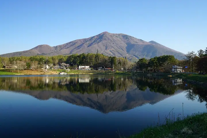
Mt. Reisenjisan is an 1,875 m peak straddling Nagano City, Iizuna Town and Shinano Town in northern Nagano Prefecture, rising as a subsidiary summit of neighbouring Mt. Iizunayama (1,917 m); the ridge as a whole is often referred to collectively as Iizuna. The mountain forms part of the Iizuna volcanic group — one of the Hokushin Gogaku (Five Peaks of Northern Shinshū) — and has been climbed since antiquity as a site of mountain worship and Shugendō ascetic practice, alongside Mt. Togakushi. It lies within Myōkō-Togakushi Renzan National Park, and the Shinshū Mountain Guide (in cooperation with the Nagano Prefectural Mountaineering Association) documents an approach from Reisenji Lake and the Iizuna Higashi-Kōgen highland.
Mt. Reisenjisan at a glance
- Weather: The most settled day in the next 7 days is Wed, November 4: clear, gusts up to 6 m/s.
Mt. Reisenjisan weather (hourly, 14 days)
Sunrise today 06:12, sunset 16:50
| Tue, 11/3 | Wed, 11/4 | Thu, 11/5 | Fri, 11/6 | Sat, 11/7 | Sun, 11/8 | Mon, 11/9 | Tue, 11/10 | Wed, 11/11 | Thu, 11/12 | Fri, 11/13 | Sat, 11/14 | Sun, 11/15 | Mon, 11/16 | Tue, 11/17 | |||||||||||||||||||||||||||||||||||||||||||||||||||||||||||||||||||||||
|---|---|---|---|---|---|---|---|---|---|---|---|---|---|---|---|---|---|---|---|---|---|---|---|---|---|---|---|---|---|---|---|---|---|---|---|---|---|---|---|---|---|---|---|---|---|---|---|---|---|---|---|---|---|---|---|---|---|---|---|---|---|---|---|---|---|---|---|---|---|---|---|---|---|---|---|---|---|---|---|---|---|---|---|---|---|
| Japan time | 21 | 23 | 1 | 3 | 5 | 7 | 9 | 11 | 13 | 15 | 17 | 19 | 21 | 0 | 3 | 6 | 9 | 12 | 15 | 18 | 21 | 0 | 3 | 6 | 9 | 12 | 15 | 18 | 21 | 0 | 3 | 6 | 9 | 12 | 15 | 18 | 21 | 0 | 3 | 6 | 9 | 12 | 15 | 18 | 21 | 0 | 3 | 6 | 9 | 12 | 15 | 21 | 3 | 9 | 15 | 21 | 3 | 9 | 15 | 21 | 3 | 9 | 15 | 21 | 3 | 9 | 15 | 21 | 3 | 9 | 15 | 21 | 3 | 9 | 15 | 21 | 3 | 9 | 15 | 21 | 3 | 9 | 15 | 21 | |
  | | |   | |   |  | | | | |   | |   | | |   | |   | |   | | | |   | | | | |   | | | | |   |   | | | | |   | |   | | | | | | | | | | | | | |   |   | |   | | | |  | | |   | | | | | | | | | | | | |   | | | | | ||
| Temperature | °C | -2° | -3° | -3° | -3° | -3° | -1° | 3° | 6° | 7° | 7° | 4° | 4° | 4° | 3° | 3° | 3° | 6° | 9° | 8° | 7° | 6° | 5° | 5° | 5° | 7° | 10° | 10° | 4° | 2° | 1° | -1° | -1° | 1° | 1° | 0° | -3° | -3° | -3° | -3° | -3° | 0° | 2° | 0° | -3° | -3° | -3° | -2° | -2° | 3° | 7° | 3° | -2° | -3° | 1° | 6° | 0° | -3° | -2° | -1° | -3° | -3° | -1° | 1° | -5° | -3° | -1° | 0° | -4° | -4° | 0° | 5° | -2° | -2° | 3° | 6° | 3° | 3° | 5° | 3° | -2° | -4° | -1° | 2° | -5° |
| Precipitation | mm | 1.8 | 8 | 2.7 | 0.3 | 0.3 | 1.8 | 3.4 | 2.0 | 2.4 | 0.9 | 0.3 | 0.3 | 0.9 | 0.5 | 0.8 | 1.4 | 0.9 | 0.8 | 0.1 | 1.2 | 8 | 6 | 0.6 | 0.5 | 0.2 | 7 | 2.8 | 7 | 5 | 0.9 | 2.6 | 4.1 | 0.2 | |||||||||||||||||||||||||||||||||||||||||||||||||||
| New snow | cm | <.1 | <.1 | <.1 | <.1 | <.1 | 0.3 | 4.7 | 2.9 | 0.3 | 2.1 | 0.9 | <.1 | 0.5 | <.1 | ||||||||||||||||||||||||||||||||||||||||||||||||||||||||||||||||||||||
| Snow depth | cm | 0 | 0 | 0 | 0 | 0 | 0 | 0 | 0 | 0 | 0 | 0 | 0 | 0 | 0 | 0 | 0 | 0 | 0 | 0 | 0 | 0 | 0 | 0 | 0 | 0 | 0 | 0 | 0 | 0 | 0 | 0 | 0 | 0 | 0 | 0 | 0 | 0 | 0 | 0 | 0 | 0 | 0 | 0 | 0 | 0 | 0 | <1 | <1 | <1 | <1 | 0 | 0 | 0 | 0 | 0 | 0 | <1 | 3 | 4 | 4 | 4 | 4 | 3 | 2 | 2 | 3 | 3 | 3 | 3 | 3 | 2 | 2 | 2 | 2 | 1 | <1 | <1 | <1 | 0 | <1 | <1 | <1 | 0 | 0 |
| Wind | m/s | 2 | 2 | 2 | 1 | 1 | 1 | 1 | 2 | 1 | 0 | 2 | 3 | 3 | 2 | 2 | 2 | 2 | 1 | 1 | 0 | 1 | 1 | 1 | 1 | 0 | 1 | 0 | 1 | 2 | 2 | 2 | 0 | 1 | 1 | 1 | 1 | 1 | 2 | 2 | 1 | 1 | 3 | 3 | 2 | 2 | 1 | 1 | 1 | 0 | 3 | 3 | 2 | 1 | 2 | 2 | 1 | 2 | 1 | 1 | 0 | 1 | 1 | 2 | 1 | 1 | 1 | 3 | 1 | 1 | 1 | 2 | 1 | 2 | 2 | 1 | 2 | 2 | 2 | 3 | 2 | 1 | 1 | 3 | 1 |
| Wind gusts | m/s | 5 | 6 | 5 | 5 | 4 | 3 | 4 | 6 | 6 | 6 | 5 | 8 | 9 | 9 | 7 | 7 | 7 | 7 | 6 | 4 | 4 | 5 | 5 | 4 | 5 | 7 | 7 | 6 | 5 | 5 | 6 | 6 | 6 | 7 | 8 | 7 | 5 | 6 | 6 | 6 | 6 | 8 | 9 | 8 | 5 | 5 | 5 | 4 | 5 | 8 | 9 | 9 | 6 | 6 | 9 | 7 | 10 | 11 | 11 | 7 | 4 | 4 | 8 | 7 | 6 | 6 | 9 | 9 | 5 | 5 | 6 | 6 | 5 | 7 | 7 | 6 | 8 | 7 | 11 | 11 | 7 | 5 | 8 | 7 |
| Wind dir. | ↓ | ↓ | ↓ | ↓ | ↓ | ↓ | ↓ | ↓ | ↓ | ↓ | ↓ | ↓ | ↓ | ↓ | ↓ | ↓ | ↓ | ↓ | ↓ | ↓ | ↓ | ↓ | ↓ | ↓ | ↓ | ↓ | ↓ | ↓ | ↓ | ↓ | ↓ | ↓ | ↓ | ↓ | ↓ | ↓ | ↓ | ↓ | ↓ | ↓ | ↓ | ↓ | ↓ | ↓ | ↓ | ↓ | ↓ | ↓ | ↓ | ↓ | ↓ | ↓ | ↓ | ↓ | ↓ | ↓ | ↓ | ↓ | ↓ | ↓ | ↓ | ↓ | ↓ | ↓ | ↓ | ↓ | ↓ | ↓ | ↓ | ↓ | ↓ | ↓ | ↓ | ↓ | ↓ | ↓ | ↓ | ↓ | ↓ | ↓ | ↓ | ↓ | ↓ | ↓ | |
Huts, campsites and lodging near Mt. Reisenjisan
Campsites
- Togakushi Eastern Camping Ground
Lodging
- Pension Himawari Lizuna
- 戸隠高原ホテル
- 民宿 りんどう
- とがくし屋
- 民宿 飯綱館
Mt. Reisenjisan facts
- Elevation
- 1,875 m
- Location
- Shinano, Nagano
36.748530, 138.140121 - National Park
- 妙高戸隠連山国立公園
- Wikipedia
- ja.wikipedia.org