
Mount Togakushi
戸隠山
Nagano, Nagano · Elevation 1,904 m
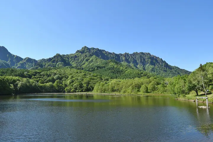
Mount Togakushi (1,904 m) is a serrated rock ridge in northern Nagano City, Nagano Prefecture, within Myōkō-Togakushi Renzan National Park. Long revered as a Shugendō sacred mountain associated with Togakushi Shrine, it features knife-edge sections such as Ari-no-tōwatari and Tsurugi-no-hawatari that demand technical scrambling. The peak is listed among the 200 Famous Mountains of Japan, the 100 Mountains of Flowers, and the Five Peaks of Northern Shinano.
Mount Togakushi at a glance
- Weather: The most settled day in the next 7 days is Wed, November 4: clear, gusts up to 7 m/s.
- Route: The shortest is Mount Togakushi and Mount Kuzuryu Loop from Togakushi Campground: about 6 h 23 min, 11.1 km, about 980 m of climbing.
Mount Togakushi weather (hourly, 14 days)
Sunrise today 06:13, sunset 16:50
| Tue, 11/3 | Wed, 11/4 | Thu, 11/5 | Fri, 11/6 | Sat, 11/7 | Sun, 11/8 | Mon, 11/9 | Tue, 11/10 | Wed, 11/11 | Thu, 11/12 | Fri, 11/13 | Sat, 11/14 | Sun, 11/15 | Mon, 11/16 | Tue, 11/17 | |||||||||||||||||||||||||||||||||||||||||||||||||||||||||||||||||||||||
|---|---|---|---|---|---|---|---|---|---|---|---|---|---|---|---|---|---|---|---|---|---|---|---|---|---|---|---|---|---|---|---|---|---|---|---|---|---|---|---|---|---|---|---|---|---|---|---|---|---|---|---|---|---|---|---|---|---|---|---|---|---|---|---|---|---|---|---|---|---|---|---|---|---|---|---|---|---|---|---|---|---|---|---|---|---|
| Japan time | 21 | 23 | 1 | 3 | 5 | 7 | 9 | 11 | 13 | 15 | 17 | 19 | 21 | 0 | 3 | 6 | 9 | 12 | 15 | 18 | 21 | 0 | 3 | 6 | 9 | 12 | 15 | 18 | 21 | 0 | 3 | 6 | 9 | 12 | 15 | 18 | 21 | 0 | 3 | 6 | 9 | 12 | 15 | 18 | 21 | 0 | 3 | 6 | 9 | 12 | 15 | 21 | 3 | 9 | 15 | 21 | 3 | 9 | 15 | 21 | 3 | 9 | 15 | 21 | 3 | 9 | 15 | 21 | 3 | 9 | 15 | 21 | 3 | 9 | 15 | 21 | 3 | 9 | 15 | 21 | 3 | 9 | 15 | 21 | |
  |   | | |   |   |  | | | | | | |   | | |   |   |   | |   | | | | | | | | | | |   | |   |   |   | | | | | | |   | | | | | | | | | | | | | |   |   | | | | | |  | | | | | | | | | | | | | |   | |   | | | | | ||
| Temperature | °C | -3° | -3° | -3° | -3° | -3° | -2° | 3° | 6° | 7° | 6° | 3° | 3° | 3° | 3° | 3° | 3° | 6° | 8° | 8° | 7° | 6° | 6° | 5° | 5° | 7° | 10° | 9° | 5° | 3° | 1° | -1° | -1° | 1° | 2° | 1° | -3° | -3° | -4° | -4° | -4° | -1° | 1° | -1° | -4° | -3° | -3° | -2° | -1° | 3° | 7° | 3° | -2° | -3° | 1° | 5° | 0° | -4° | -3° | -3° | -4° | -5° | -2° | 0° | -5° | -3° | -2° | -2° | -6° | -6° | 0° | 5° | -2° | -2° | 3° | 6° | 3° | 3° | 5° | 2° | -3° | -5° | -2° | 2° | -6° |
| Precipitation | mm | 1.8 | 7 | 3.4 | 0.3 | 0.6 | 2.2 | 4.2 | 1.0 | 0.2 | 0.2 | 0.2 | 0.1 | 0.2 | 0.2 | 0.3 | 2.2 | 9 | 6 | 1.0 | 7 | 2.3 | 0.2 | 9 | 6 | 1.0 | 2.8 | 4.2 | 0.3 | ||||||||||||||||||||||||||||||||||||||||||||||||||||||||
| New snow | cm | <.1 | <.1 | <.1 | <.1 | <.1 | 0.1 | <.1 | 1.0 | 8.7 | 5.6 | 0.8 | 2.8 | 1.2 | <.1 | 1.0 | 0.1 | ||||||||||||||||||||||||||||||||||||||||||||||||||||||||||||||||||||
| Snow depth | cm | 0 | 0 | 0 | 0 | 0 | 0 | 0 | 0 | 0 | 0 | 0 | 0 | 0 | 0 | 0 | 0 | 0 | 0 | 0 | 0 | 0 | 0 | 0 | 0 | 0 | 0 | 0 | 0 | 0 | 0 | 0 | 0 | 0 | 0 | 0 | 0 | 0 | 0 | 0 | 0 | 0 | 0 | 0 | 0 | 0 | 0 | <1 | <1 | <1 | <1 | 0 | 0 | 0 | 0 | 0 | 0 | <1 | 6 | 8 | 8 | 8 | 7 | 5 | 4 | 4 | 6 | 5 | 5 | 5 | 5 | 4 | 4 | 4 | 4 | 3 | 2 | 2 | 2 | <1 | 1 | 1 | 1 | <1 | <1 |
| Wind | m/s | 2 | 2 | 2 | 2 | 1 | 1 | 1 | 2 | 2 | 1 | 1 | 2 | 2 | 1 | 1 | 1 | 1 | 1 | 1 | 0 | 1 | 0 | 2 | 2 | 1 | 2 | 3 | 2 | 2 | 2 | 2 | 2 | 2 | 2 | 2 | 2 | 2 | 3 | 3 | 2 | 2 | 2 | 3 | 1 | 1 | 0 | 0 | 0 | 0 | 1 | 3 | 2 | 1 | 1 | 1 | 1 | 1 | 3 | 2 | 2 | 1 | 0 | 2 | 1 | 2 | 2 | 3 | 2 | 2 | 1 | 1 | 0 | 1 | 1 | 0 | 1 | 1 | 3 | 3 | 2 | 1 | 1 | 2 | 0 |
| Wind gusts | m/s | 6 | 6 | 5 | 5 | 5 | 4 | 4 | 6 | 7 | 6 | 5 | 7 | 7 | 7 | 6 | 5 | 6 | 5 | 5 | 4 | 4 | 4 | 6 | 6 | 6 | 8 | 9 | 9 | 8 | 6 | 8 | 8 | 7 | 8 | 9 | 8 | 8 | 8 | 9 | 9 | 7 | 8 | 9 | 8 | 4 | 4 | 4 | 4 | 4 | 6 | 8 | 8 | 5 | 5 | 8 | 6 | 13 | 14 | 12 | 9 | 6 | 4 | 8 | 8 | 6 | 9 | 10 | 10 | 8 | 5 | 5 | 4 | 3 | 5 | 7 | 6 | 7 | 8 | 12 | 12 | 8 | 5 | 6 | 5 |
| Wind dir. | ↓ | ↓ | ↓ | ↓ | ↓ | ↓ | ↓ | ↓ | ↓ | ↓ | ↓ | ↓ | ↓ | ↓ | ↓ | ↓ | ↓ | ↓ | ↓ | ↓ | ↓ | ↓ | ↓ | ↓ | ↓ | ↓ | ↓ | ↓ | ↓ | ↓ | ↓ | ↓ | ↓ | ↓ | ↓ | ↓ | ↓ | ↓ | ↓ | ↓ | ↓ | ↓ | ↓ | ↓ | ↓ | ↓ | ↓ | ↓ | ↓ | ↓ | ↓ | ↓ | ↓ | ↓ | ↓ | ↓ | ↓ | ↓ | ↓ | ↓ | ↓ | ↓ | ↓ | ↓ | ↓ | ↓ | ↓ | ↓ | ↓ | ↓ | ↓ | ↓ | ↓ | ↓ | ↓ | ↓ | ↓ | ↓ | ↓ | ↓ | ↓ | ↓ | ↓ | ↓ | |
Mount Togakushi hiking routes
Hiking times are estimates calculated from the terrain.
Huts, campsites and lodging near Mount Togakushi
Mountain huts
Campsites
- 戸隠キャンプ場
- Togakushi Campground Welcome House
- Togakushi Eastern Camping Ground
- 品沢高原キャンプ場
Lodging
- 戸隠高原ホテル
- 民宿 やまかね荘
- とがくし屋
- 民宿 飯綱館
- 民宿 りんどう
Lists that include Mount Togakushi
Japan 200 Famous Mountains · Japan's 300 Famous Mountains · 100 Famous Mountains of Flowers · Illustrated Collection of Japan's Famous Mountains · Koshinetsu 100 Famous Mountains · Shinshu 100 Famous Mountains · Shinshu Mountain Cards · Five Mountains of Northern Shinshu · Elevations of 1003 Mountains of Japan · 1000 Mountains of Japan
Mount Togakushi facts
- Elevation
- 1,904 m
- Location
- Nagano, Nagano
36.770436, 138.055138 - National Park
- 妙高戸隠連山国立公園
- Website
- togakushi-21.jp
- Trail Map
- www.city.nagano.nagano.jp (PDF)
- Access Information
- www.togakushi-jinja.jp
- Wikipedia
- ja.wikipedia.org