
Mount Kengamine
剣ヶ峰
Takayama, Gifu · Elevation 3,026 m
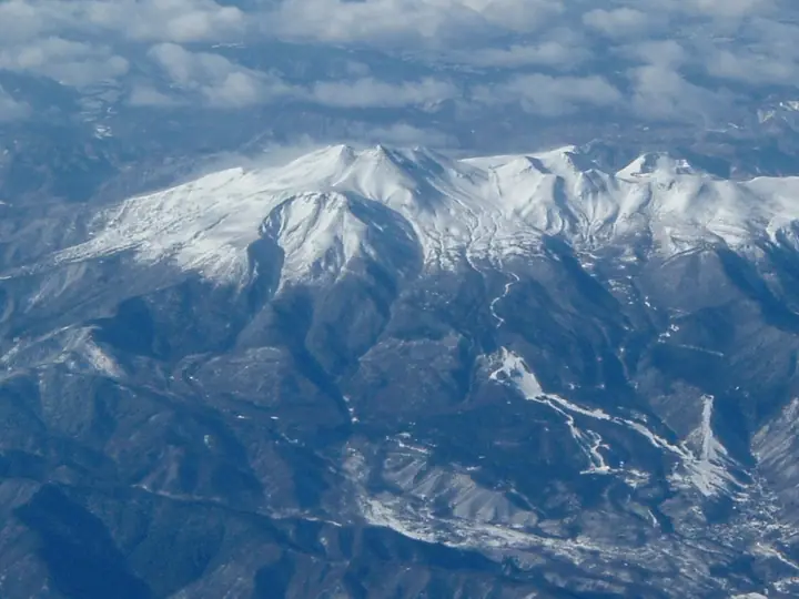
Kengamine is Mount Norikura’s highest summit. It is about a 90-minute climb from Tatamidaira bus terminal. The summit overlooks Yarigatake, the Hotaka range, Yatsugatake and the Southern and Central Alps; the top of Mount Fuji is also visible in clear weather.
Mount Kengamine at a glance
- Weather: The most settled day in the next 7 days is Wed, November 4: clear, gusts up to 9 m/s. Sat, Nov 7: strong wind (gusts up to 19 m/s).
- Route: The shortest is Mount Norikura Kengamine Out-and-Back from Tatamidaira: about 2 h 48 min, 5.7 km, about 390 m of climbing.
Mount Kengamine weather (hourly, 14 days)
Sunrise today 06:14, sunset 16:53
| Tue, 11/3 | Wed, 11/4 | Thu, 11/5 | Fri, 11/6 | Sat, 11/7 | Sun, 11/8 | Mon, 11/9 | Tue, 11/10 | Wed, 11/11 | Thu, 11/12 | Fri, 11/13 | Sat, 11/14 | Sun, 11/15 | Mon, 11/16 | Tue, 11/17 | |||||||||||||||||||||||||||||||||||||||||||||||||||||||||||||||||||||||
|---|---|---|---|---|---|---|---|---|---|---|---|---|---|---|---|---|---|---|---|---|---|---|---|---|---|---|---|---|---|---|---|---|---|---|---|---|---|---|---|---|---|---|---|---|---|---|---|---|---|---|---|---|---|---|---|---|---|---|---|---|---|---|---|---|---|---|---|---|---|---|---|---|---|---|---|---|---|---|---|---|---|---|---|---|---|
| Japan time | 15 | 17 | 19 | 21 | 23 | 1 | 3 | 5 | 7 | 9 | 11 | 13 | 15 | 18 | 21 | 0 | 3 | 6 | 9 | 12 | 15 | 18 | 21 | 0 | 3 | 6 | 9 | 12 | 15 | 18 | 21 | 0 | 3 | 6 | 9 | 12 | 15 | 18 | 21 | 0 | 3 | 6 | 9 | 12 | 15 | 18 | 21 | 0 | 3 | 6 | 9 | 15 | 21 | 3 | 9 | 15 | 21 | 3 | 9 | 15 | 21 | 3 | 9 | 15 | 21 | 3 | 9 | 15 | 21 | 3 | 9 | 15 | 21 | 3 | 9 | 15 | 21 | 3 | 9 | 15 | 21 | 3 | 9 | 15 | |
  |   |  | | | | | | | |  | |   |   |   |   | | |   |   | | | | | | | | | | | | |   | |   | |   | | | | |  | | | | | | |   | | | | | | | |   | | |   | |  | | | | |   | | | | | | | | | | | | | | | | | | ||
| Temperature | °C | 1° | -4° | -7° | -8° | -8° | -7° | -7° | -7° | -6° | 2° | 4° | 5° | 5° | 0° | -1° | -1° | 0° | 0° | 2° | 6° | 6° | 2° | 1° | 0° | 1° | 0° | 2° | 3° | 1° | -2° | -4° | -6° | -7° | -7° | -6° | -6° | -7° | -9° | -9° | -10° | -12° | -11° | -3° | -1° | -2° | -7° | -6° | -6° | -5° | -5° | -2° | -1° | -9° | -10° | -2° | -2° | -6° | -11° | -10° | -7° | -13° | -11° | -3° | -2° | -10° | -7° | -6° | -4° | -13° | -9° | -1° | 0° | -8° | -6° | 0° | 0° | -1° | -1° | 1° | -1° | -7° | -9° | -3° | -1° |
| Precipitation | mm | 2.8 | 10 | 7 | 3.9 | 0.4 | 0.3 | 3.1 | 2.3 | 0.3 | 0.5 | 0.1 | 0.1 | 0.3 | 0.5 | 0.5 | 0.2 | 0.2 | 1.8 | 3.5 | 1.4 | 0.1 | 1.0 | 0.3 | 9 | 8 | 3.2 | 1.5 | 0.3 | ||||||||||||||||||||||||||||||||||||||||||||||||||||||||
| New snow | cm | 0.1 | 0.3 | 0.5 | 0.5 | 0.1 | <.1 | <.1 | 1.1 | 3.0 | 1.4 | 0.1 | 0.5 | <.1 | |||||||||||||||||||||||||||||||||||||||||||||||||||||||||||||||||||||||
| Snow depth | cm | 0 | 0 | 0 | 0 | 0 | 0 | 0 | 0 | 0 | 0 | 0 | 0 | 0 | 0 | 0 | 0 | 0 | 0 | 0 | 0 | 0 | 0 | 0 | 0 | 0 | 0 | 0 | 0 | 0 | 0 | 0 | 0 | 0 | 0 | <1 | <1 | <1 | <1 | <1 | <1 | <1 | <1 | <1 | <1 | <1 | <1 | <1 | <1 | <1 | <1 | <1 | <1 | 0 | 0 | 0 | 0 | <1 | 3 | 4 | 3 | 3 | 3 | 3 | 3 | 3 | 3 | 3 | 3 | 3 | 3 | 3 | 2 | 2 | 2 | 2 | 1 | <1 | <1 | <1 | 0 | 0 | 0 | 0 | 0 |
| Wind | m/s | 3 | 0 | 0 | 1 | 1 | 1 | 1 | 1 | 1 | 1 | 1 | 2 | 2 | 1 | 2 | 1 | 2 | 0 | 1 | 1 | 2 | 0 | 0 | 0 | 1 | 2 | 4 | 4 | 4 | 3 | 4 | 4 | 4 | 5 | 5 | 5 | 4 | 3 | 2 | 1 | 1 | 1 | 1 | 3 | 1 | 1 | 0 | 0 | 1 | 1 | 2 | 2 | 1 | 1 | 2 | 4 | 2 | 4 | 4 | 2 | 0 | 0 | 1 | 2 | 0 | 1 | 3 | 2 | 0 | 0 | 1 | 2 | 0 | 0 | 0 | 0 | 0 | 0 | 2 | 4 | 1 | 1 | 1 | 1 |
| Wind gusts | m/s | 10 | 9 | 5 | 4 | 4 | 4 | 4 | 3 | 3 | 5 | 7 | 9 | 9 | 7 | 8 | 8 | 11 | 10 | 9 | 8 | 9 | 9 | 6 | 7 | 9 | 9 | 13 | 14 | 14 | 13 | 13 | 14 | 16 | 18 | 19 | 19 | 19 | 16 | 12 | 11 | 9 | 9 | 8 | 10 | 10 | 6 | 5 | 7 | 9 | 9 | 8 | 12 | 8 | 5 | 7 | 16 | 14 | 21 | 21 | 17 | 11 | 4 | 6 | 9 | 9 | 10 | 11 | 12 | 11 | 6 | 5 | 8 | 6 | 6 | 7 | 12 | 13 | 14 | 12 | 16 | 15 | 7 | 5 | 8 |
| Wind dir. | ↓ | ↓ | ↓ | ↓ | ↓ | ↓ | ↓ | ↓ | ↓ | ↓ | ↓ | ↓ | ↓ | ↓ | ↓ | ↓ | ↓ | ↓ | ↓ | ↓ | ↓ | ↓ | ↓ | ↓ | ↓ | ↓ | ↓ | ↓ | ↓ | ↓ | ↓ | ↓ | ↓ | ↓ | ↓ | ↓ | ↓ | ↓ | ↓ | ↓ | ↓ | ↓ | ↓ | ↓ | ↓ | ↓ | ↓ | ↓ | ↓ | ↓ | ↓ | ↓ | ↓ | ↓ | ↓ | ↓ | ↓ | ↓ | ↓ | ↓ | ↓ | ↓ | ↓ | ↓ | ↓ | ↓ | ↓ | ↓ | ↓ | ↓ | ↓ | ↓ | ↓ | ↓ | ↓ | ↓ | ↓ | ↓ | ↓ | ↓ | ↓ | ↓ | ↓ | ↓ | |
Mount Kengamine live cameras
Mount Kengamine hiking routes
Hiking times are estimates calculated from the terrain.
Huts, campsites and lodging near Mount Kengamine
Mountain huts
- 頂上小屋 2026: open June 30–October 31
- Katanokoya 2026: open July 5–October 5 · reservation required
- Kuraigaharasanso 2025: open February 7–October 25 · reservation required · sleeps 30
- 冷泉小屋 2026: open June 5–October 25 · reservation required · sleeps 11
- 奥千町避難小屋
Lodging
- 乗鞍山の宿 銀嶺荘
- 乗鞍 白雲荘
Mount Kengamine facts
- Elevation
- 3,026 m
- Location
- Takayama, Gifu
36.106503, 137.553635 - Volcano
- Active volcano (乗鞍岳)
- Website
- norikuradake.jp
- Access Information
- norikuradake.jp
- Wikipedia
- ja.wikipedia.org