
Mount Fujimi
富士見岳
Takayama, Gifu · Elevation 2,817 m
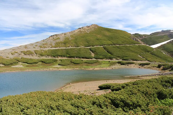
Mount Fujimi is a 2,817 m peak of Mount Norikura in Takayama, Gifu, near the boundary with Matsumoto, Nagano, within Chubu-Sangaku National Park. It lies on an easy hiking route linking Tatamidaira car park and Mount Daikoku. Its name refers to views of Mount Fuji to the southeast. Komakusa and other alpine plants bloom in summer. The summit is about 25 minutes from Tatamidaira and overlooks the Hotaka range, Tsurugaike and the alpine flower fields.
Mount Fujimi at a glance
- Weather: The most settled day in the next 7 days is Wed, November 4: clear, gusts up to 9 m/s. Sat, Nov 7: strong wind (gusts up to 19 m/s).
- Route: The shortest is Mount Norikura Kengamine Out-and-Back from Tatamidaira: about 2 h 48 min, 5.7 km, about 390 m of climbing.
Mount Fujimi weather (hourly, 14 days)
Sunrise today 06:14, sunset 16:53
| Tue, 11/3 | Wed, 11/4 | Thu, 11/5 | Fri, 11/6 | Sat, 11/7 | Sun, 11/8 | Mon, 11/9 | Tue, 11/10 | Wed, 11/11 | Thu, 11/12 | Fri, 11/13 | Sat, 11/14 | Sun, 11/15 | Mon, 11/16 | Tue, 11/17 | |||||||||||||||||||||||||||||||||||||||||||||||||||||||||||||||||||||||
|---|---|---|---|---|---|---|---|---|---|---|---|---|---|---|---|---|---|---|---|---|---|---|---|---|---|---|---|---|---|---|---|---|---|---|---|---|---|---|---|---|---|---|---|---|---|---|---|---|---|---|---|---|---|---|---|---|---|---|---|---|---|---|---|---|---|---|---|---|---|---|---|---|---|---|---|---|---|---|---|---|---|---|---|---|---|
| Japan time | 15 | 17 | 19 | 21 | 23 | 1 | 3 | 5 | 7 | 9 | 11 | 13 | 15 | 18 | 21 | 0 | 3 | 6 | 9 | 12 | 15 | 18 | 21 | 0 | 3 | 6 | 9 | 12 | 15 | 18 | 21 | 0 | 3 | 6 | 9 | 12 | 15 | 18 | 21 | 0 | 3 | 6 | 9 | 12 | 15 | 18 | 21 | 0 | 3 | 6 | 9 | 15 | 21 | 3 | 9 | 15 | 21 | 3 | 9 | 15 | 21 | 3 | 9 | 15 | 21 | 3 | 9 | 15 | 21 | 3 | 9 | 15 | 21 | 3 | 9 | 15 | 21 | 3 | 9 | 15 | 21 | 3 | 9 | 15 | |
  |   |  | | | | | | | |  | |   |   |   |   | | |   |   | | | | | | | | | | | | |   | |   | |   | | | | |  | | | | | | |   | | | | | | | |   | | |   | |  | | | | |   | | | | | | | | | | | | | | | | | | ||
| Temperature | °C | 2° | -3° | -6° | -6° | -7° | -6° | -5° | -6° | -5° | 3° | 6° | 7° | 6° | 2° | 1° | 1° | 1° | 1° | 4° | 7° | 7° | 3° | 3° | 2° | 2° | 2° | 3° | 4° | 3° | -1° | -3° | -4° | -6° | -6° | -5° | -4° | -5° | -8° | -8° | -9° | -11° | -10° | -1° | 1° | -1° | -5° | -5° | -4° | -4° | -3° | -1° | 0° | -7° | -8° | -1° | 0° | -4° | -10° | -8° | -5° | -11° | -9° | -2° | -1° | -9° | -6° | -5° | -3° | -11° | -7° | 0° | 1° | -6° | -4° | 1° | 1° | 0° | 0° | 2° | 0° | -6° | -7° | -2° | 0° |
| Precipitation | mm | 2.8 | 10 | 7 | 3.9 | 0.4 | 0.3 | 3.1 | 2.3 | 0.3 | 0.5 | 0.1 | 0.1 | 0.3 | 0.5 | 0.5 | 0.2 | 0.2 | 1.8 | 3.5 | 1.4 | 0.1 | 1.0 | 0.3 | 9 | 8 | 3.2 | 1.5 | 0.3 | ||||||||||||||||||||||||||||||||||||||||||||||||||||||||
| New snow | cm | 0.1 | 0.3 | 0.5 | 0.5 | 0.1 | <.1 | <.1 | 1.1 | 3.0 | 1.4 | 0.1 | 0.5 | <.1 | |||||||||||||||||||||||||||||||||||||||||||||||||||||||||||||||||||||||
| Snow depth | cm | 0 | 0 | 0 | 0 | 0 | 0 | 0 | 0 | 0 | 0 | 0 | 0 | 0 | 0 | 0 | 0 | 0 | 0 | 0 | 0 | 0 | 0 | 0 | 0 | 0 | 0 | 0 | 0 | 0 | 0 | 0 | 0 | 0 | 0 | <1 | <1 | <1 | <1 | <1 | <1 | <1 | <1 | <1 | <1 | <1 | <1 | <1 | <1 | <1 | <1 | <1 | <1 | 0 | 0 | 0 | 0 | <1 | 3 | 4 | 3 | 3 | 3 | 3 | 3 | 3 | 3 | 3 | 3 | 3 | 3 | 3 | 2 | 2 | 2 | 2 | 1 | <1 | <1 | <1 | 0 | 0 | 0 | 0 | 0 |
| Wind | m/s | 3 | 0 | 0 | 1 | 1 | 1 | 1 | 1 | 1 | 1 | 1 | 2 | 2 | 1 | 2 | 1 | 2 | 0 | 1 | 1 | 2 | 0 | 0 | 0 | 1 | 2 | 4 | 4 | 4 | 3 | 4 | 4 | 4 | 5 | 5 | 5 | 4 | 3 | 2 | 1 | 1 | 1 | 1 | 3 | 1 | 1 | 0 | 0 | 1 | 1 | 2 | 2 | 1 | 1 | 2 | 4 | 2 | 4 | 4 | 2 | 0 | 0 | 1 | 2 | 0 | 1 | 3 | 2 | 0 | 0 | 1 | 2 | 0 | 0 | 0 | 0 | 0 | 0 | 2 | 4 | 1 | 1 | 1 | 1 |
| Wind gusts | m/s | 10 | 9 | 5 | 4 | 4 | 4 | 4 | 3 | 3 | 5 | 7 | 9 | 9 | 7 | 8 | 8 | 11 | 10 | 9 | 8 | 9 | 9 | 6 | 7 | 9 | 9 | 13 | 14 | 14 | 13 | 13 | 14 | 16 | 18 | 19 | 19 | 19 | 16 | 12 | 11 | 9 | 9 | 8 | 10 | 10 | 6 | 5 | 7 | 9 | 9 | 8 | 12 | 8 | 5 | 7 | 16 | 14 | 21 | 21 | 17 | 11 | 4 | 6 | 9 | 9 | 10 | 11 | 12 | 11 | 6 | 5 | 8 | 6 | 6 | 7 | 12 | 13 | 14 | 12 | 16 | 15 | 7 | 5 | 8 |
| Wind dir. | ↓ | ↓ | ↓ | ↓ | ↓ | ↓ | ↓ | ↓ | ↓ | ↓ | ↓ | ↓ | ↓ | ↓ | ↓ | ↓ | ↓ | ↓ | ↓ | ↓ | ↓ | ↓ | ↓ | ↓ | ↓ | ↓ | ↓ | ↓ | ↓ | ↓ | ↓ | ↓ | ↓ | ↓ | ↓ | ↓ | ↓ | ↓ | ↓ | ↓ | ↓ | ↓ | ↓ | ↓ | ↓ | ↓ | ↓ | ↓ | ↓ | ↓ | ↓ | ↓ | ↓ | ↓ | ↓ | ↓ | ↓ | ↓ | ↓ | ↓ | ↓ | ↓ | ↓ | ↓ | ↓ | ↓ | ↓ | ↓ | ↓ | ↓ | ↓ | ↓ | ↓ | ↓ | ↓ | ↓ | ↓ | ↓ | ↓ | ↓ | ↓ | ↓ | ↓ | ↓ | |
Mount Fujimi live cameras
Mount Fujimi hiking routes
Hiking times are estimates calculated from the terrain.
Huts, campsites and lodging near Mount Fujimi
Mountain huts
- Katanokoya 2026: open July 5–October 5 · reservation required
- Kuraigaharasanso 2025: open February 7–October 25 · reservation required · sleeps 30
- 冷泉小屋 2026: open June 5–October 25 · reservation required · sleeps 11
- 頂上小屋 2026: open June 30–October 31
- 奥千町避難小屋
Lodging
- 乗鞍 白雲荘
- 乗鞍山の宿 銀嶺荘
Mount Fujimi facts
- Elevation
- 2,817 m
- Location
- Takayama, Gifu
36.121467, 137.556912 - National Park
- 中部山岳国立公園
- Volcano
- Active volcano (乗鞍岳)
- Website
- hidasanmyaku-gifu.jp
- Trail Map
- www.hidatakayama.or.jp (PDF)
- Access Information
- www.hidatakayama.or.jp
- Wikipedia
- ja.wikipedia.org