
Mount Kasumizawa
霞沢岳
Matsumoto, Nagano · Elevation 2,646 m
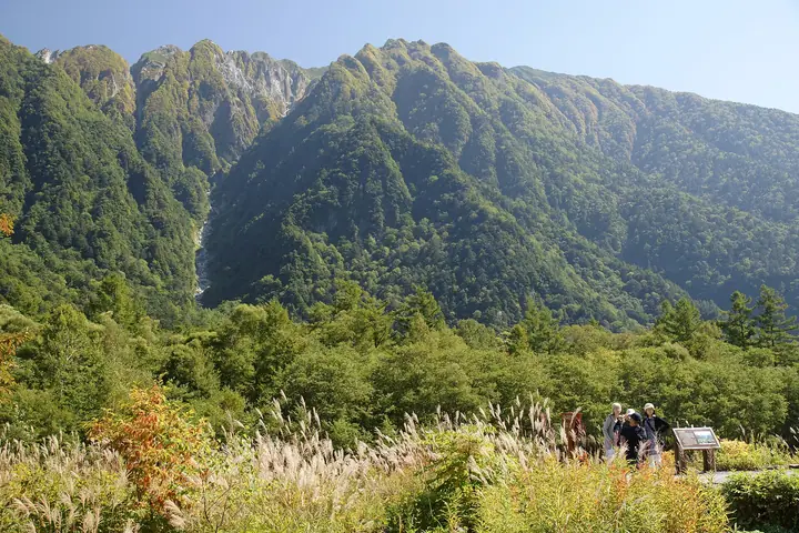
Mount Kasumizawa is a 2,646 m peak in Matsumoto City, Nagano Prefecture, marking the southern end of the Jōnen Range in the Hida (Northern Japanese) Alps. Set within Chūbu Sangaku National Park south of Kamikōchi, it is celebrated as one of the finest viewpoints in the area, with sweeping vistas over the Hotaka Range, Mount Yake, Mount Kasa, and Norikura, and is listed in the Nihon Nihyaku Meizan and the Shinshū Hyakumeizan. The classic Edo-era trail from Shimashima over Tokugō Pass to Kamikōchi passes its base, and the standard ascent traces the ridge from Kamikōchi via Myōjin and Tokugō Pass over Junction Peak, K1, and K2 to the summit — about six hours one-way, with K1 itself offering the most dramatic head-on view of the Hotaka skyline. A normal itinerary uses Tokugō-tōge-goya as a base and makes an out-and-back ascent from Tokugō Pass over two or more days.
Mount Kasumizawa at a glance
- Weather: The most settled day in the next 7 days is Wed, November 4: clear, gusts up to 8 m/s. Fri, Nov 6, Sat, Nov 7: strong wind (gusts up to 21 m/s).
Mount Kasumizawa weather (hourly, 14 days)
Sunrise today 06:13, sunset 16:53
| Tue, 11/3 | Wed, 11/4 | Thu, 11/5 | Fri, 11/6 | Sat, 11/7 | Sun, 11/8 | Mon, 11/9 | Tue, 11/10 | Wed, 11/11 | Thu, 11/12 | Fri, 11/13 | Sat, 11/14 | Sun, 11/15 | Mon, 11/16 | Tue, 11/17 | |||||||||||||||||||||||||||||||||||||||||||||||||||||||||||||||||||||||
|---|---|---|---|---|---|---|---|---|---|---|---|---|---|---|---|---|---|---|---|---|---|---|---|---|---|---|---|---|---|---|---|---|---|---|---|---|---|---|---|---|---|---|---|---|---|---|---|---|---|---|---|---|---|---|---|---|---|---|---|---|---|---|---|---|---|---|---|---|---|---|---|---|---|---|---|---|---|---|---|---|---|---|---|---|---|
| Japan time | 15 | 17 | 19 | 21 | 23 | 1 | 3 | 5 | 7 | 9 | 11 | 13 | 15 | 18 | 21 | 0 | 3 | 6 | 9 | 12 | 15 | 18 | 21 | 0 | 3 | 6 | 9 | 12 | 15 | 18 | 21 | 0 | 3 | 6 | 9 | 12 | 15 | 18 | 21 | 0 | 3 | 6 | 9 | 12 | 15 | 18 | 21 | 0 | 3 | 6 | 9 | 15 | 21 | 3 | 9 | 15 | 21 | 3 | 9 | 15 | 21 | 3 | 9 | 15 | 21 | 3 | 9 | 15 | 21 | 3 | 9 | 15 | 21 | 3 | 9 | 15 | 21 | 3 | 9 | 15 | 21 | 3 | 9 | 15 | |
  |   |   | | | | | | | |  | |   |   | |   | | |   | | | | | | | |   | | | | |   | | |   | | | | | |  | | | | | | | | | |   | | | | | | | | |   | |  | | | | |   | | | | | | | | | | | | | |   | | | | ||
| Temperature | °C | 1° | -3° | -6° | -7° | -7° | -6° | -5° | -5° | -3° | 2° | 5° | 6° | 5° | 1° | 0° | 1° | 0° | 1° | 3° | 6° | 7° | 2° | 2° | 1° | 1° | 1° | 2° | 4° | 2° | -2° | -5° | -6° | -7° | -8° | -7° | -7° | -8° | -10° | -10° | -10° | -11° | -11° | -2° | 1° | -1° | -6° | -5° | -5° | -5° | -5° | -3° | -1° | -9° | -10° | -2° | -2° | -5° | -11° | -8° | -5° | -11° | -10° | -2° | -2° | -10° | -6° | -4° | -2° | -9° | -7° | 0° | 1° | -7° | -5° | 1° | 0° | 0° | 0° | 2° | 0° | -6° | -6° | -2° | 0° |
| Precipitation | mm | 3.2 | 10 | 9 | 5 | 0.5 | 0.2 | 1.9 | 2.7 | 0.6 | 0.7 | 0.2 | 0.2 | 0.2 | 0.6 | 0.8 | 0.7 | 0.5 | 0.1 | 0.3 | 0.3 | 0.3 | 3.2 | 5 | 2.0 | 0.2 | 1.0 | 0.7 | 8 | 9 | 2.8 | 0.7 | 0.2 | ||||||||||||||||||||||||||||||||||||||||||||||||||||
| New snow | cm | <.1 | 0.2 | 0.6 | 0.8 | 0.7 | 0.5 | 0.1 | <.1 | <.1 | <.1 | 0.2 | 0.3 | <.1 | 0.2 | <.1 | 3.0 | 4.7 | 2.0 | <.1 | 0.1 | 0.7 | <.1 | <.1 | 0.1 | ||||||||||||||||||||||||||||||||||||||||||||||||||||||||||||
| Snow depth | cm | 0 | 0 | 0 | 0 | 0 | 0 | 0 | 0 | 0 | 0 | 0 | 0 | 0 | 0 | 0 | 0 | 0 | 0 | 0 | 0 | 0 | 0 | 0 | 0 | 0 | 0 | 0 | 0 | 0 | 0 | 0 | <1 | <1 | 1 | 2 | 2 | 2 | 2 | 2 | 2 | 2 | 2 | 1 | 1 | 1 | 1 | 1 | 1 | 2 | 2 | 2 | 2 | 2 | 2 | 2 | 1 | 4 | 7 | 8 | 8 | 8 | 7 | 7 | 7 | 6 | 7 | 7 | 6 | 6 | 6 | 6 | 5 | 5 | 5 | 5 | 4 | 3 | 2 | <1 | <1 | <1 | <1 | <1 | <1 |
| Wind | m/s | 2 | 1 | 1 | 1 | 1 | 1 | 1 | 0 | 0 | 1 | 1 | 2 | 2 | 1 | 1 | 1 | 1 | 1 | 2 | 2 | 3 | 1 | 2 | 2 | 2 | 3 | 4 | 5 | 5 | 3 | 4 | 4 | 5 | 5 | 5 | 6 | 4 | 3 | 2 | 2 | 2 | 1 | 1 | 2 | 1 | 1 | 1 | 2 | 3 | 2 | 2 | 2 | 1 | 1 | 2 | 5 | 3 | 7 | 3 | 1 | 1 | 1 | 1 | 2 | 1 | 3 | 2 | 1 | 0 | 1 | 1 | 1 | 1 | 2 | 1 | 2 | 3 | 3 | 3 | 3 | 1 | 1 | 1 | 1 |
| Wind gusts | m/s | 9 | 9 | 6 | 6 | 6 | 6 | 5 | 5 | 4 | 5 | 7 | 8 | 8 | 8 | 6 | 6 | 6 | 6 | 10 | 10 | 12 | 12 | 8 | 10 | 11 | 11 | 14 | 18 | 18 | 17 | 15 | 17 | 18 | 19 | 19 | 21 | 20 | 16 | 13 | 12 | 11 | 11 | 9 | 9 | 9 | 7 | 7 | 9 | 12 | 12 | 10 | 13 | 8 | 5 | 7 | 17 | 15 | 24 | 26 | 15 | 7 | 5 | 7 | 11 | 9 | 13 | 12 | 10 | 7 | 5 | 5 | 7 | 6 | 9 | 9 | 14 | 14 | 17 | 14 | 17 | 13 | 6 | 5 | 7 |
| Wind dir. | ↓ | ↓ | ↓ | ↓ | ↓ | ↓ | ↓ | ↓ | ↓ | ↓ | ↓ | ↓ | ↓ | ↓ | ↓ | ↓ | ↓ | ↓ | ↓ | ↓ | ↓ | ↓ | ↓ | ↓ | ↓ | ↓ | ↓ | ↓ | ↓ | ↓ | ↓ | ↓ | ↓ | ↓ | ↓ | ↓ | ↓ | ↓ | ↓ | ↓ | ↓ | ↓ | ↓ | ↓ | ↓ | ↓ | ↓ | ↓ | ↓ | ↓ | ↓ | ↓ | ↓ | ↓ | ↓ | ↓ | ↓ | ↓ | ↓ | ↓ | ↓ | ↓ | ↓ | ↓ | ↓ | ↓ | ↓ | ↓ | ↓ | ↓ | ↓ | ↓ | ↓ | ↓ | ↓ | ↓ | ↓ | ↓ | ↓ | ↓ | ↓ | ↓ | ↓ | ↓ | |
Huts, campsites and lodging near Mount Kasumizawa
Mountain huts
- Tokugoto Toge Hut 2026: open July 18–October 13 · reservation required · sleeps 14
- Kamonjigoya 2026: open April 25–November 4 · reservation required
- Yamanohidaya
- 焼岳小屋 2026: open June 15–October 15 · reservation required
Campsites
- Konashidaira Camping Retreat
Lodging
- Taisyoike Hotel
- Kamikochi Imperial Hotel
- Kamikochi Nishi-ito-ya Mountain Lodge
- 上高地公園活動ステーション
- Kamikochi Alpen Hotel
Lists that include Mount Kasumizawa
Japan 200 Famous Mountains · Japan's 300 Famous Mountains · Koshinetsu 100 Famous Mountains · Shinshu 100 Famous Mountains · Elevations of 1003 Mountains of Japan · 1000 Mountains of Japan
Mount Kasumizawa facts
- Elevation
- 2,646 m
- Location
- Matsumoto, Nagano
36.221227, 137.640592 - National Park
- 中部山岳国立公園
- Website
- tokugo.com
- Access Information
- tokugo.com
- Wikipedia
- ja.wikipedia.org