
Mount Kamuro
禿岳
Mogami, Yamagata / Ōsaki-shi, Miyagi · Elevation 1,262 m
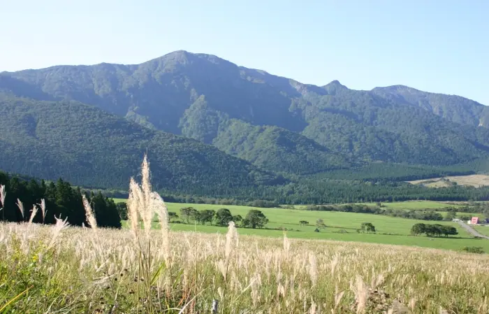
Mount Kamuro (1,262 m) straddles the border of Naruko-Onsen in Ōsaki, Miyagi and Mogami, Yamagata, and is the highest peak of the rim around the Onikōbe Caldera. Composed largely of granodiorite, its sharp form has earned it the nickname "Little Tanigawa-dake." The trailhead at Hanatate Pass on the prefectural road gives an accessible climb, and an annual yamabiraki ceremony is held on the last Sunday of May. The peak is included in the Tōhoku Hyakumeizan, the Yamagata Hyakumeizan, and the Onsen Hyakumeizan.
Mount Kamuro at a glance
- Weather: The most settled day in the next 7 days is Wed, November 4: cloudy, gusts up to 11 m/s. Fri, Nov 6, Sat, Nov 7, Sun, Nov 8: strong wind (gusts up to 23 m/s).
- Route: The shortest is Mount Kamuro Out-and-Back via Hanatate Pass: about 3 h 29 min, 5.5 km, about 500 m of climbing.
Mount Kamuro weather (hourly, 14 days)
Sunrise today 06:06, sunset 16:37
| Tue, 11/3 | Wed, 11/4 | Thu, 11/5 | Fri, 11/6 | Sat, 11/7 | Sun, 11/8 | Mon, 11/9 | Tue, 11/10 | Wed, 11/11 | Thu, 11/12 | Fri, 11/13 | Sat, 11/14 | Sun, 11/15 | Mon, 11/16 | Tue, 11/17 | |||||||||||||||||||||||||||||||||||||||||||||||||||||||||||||||||||||||
|---|---|---|---|---|---|---|---|---|---|---|---|---|---|---|---|---|---|---|---|---|---|---|---|---|---|---|---|---|---|---|---|---|---|---|---|---|---|---|---|---|---|---|---|---|---|---|---|---|---|---|---|---|---|---|---|---|---|---|---|---|---|---|---|---|---|---|---|---|---|---|---|---|---|---|---|---|---|---|---|---|---|---|---|---|---|
| Japan time | 15 | 17 | 19 | 21 | 23 | 1 | 3 | 5 | 7 | 9 | 11 | 13 | 15 | 18 | 21 | 0 | 3 | 6 | 9 | 12 | 15 | 18 | 21 | 0 | 3 | 6 | 9 | 12 | 15 | 18 | 21 | 0 | 3 | 6 | 9 | 12 | 15 | 18 | 21 | 0 | 3 | 6 | 9 | 12 | 15 | 18 | 21 | 0 | 3 | 6 | 9 | 15 | 21 | 3 | 9 | 15 | 21 | 3 | 9 | 15 | 21 | 3 | 9 | 15 | 21 | 3 | 9 | 15 | 21 | 3 | 9 | 15 | 21 | 3 | 9 | 15 | 21 | 3 | 9 | 15 | 21 | 3 | 9 | 15 | |
  |   | | |  | | |   |   | |   |   |   | | | |   | | | | |   | | | | | | | | | | |   | |   | |   |   | | | | |   | | | | | | |   | | | | |  | | | |   | |   | | | | | | | | | | | |  | | | | | | | |   | | | | ||
| Temperature | °C | 4° | 1° | 0° | 0° | -1° | 0° | 1° | 1° | 2° | 5° | 7° | 6° | 6° | 2° | 2° | 3° | 3° | 4° | 5° | 7° | 8° | 7° | 7° | 7° | 6° | 7° | 7° | 8° | 6° | 4° | 2° | -1° | -2° | -3° | -3° | -3° | -2° | -3° | -4° | -4° | -3° | -3° | -1° | 0° | -1° | -3° | -3° | -3° | -3° | -4° | 0° | -1° | -4° | -5° | -1° | 1° | -1° | -2° | -2° | 0° | -4° | -3° | 0° | 1° | -1° | -1° | -2° | -1° | -3° | -4° | 0° | 3° | -3° | -1° | 5° | 7° | 3° | 3° | 5° | 1° | -4° | -4° | -2° | 0° |
| Precipitation | mm | 0.4 | 0.4 | 0.2 | 3.2 | 5 | 3.9 | 1.5 | 0.1 | 1.7 | 0.6 | 1.2 | 3.5 | 4.4 | 0.8 | 1.7 | 1.1 | 2.2 | 2.2 | 2.5 | 1.8 | 2.4 | 1.3 | 0.7 | 1.3 | 1.3 | 0.8 | 0.7 | 0.3 | 0.2 | 0.3 | 6 | 2.7 | 0.6 | 0.5 | 0.3 | 7 | 1.5 | 0.1 | 1.5 | 6 | 1.6 | 3.1 | 2.7 | |||||||||||||||||||||||||||||||||||||||||
| New snow | cm | 0.2 | 1.4 | 1.5 | 2.1 | 1.1 | 0.7 | 1.3 | 1.2 | 0.7 | 0.5 | <.1 | 0.2 | <.1 | 0.3 | 1.5 | <.1 | <.1 | <.1 | <.1 | 0.1 | 0.1 | |||||||||||||||||||||||||||||||||||||||||||||||||||||||||||||||
| Snow depth | cm | 0 | 0 | 0 | 0 | 0 | 0 | 0 | 0 | 0 | 0 | 0 | 0 | 0 | 0 | 0 | 0 | 0 | 0 | 0 | 0 | 0 | 0 | 0 | 0 | 0 | 0 | 0 | 0 | 0 | 0 | 0 | 0 | <1 | 1 | 1 | 2 | 2 | 2 | 3 | 3 | 3 | 3 | 3 | 2 | 2 | 2 | 1 | 1 | 1 | 1 | 1 | 1 | <1 | <1 | <1 | <1 | <1 | <1 | <1 | <1 | <1 | <1 | 0 | 0 | 0 | 0 | <1 | 0 | 0 | 0 | 0 | 0 | 0 | 0 | 0 | 0 | 0 | 0 | 0 | 0 | <1 | <1 | <1 | 0 |
| Wind | m/s | 5 | 3 | 3 | 3 | 2 | 3 | 3 | 4 | 3 | 3 | 3 | 2 | 1 | 2 | 3 | 3 | 3 | 2 | 2 | 2 | 2 | 1 | 1 | 1 | 2 | 2 | 3 | 7 | 7 | 6 | 6 | 5 | 5 | 5 | 5 | 6 | 6 | 7 | 7 | 7 | 7 | 7 | 8 | 9 | 7 | 5 | 4 | 4 | 4 | 2 | 4 | 3 | 2 | 1 | 1 | 6 | 4 | 4 | 4 | 5 | 2 | 2 | 4 | 5 | 1 | 2 | 5 | 7 | 4 | 3 | 3 | 3 | 0 | 1 | 1 | 1 | 1 | 1 | 2 | 6 | 7 | 5 | 3 | 3 |
| Wind gusts | m/s | 15 | 13 | 9 | 9 | 8 | 9 | 10 | 10 | 10 | 10 | 11 | 10 | 7 | 5 | 7 | 9 | 9 | 8 | 6 | 5 | 7 | 6 | 4 | 5 | 7 | 7 | 11 | 22 | 21 | 18 | 15 | 16 | 15 | 16 | 17 | 22 | 21 | 22 | 20 | 20 | 19 | 20 | 21 | 23 | 23 | 19 | 14 | 11 | 10 | 10 | 10 | 11 | 8 | 6 | 5 | 15 | 17 | 12 | 12 | 15 | 14 | 7 | 10 | 13 | 12 | 7 | 13 | 17 | 17 | 11 | 9 | 11 | 7 | 4 | 5 | 6 | 6 | 6 | 6 | 16 | 20 | 19 | 12 | 10 |
| Wind dir. | ↓ | ↓ | ↓ | ↓ | ↓ | ↓ | ↓ | ↓ | ↓ | ↓ | ↓ | ↓ | ↓ | ↓ | ↓ | ↓ | ↓ | ↓ | ↓ | ↓ | ↓ | ↓ | ↓ | ↓ | ↓ | ↓ | ↓ | ↓ | ↓ | ↓ | ↓ | ↓ | ↓ | ↓ | ↓ | ↓ | ↓ | ↓ | ↓ | ↓ | ↓ | ↓ | ↓ | ↓ | ↓ | ↓ | ↓ | ↓ | ↓ | ↓ | ↓ | ↓ | ↓ | ↓ | ↓ | ↓ | ↓ | ↓ | ↓ | ↓ | ↓ | ↓ | ↓ | ↓ | ↓ | ↓ | ↓ | ↓ | ↓ | ↓ | ↓ | ↓ | ↓ | ↓ | ↓ | ↓ | ↓ | ↓ | ↓ | ↓ | ↓ | ↓ | ↓ | ↓ | |
Mount Kamuro hiking routes
Hiking times are estimates calculated from the terrain.
Huts, campsites and lodging near Mount Kamuro
Lodging
- リゾートパークホテルオニコウベ
Lists that include Mount Kamuro
100 Famous Hot Spring Mountains · Tohoku 100 Famous Mountains · Yamagata 100 Famous Mountains · Elevations of 1003 Mountains of Japan · 1000 Mountains of Japan
Mount Kamuro facts
- Also known as
- 小鏑山
- Elevation
- 1,262 m
- Location
- Mogami, Yamagata / Ōsaki-shi, Miyagi
38.810946, 140.595126 - Website
- yamagatayama.com
- Wikipedia
- ja.wikipedia.org