
Mt. Komatayama
小又山
Mogami, Yamagata · Elevation 1,367 m
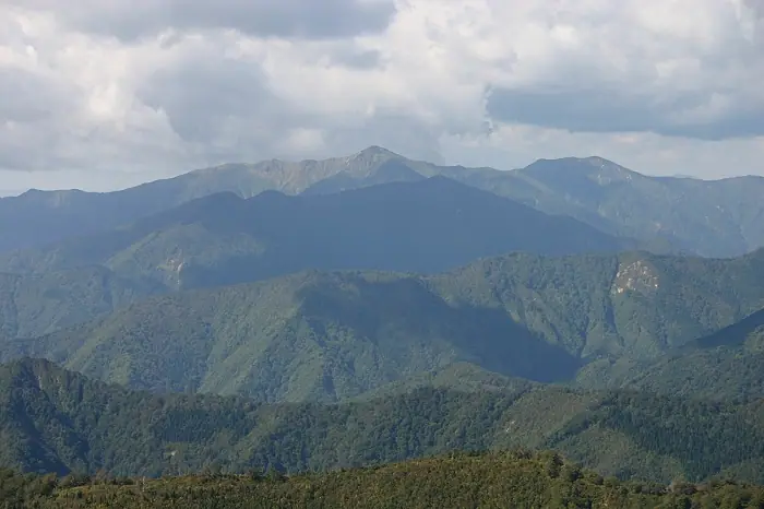
Mt. Komatayama is a 1,367 m peak on the border between Shinjō City and Mogami Town in Yamagata Prefecture, the highest summit of the Kamuro Range — a spur of the Ōu Mountains that extends more than 30 km and is nicknamed the 'Michinoku Mini-Alps'. The peak lies within Kurikoma Quasi-National Park, with a summit area covered in beech forest and osabagusa, sitting at the centre of the main ridge between Mt. Kamuro-san (via Tengumori) to the north and Mt. Hiuchidake / Mokuzōzan to the south. The Nishinomata-sawa and Komataguchi routes provide the standard ascents, best climbed from June through October.
Mt. Komatayama at a glance
- Weather: The most settled day in the next 7 days is Wed, November 4: cloudy, gusts up to 8 m/s. Fri, Nov 6, Sat, Nov 7, Sun, Nov 8: strong wind (gusts up to 23 m/s).
Mt. Komatayama weather (hourly, 14 days)
Sunrise today 06:06, sunset 16:37
| Tue, 11/3 | Wed, 11/4 | Thu, 11/5 | Fri, 11/6 | Sat, 11/7 | Sun, 11/8 | Mon, 11/9 | Tue, 11/10 | Wed, 11/11 | Thu, 11/12 | Fri, 11/13 | Sat, 11/14 | Sun, 11/15 | Mon, 11/16 | Tue, 11/17 | |||||||||||||||||||||||||||||||||||||||||||||||||||||||||||||||||||||||
|---|---|---|---|---|---|---|---|---|---|---|---|---|---|---|---|---|---|---|---|---|---|---|---|---|---|---|---|---|---|---|---|---|---|---|---|---|---|---|---|---|---|---|---|---|---|---|---|---|---|---|---|---|---|---|---|---|---|---|---|---|---|---|---|---|---|---|---|---|---|---|---|---|---|---|---|---|---|---|---|---|---|---|---|---|---|
| Japan time | 15 | 17 | 19 | 21 | 23 | 1 | 3 | 5 | 7 | 9 | 11 | 13 | 15 | 18 | 21 | 0 | 3 | 6 | 9 | 12 | 15 | 18 | 21 | 0 | 3 | 6 | 9 | 12 | 15 | 18 | 21 | 0 | 3 | 6 | 9 | 12 | 15 | 18 | 21 | 0 | 3 | 6 | 9 | 12 | 15 | 18 | 21 | 0 | 3 | 6 | 9 | 15 | 21 | 3 | 9 | 15 | 21 | 3 | 9 | 15 | 21 | 3 | 9 | 15 | 21 | 3 | 9 | 15 | 21 | 3 | 9 | 15 | 21 | 3 | 9 | 15 | 21 | 3 | 9 | 15 | 21 | 3 | 9 | 15 | |
 |   | | |  | | |   |   |   |   | | | | | |   | |   | | |   | | | | | | | | | | |   | |   | |   |   | | | | |   | |   | | | | |   | | |   | | | | | | | | | | | | | | | | | | | |  | | | | | | | |   |   | | | ||
| Temperature | °C | 4° | 2° | 0° | 0° | 0° | 0° | 0° | 1° | 1° | 4° | 7° | 7° | 7° | 2° | 3° | 4° | 4° | 5° | 6° | 7° | 8° | 7° | 7° | 7° | 6° | 6° | 8° | 9° | 7° | 4° | 2° | 0° | -1° | -2° | -2° | -2° | -1° | -2° | -3° | -3° | -3° | -2° | 0° | 1° | 0° | -1° | -3° | -2° | -2° | -3° | 1° | 0° | -4° | -5° | 0° | 2° | 0° | -2° | -2° | 1° | -4° | -2° | 1° | 2° | -1° | 0° | -1° | 0° | -2° | -4° | 0° | 3° | -3° | -1° | 4° | 8° | 3° | 3° | 4° | 2° | -3° | -3° | -1° | 1° |
| Precipitation | mm | 0.2 | 0.2 | 0.2 | 0.4 | 2.9 | 4.8 | 2.9 | 1.1 | 0.1 | 1.8 | 0.7 | 1.7 | 4.4 | 4.1 | 0.8 | 1.9 | 1.1 | 2.1 | 2.2 | 2.8 | 2.3 | 2.7 | 1.7 | 0.7 | 1.4 | 1.8 | 1.5 | 1.3 | 0.3 | 0.2 | 0.9 | 6 | 2.7 | 0.5 | 0.3 | 0.2 | 8 | 1.3 | 1.7 | 5 | 1.5 | 2.1 | 2.4 | |||||||||||||||||||||||||||||||||||||||||
| New snow | cm | <.1 | 0.4 | 0.7 | 1.4 | 0.9 | 0.3 | 0.6 | 0.6 | 0.3 | 0.2 | <.1 | 0.1 | 0.6 | <.1 | <.1 | |||||||||||||||||||||||||||||||||||||||||||||||||||||||||||||||||||||
| Snow depth | cm | 0 | 0 | 0 | 0 | 0 | 0 | 0 | 0 | 0 | 0 | 0 | 0 | 0 | 0 | 0 | 0 | 0 | 0 | 0 | 0 | 0 | 0 | 0 | 0 | 0 | 0 | 0 | 0 | 0 | 0 | 0 | 0 | 0 | <1 | <1 | 1 | 1 | <1 | 1 | 1 | 1 | 1 | 1 | <1 | <1 | <1 | <1 | <1 | <1 | <1 | <1 | <1 | 0 | 0 | 0 | 0 | 0 | 0 | <1 | 0 | 0 | 0 | 0 | 0 | 0 | 0 | 0 | 0 | 0 | 0 | 0 | 0 | 0 | 0 | 0 | 0 | 0 | 0 | 0 | 0 | 0 | 0 | 0 | 0 |
| Wind | m/s | 5 | 3 | 2 | 2 | 1 | 1 | 1 | 1 | 1 | 2 | 3 | 2 | 1 | 2 | 3 | 4 | 4 | 3 | 2 | 2 | 1 | 1 | 1 | 1 | 1 | 1 | 3 | 7 | 6 | 5 | 5 | 4 | 4 | 3 | 5 | 5 | 7 | 6 | 5 | 5 | 6 | 6 | 7 | 9 | 7 | 4 | 3 | 3 | 2 | 2 | 3 | 3 | 1 | 1 | 1 | 6 | 5 | 5 | 3 | 5 | 2 | 1 | 2 | 4 | 1 | 2 | 5 | 6 | 3 | 2 | 2 | 3 | 0 | 0 | 1 | 1 | 2 | 1 | 1 | 5 | 5 | 3 | 2 | 2 |
| Wind gusts | m/s | 14 | 13 | 9 | 7 | 6 | 6 | 6 | 7 | 6 | 7 | 8 | 8 | 7 | 5 | 8 | 11 | 11 | 10 | 8 | 5 | 6 | 4 | 4 | 6 | 5 | 5 | 9 | 21 | 21 | 18 | 14 | 14 | 13 | 16 | 16 | 21 | 22 | 22 | 19 | 19 | 17 | 17 | 19 | 23 | 23 | 18 | 11 | 8 | 8 | 8 | 8 | 10 | 8 | 5 | 5 | 15 | 18 | 14 | 12 | 15 | 14 | 6 | 6 | 13 | 11 | 6 | 13 | 15 | 15 | 9 | 7 | 10 | 7 | 3 | 4 | 7 | 6 | 6 | 4 | 14 | 16 | 15 | 9 | 9 |
| Wind dir. | ↓ | ↓ | ↓ | ↓ | ↓ | ↓ | ↓ | ↓ | ↓ | ↓ | ↓ | ↓ | ↓ | ↓ | ↓ | ↓ | ↓ | ↓ | ↓ | ↓ | ↓ | ↓ | ↓ | ↓ | ↓ | ↓ | ↓ | ↓ | ↓ | ↓ | ↓ | ↓ | ↓ | ↓ | ↓ | ↓ | ↓ | ↓ | ↓ | ↓ | ↓ | ↓ | ↓ | ↓ | ↓ | ↓ | ↓ | ↓ | ↓ | ↓ | ↓ | ↓ | ↓ | ↓ | ↓ | ↓ | ↓ | ↓ | ↓ | ↓ | ↓ | ↓ | ↓ | ↓ | ↓ | ↓ | ↓ | ↓ | ↓ | ↓ | ↓ | ↓ | ↓ | ↓ | ↓ | ↓ | ↓ | ↓ | ↓ | ↓ | ↓ | ↓ | ↓ | ↓ | |
Huts, campsites and lodging near Mt. Komatayama
Mountain huts
Lists that include Mt. Komatayama
Tohoku 100 Famous Mountains · Yamagata 100 Famous Mountains · 1000 Mountains of Japan
Mt. Komatayama facts
- Elevation
- 1,367 m
- Location
- Mogami, Yamagata
38.862894, 140.485686 - National Park
- 栗駒国定公園
- Website
- yamagatayama.com