
Mae-Kesamaru
前袈裟丸山
Midori, Gunma / Nikkō-shi, Tochigi · Elevation 1,878 m
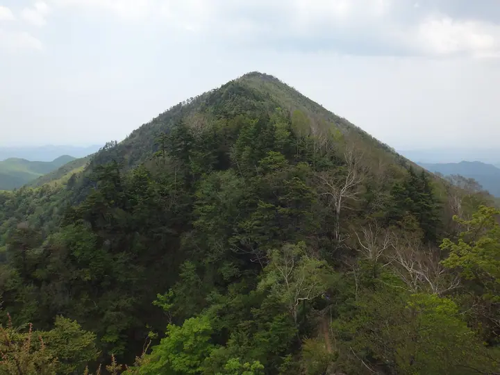
Mae-Kesamaru is the 1,878-meter southern summit of the five-peak Kesamaru massif, straddling Tochigi's Nikkō and Gunma's Numata and Midori in the southern Ashio mountains. The mountain is a remnant of the ancient Kōkai volcano, and the Tōnosawa trail up its flank passes the carved 'Reclining Buddha' (Neshaka-zō). It carries a first-order triangulation marker and is listed in such selections as Japan's 300 Famous Mountains, the Kantō Hyakuzan, and the Ittō-Sankakuten Hyakumeizan, and is celebrated for its Akayashio azalea blooms in late spring.
Mae-Kesamaru at a glance
- Weather: The most settled day in the next 7 days is Wed, November 4: clear, gusts up to 8 m/s. Sat, Nov 7: strong wind (gusts up to 23 m/s).
- Route: The shortest is Mount Mae-Kesamaru Return from Oriba Trailhead: about 6 h 41 min, 10.6 km, about 980 m of climbing.
Mae-Kesamaru weather (hourly, 14 days)
Sunrise today 06:07, sunset 16:45
| Tue, 11/3 | Wed, 11/4 | Thu, 11/5 | Fri, 11/6 | Sat, 11/7 | Sun, 11/8 | Mon, 11/9 | Tue, 11/10 | Wed, 11/11 | Thu, 11/12 | Fri, 11/13 | Sat, 11/14 | Sun, 11/15 | Mon, 11/16 | Tue, 11/17 | |||||||||||||||||||||||||||||||||||||||||||||||||||||||||||||||||||||||
|---|---|---|---|---|---|---|---|---|---|---|---|---|---|---|---|---|---|---|---|---|---|---|---|---|---|---|---|---|---|---|---|---|---|---|---|---|---|---|---|---|---|---|---|---|---|---|---|---|---|---|---|---|---|---|---|---|---|---|---|---|---|---|---|---|---|---|---|---|---|---|---|---|---|---|---|---|---|---|---|---|---|---|---|---|---|
| Japan time | 15 | 17 | 19 | 21 | 23 | 1 | 3 | 5 | 7 | 9 | 11 | 13 | 15 | 18 | 21 | 0 | 3 | 6 | 9 | 12 | 15 | 18 | 21 | 0 | 3 | 6 | 9 | 12 | 15 | 18 | 21 | 0 | 3 | 6 | 9 | 12 | 15 | 18 | 21 | 0 | 3 | 6 | 9 | 12 | 15 | 18 | 21 | 0 | 3 | 6 | 9 | 15 | 21 | 3 | 9 | 15 | 21 | 3 | 9 | 15 | 21 | 3 | 9 | 15 | 21 | 3 | 9 | 15 | 21 | 3 | 9 | 15 | 21 | 3 | 9 | 15 | 21 | 3 | 9 | 15 | 21 | 3 | 9 | 15 | |
 |   | | |   | | | | |   | | |   |   |   | | | |   |   |   | | |  | | | | | | | | | | | | | | | | | | | | | | | | | | | | | | | | | | |   |   |   | | | |  | | | | | | | | | | | | |   | | | | | | | ||
| Temperature | °C | 6° | 2° | 0° | 0° | 0° | -2° | -1° | -2° | 0° | 5° | 7° | 8° | 5° | 2° | 2° | 3° | 4° | 5° | 7° | 11° | 9° | 6° | 4° | 4° | 5° | 4° | 10° | 12° | 10° | 5° | 3° | 2° | 0° | -1° | 0° | 1° | -1° | -3° | -3° | -4° | -4° | -4° | 1° | 5° | 3° | -2° | -3° | -2° | -1° | -1° | 2° | 4° | 0° | -1° | 1° | 2° | -1° | -2° | -1° | -1° | -2° | -4° | 1° | 4° | -1° | -2° | 2° | 0° | -4° | -5° | 2° | 3° | -3° | -2° | 6° | 7° | 4° | 5° | 11° | 6° | -1° | -4° | 1° | 2° |
| Precipitation | mm | 0.5 | 1.2 | 8 | 9 | 1.6 | 0.1 | 0.1 | 0.1 | 0.6 | 0.2 | 0.2 | 1.2 | 1.7 | 0.1 | 0.2 | 4.1 | 8 | 0.3 | ||||||||||||||||||||||||||||||||||||||||||||||||||||||||||||||||||
| New snow | cm | 1.0 | 1.3 | <.1 | |||||||||||||||||||||||||||||||||||||||||||||||||||||||||||||||||||||||||||||||||
| Snow depth | cm | 0 | 0 | 0 | 0 | 0 | 0 | 0 | 0 | 0 | 0 | 0 | 0 | 0 | 0 | 0 | 0 | 0 | 0 | 0 | 0 | 0 | 0 | 0 | 0 | 0 | 0 | 0 | 0 | 0 | 0 | 0 | 0 | 0 | 0 | 0 | 0 | 0 | 0 | 0 | 0 | 0 | 0 | 0 | 0 | 0 | 0 | 0 | 0 | 0 | 0 | 0 | 0 | 0 | 0 | 0 | 0 | 0 | 0 | <1 | <1 | <1 | <1 | <1 | 0 | 0 | 0 | 0 | 0 | 0 | 0 | 0 | 0 | 0 | 0 | 0 | 0 | 0 | 0 | 0 | 0 | 0 | 0 | 0 | 0 |
| Wind | m/s | 2 | 1 | 0 | 0 | 1 | 1 | 1 | 1 | 0 | 1 | 1 | 2 | 2 | 1 | 1 | 1 | 1 | 2 | 2 | 0 | 1 | 0 | 1 | 1 | 1 | 1 | 3 | 3 | 2 | 2 | 2 | 4 | 5 | 5 | 6 | 7 | 7 | 5 | 5 | 4 | 4 | 3 | 3 | 3 | 1 | 0 | 1 | 0 | 1 | 1 | 1 | 1 | 0 | 0 | 1 | 2 | 0 | 3 | 7 | 7 | 2 | 2 | 1 | 2 | 1 | 1 | 3 | 5 | 2 | 3 | 1 | 1 | 1 | 1 | 1 | 1 | 1 | 1 | 1 | 6 | 5 | 2 | 1 | 1 |
| Wind gusts | m/s | 9 | 7 | 4 | 4 | 4 | 4 | 4 | 4 | 4 | 4 | 6 | 8 | 8 | 6 | 5 | 6 | 6 | 9 | 8 | 5 | 5 | 5 | 4 | 5 | 5 | 5 | 11 | 11 | 11 | 8 | 9 | 14 | 16 | 18 | 19 | 23 | 22 | 21 | 17 | 16 | 15 | 14 | 12 | 11 | 10 | 6 | 6 | 6 | 6 | 6 | 6 | 7 | 5 | 3 | 4 | 7 | 8 | 9 | 25 | 26 | 23 | 9 | 7 | 9 | 7 | 6 | 11 | 17 | 15 | 9 | 8 | 6 | 6 | 4 | 5 | 8 | 6 | 8 | 8 | 21 | 20 | 18 | 7 | 7 |
| Wind dir. | ↓ | ↓ | ↓ | ↓ | ↓ | ↓ | ↓ | ↓ | ↓ | ↓ | ↓ | ↓ | ↓ | ↓ | ↓ | ↓ | ↓ | ↓ | ↓ | ↓ | ↓ | ↓ | ↓ | ↓ | ↓ | ↓ | ↓ | ↓ | ↓ | ↓ | ↓ | ↓ | ↓ | ↓ | ↓ | ↓ | ↓ | ↓ | ↓ | ↓ | ↓ | ↓ | ↓ | ↓ | ↓ | ↓ | ↓ | ↓ | ↓ | ↓ | ↓ | ↓ | ↓ | ↓ | ↓ | ↓ | ↓ | ↓ | ↓ | ↓ | ↓ | ↓ | ↓ | ↓ | ↓ | ↓ | ↓ | ↓ | ↓ | ↓ | ↓ | ↓ | ↓ | ↓ | ↓ | ↓ | ↓ | ↓ | ↓ | ↓ | ↓ | ↓ | ↓ | ↓ | |
Mae-Kesamaru hiking routes
Hiking times are estimates calculated from the terrain.
Huts, campsites and lodging near Mae-Kesamaru
Mountain huts
Lists that include Mae-Kesamaru
100 Famous Mountains with First-order Triangulation Points · Gunma 100 Famous Mountains · Tochigi 100 Famous Mountains
Mae-Kesamaru facts
- Also known as
- 袈裟丸山
- Elevation
- 1,878 m
- Location
- Midori, Gunma / Nikkō-shi, Tochigi
36.627669, 139.329386 - Website
- 16106midori.jp
- Trail Map
- 16106midori.jp (PDF)
- Wikipedia
- ja.wikipedia.org