
Mt. Waremeki
割引岳
Minamiuonuma, Niigata · Elevation 1,931 m
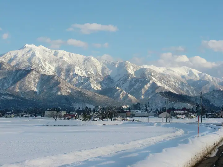
Waremekidake (also read Waribikidake) is a 1,930.9 m peak in Minami-Uonuma City, Niigata, the sharp northwestern shoulder of the Makihatayama massif (one of Fukada Kyūya's Hyakumeizan), forming a four-summit complex with the main peak, Onhataya and Ushigatake. A first-order triangulation point sits on the top, earning the peak inclusion in the Ittō Sankakuten Hyakumeizan list. Hikers reach it either by way of the standard Idoone ridge from Sakurazaka in Shimizu and a side-trip from Onhataya, or by the more demanding Nukubi-zawa route which climbs the gorge directly to the summit and is regarded as advanced terrain.
Mt. Waremeki at a glance
- Weather: The most settled day in the next 7 days is Wed, November 4: clear, gusts up to 8 m/s. Sat, Nov 7: strong wind (gusts up to 18 m/s).
Mt. Waremeki weather (hourly, 14 days)
Sunrise today 06:09, sunset 16:46
| Tue, 11/3 | Wed, 11/4 | Thu, 11/5 | Fri, 11/6 | Sat, 11/7 | Sun, 11/8 | Mon, 11/9 | Tue, 11/10 | Wed, 11/11 | Thu, 11/12 | Fri, 11/13 | Sat, 11/14 | Sun, 11/15 | Mon, 11/16 | Tue, 11/17 | |||||||||||||||||||||||||||||||||||||||||||||||||||||||||||||||||||||||
|---|---|---|---|---|---|---|---|---|---|---|---|---|---|---|---|---|---|---|---|---|---|---|---|---|---|---|---|---|---|---|---|---|---|---|---|---|---|---|---|---|---|---|---|---|---|---|---|---|---|---|---|---|---|---|---|---|---|---|---|---|---|---|---|---|---|---|---|---|---|---|---|---|---|---|---|---|---|---|---|---|---|---|---|---|---|
| Japan time | 15 | 17 | 19 | 21 | 23 | 1 | 3 | 5 | 7 | 9 | 11 | 13 | 15 | 18 | 21 | 0 | 3 | 6 | 9 | 12 | 15 | 18 | 21 | 0 | 3 | 6 | 9 | 12 | 15 | 18 | 21 | 0 | 3 | 6 | 9 | 12 | 15 | 18 | 21 | 0 | 3 | 6 | 9 | 12 | 15 | 18 | 21 | 0 | 3 | 6 | 9 | 15 | 21 | 3 | 9 | 15 | 21 | 3 | 9 | 15 | 21 | 3 | 9 | 15 | 21 | 3 | 9 | 15 | 21 | 3 | 9 | 15 | 21 | 3 | 9 | 15 | 21 | 3 | 9 | 15 | 21 | 3 | 9 | 15 | |
  |   | |   | | | | |  | | | |   |   | |   | | |   | | | | | | | | | | | | | | |   |   | | | | | |   | |   | | | | | | | | |   | |   |   | | | | | | | | | |   | | | | |   | | |  | | | | | | | | | | | | ||
| Temperature | °C | 1° | 0° | -2° | -4° | -5° | -4° | -4° | -3° | -2° | 4° | 6° | 8° | 7° | 2° | 2° | 2° | 2° | 2° | 4° | 9° | 9° | 5° | 5° | 4° | 4° | 4° | 5° | 5° | 6° | 3° | 1° | -1° | -2° | -3° | -4° | -4° | -4° | -4° | -4° | -5° | -5° | -5° | -3° | -2° | -2° | -4° | -5° | -5° | -5° | -5° | -1° | -1° | -3° | -4° | 1° | 1° | -1° | -5° | -4° | -4° | -4° | -4° | -2° | -2° | -6° | -2° | -4° | -3° | -5° | -6° | -1° | 2° | -7° | -6° | 4° | 4° | 0° | 2° | 3° | 1° | -4° | -6° | -4° | -1° |
| Precipitation | mm | 0.4 | 0.2 | 10 | 6 | 0.5 | 1.6 | 0.6 | 0.5 | 2.1 | 0.6 | 1.9 | 2.8 | 3.6 | 2.0 | 1.9 | 3.4 | 3.5 | 3.2 | 1.9 | 1.4 | 1.4 | 0.4 | 0.4 | 0.4 | 0.4 | 0.2 | 0.1 | 0.6 | 0.5 | 0.1 | 0.2 | 0.1 | 7 | 6 | 10 | 4.0 | 1.6 | 0.1 | 0.2 | 13 | 4.6 | 1.4 | 0.1 | 4.9 | 4.4 | 0.7 | 15 | 15 | 2.9 | |||||||||||||||||||||||||||||||||||
| New snow | cm | 0.2 | 2.3 | 2.4 | 2.3 | 1.3 | 0.9 | 0.9 | 0.3 | 0.2 | 0.3 | 0.3 | <.1 | <.1 | 0.4 | 0.3 | 4.6 | 4.3 | 4.9 | 1.0 | 0.5 | 7.0 | 3.1 | 0.8 | <.1 | 1.2 | 1.6 | ||||||||||||||||||||||||||||||||||||||||||||||||||||||||||
| Snow depth | cm | 0 | 0 | 0 | 0 | 0 | 0 | 0 | 0 | 0 | 0 | 0 | 0 | 0 | 0 | 0 | 0 | 0 | 0 | 0 | 0 | 0 | 0 | 0 | 0 | 0 | 0 | 0 | 0 | 0 | 0 | 0 | 0 | 0 | <1 | 2 | 2 | 4 | 4 | 5 | 5 | 5 | 5 | 5 | 5 | 5 | 5 | 4 | 5 | 5 | 5 | 5 | 2 | 2 | 2 | 2 | <1 | <1 | 3 | 6 | 7 | 7 | 7 | 7 | 5 | 4 | 4 | 9 | 10 | 10 | 10 | 10 | 7 | 7 | 7 | 7 | 4 | 3 | 2 | <1 | 0 | <1 | 1 | 1 | 1 |
| Wind | m/s | 2 | 1 | 1 | 1 | 1 | 1 | 0 | 0 | 0 | 1 | 1 | 1 | 2 | 4 | 5 | 4 | 2 | 2 | 2 | 0 | 0 | 2 | 0 | 0 | 0 | 1 | 2 | 3 | 3 | 3 | 3 | 3 | 4 | 4 | 5 | 5 | 4 | 4 | 4 | 4 | 4 | 3 | 3 | 3 | 2 | 1 | 1 | 1 | 1 | 1 | 0 | 2 | 1 | 1 | 2 | 4 | 2 | 2 | 6 | 5 | 3 | 1 | 1 | 1 | 1 | 1 | 2 | 5 | 3 | 1 | 1 | 1 | 2 | 1 | 1 | 1 | 3 | 3 | 0 | 5 | 5 | 2 | 1 | 1 |
| Wind gusts | m/s | 8 | 7 | 5 | 4 | 3 | 3 | 3 | 3 | 2 | 3 | 4 | 6 | 8 | 14 | 17 | 18 | 14 | 10 | 8 | 6 | 4 | 5 | 5 | 3 | 3 | 5 | 10 | 11 | 10 | 10 | 12 | 13 | 14 | 15 | 16 | 18 | 16 | 16 | 15 | 14 | 14 | 13 | 10 | 10 | 11 | 8 | 4 | 4 | 4 | 4 | 4 | 7 | 6 | 3 | 8 | 13 | 14 | 10 | 24 | 24 | 18 | 10 | 5 | 5 | 5 | 7 | 8 | 15 | 15 | 10 | 4 | 6 | 6 | 6 | 6 | 7 | 10 | 12 | 9 | 17 | 18 | 16 | 7 | 5 |
| Wind dir. | ↓ | ↓ | ↓ | ↓ | ↓ | ↓ | ↓ | ↓ | ↓ | ↓ | ↓ | ↓ | ↓ | ↓ | ↓ | ↓ | ↓ | ↓ | ↓ | ↓ | ↓ | ↓ | ↓ | ↓ | ↓ | ↓ | ↓ | ↓ | ↓ | ↓ | ↓ | ↓ | ↓ | ↓ | ↓ | ↓ | ↓ | ↓ | ↓ | ↓ | ↓ | ↓ | ↓ | ↓ | ↓ | ↓ | ↓ | ↓ | ↓ | ↓ | ↓ | ↓ | ↓ | ↓ | ↓ | ↓ | ↓ | ↓ | ↓ | ↓ | ↓ | ↓ | ↓ | ↓ | ↓ | ↓ | ↓ | ↓ | ↓ | ↓ | ↓ | ↓ | ↓ | ↓ | ↓ | ↓ | ↓ | ↓ | ↓ | ↓ | ↓ | ↓ | ↓ | ↓ | |
Huts, campsites and lodging near Mt. Waremeki
Mountain huts
Campsites
- 巻機山麓キャンプ場
Lodging
- 雲天
Lists that include Mt. Waremeki
Mt. Waremeki facts
- Also known as
- わりびきだけ · わりめきだけ
- Elevation
- 1,931 m
- Location
- Minamiuonuma, Niigata
36.982963, 138.954729 - Website
- m-uonuma.jp
- Wikipedia
- ja.wikipedia.org