
Mount Daigenta
大源太山
Yuzawa, Niigata · Elevation 1,598 m
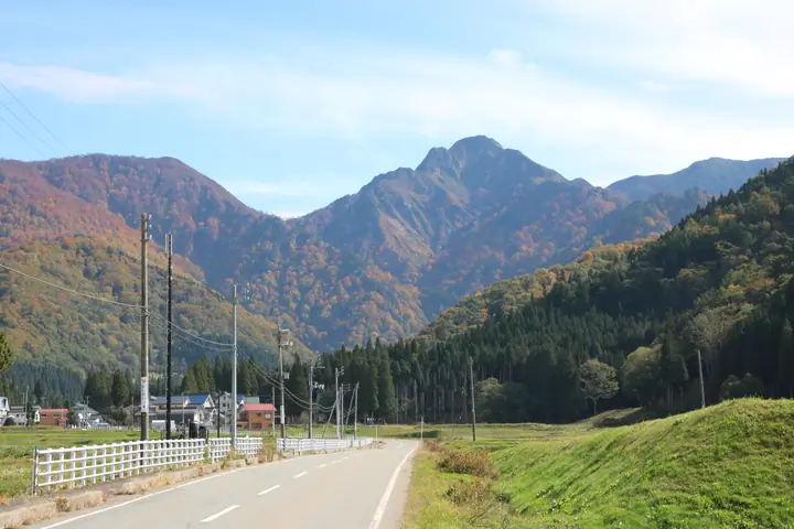
Mount Daigenta is a 1,598 m peak on the border between Minamiuonuma City and Yuzawa Town in Niigata, anchoring the northern end of the Tanigawa range within Jōshin'etsu-Kōgen National Park. Its sharply angular rock spire has earned it the nickname "Matterhorn of the Jōetsu Region" — sometimes "Matterhorn of the East." The classic loop leaves Asahihara in Yuzawa and links Daigenta with neighbouring Mount Nanatsu-goya, weaving stream crossings, steep climbs, knife-edge ridges, and rock scrambles — a route that lets climbers measure their technical chops. The summit unfurls a 360-degree panorama of the Tanigawa range, the Yuzawa Basin, and Mount Makihata. The peak features in Niigata 100 Meizan and Echigo Hyakuzan.
Mount Daigenta at a glance
- Weather: The most settled day in the next 7 days is Wed, November 4: clear, gusts up to 9 m/s. Sat, Nov 7: strong wind (gusts up to 18 m/s).
- Route: The shortest is Daigenta, the Matterhorn of Joetsu, and Nanatsugoya Horseshoe Loop from Asahihara: about 7 h, 10.2 km, about 1,190 m of climbing.
Mount Daigenta weather (hourly, 14 days)
Sunrise today 06:09, sunset 16:46
| Tue, 11/3 | Wed, 11/4 | Thu, 11/5 | Fri, 11/6 | Sat, 11/7 | Sun, 11/8 | Mon, 11/9 | Tue, 11/10 | Wed, 11/11 | Thu, 11/12 | Fri, 11/13 | Sat, 11/14 | Sun, 11/15 | Mon, 11/16 | Tue, 11/17 | |||||||||||||||||||||||||||||||||||||||||||||||||||||||||||||||||||||||
|---|---|---|---|---|---|---|---|---|---|---|---|---|---|---|---|---|---|---|---|---|---|---|---|---|---|---|---|---|---|---|---|---|---|---|---|---|---|---|---|---|---|---|---|---|---|---|---|---|---|---|---|---|---|---|---|---|---|---|---|---|---|---|---|---|---|---|---|---|---|---|---|---|---|---|---|---|---|---|---|---|---|---|---|---|---|
| Japan time | 21 | 23 | 1 | 3 | 5 | 7 | 9 | 11 | 13 | 15 | 17 | 19 | 21 | 0 | 3 | 6 | 9 | 12 | 15 | 18 | 21 | 0 | 3 | 6 | 9 | 12 | 15 | 18 | 21 | 0 | 3 | 6 | 9 | 12 | 15 | 18 | 21 | 0 | 3 | 6 | 9 | 12 | 15 | 18 | 21 | 0 | 3 | 6 | 9 | 12 | 15 | 21 | 3 | 9 | 15 | 21 | 3 | 9 | 15 | 21 | 3 | 9 | 15 | 21 | 3 | 9 | 15 | 21 | 3 | 9 | 15 | 21 | 3 | 9 | 15 | 21 | 3 | 9 | 15 | 21 | 3 | 9 | 15 | 21 | |
 | | |   | |  | |   | |   |   | | |   | | |   | | |   | |   | | |   |   | | | | |   | |   | | | | | | | | | | |   | |   | | | |   | | |   | | | | | | | | | | | | | | | | | | |  | | | | | | | | | | | | | ||
| Temperature | °C | 0° | -1° | -1° | -2° | -1° | 1° | 5° | 9° | 10° | 9° | 4° | 4° | 4° | 3° | 4° | 4° | 8° | 12° | 11° | 8° | 7° | 5° | 5° | 6° | 6° | 7° | 8° | 5° | 3° | 1° | 0° | -1° | -1° | -2° | -2° | -2° | -2° | -3° | -3° | -3° | -2° | -1° | -1° | -2° | -3° | -3° | -3° | -2° | 3° | 5° | 3° | -1° | -2° | 3° | 4° | 1° | -3° | -2° | -2° | -2° | -2° | 0° | 1° | -4° | 0° | -1° | -1° | -3° | -4° | 1° | 4° | -5° | -4° | 6° | 7° | 2° | 4° | 5° | 3° | -2° | -4° | -2° | 1° | -4° |
| Precipitation | mm | 4.2 | 10 | 3.9 | 1.3 | 0.4 | 0.9 | 0.9 | 2.6 | 3.3 | 2.3 | 1.0 | 1.5 | 1.0 | 3.5 | 4.2 | 3.3 | 1.8 | 3.4 | 3.8 | 3.2 | 1.9 | 0.7 | 0.8 | 0.9 | 1.1 | 0.7 | 0.4 | 0.1 | 0.1 | 0.2 | 0.1 | 7 | 6 | 10 | 4.0 | 1.6 | 0.1 | 0.2 | 13 | 4.6 | 1.4 | 0.1 | 4.9 | 4.4 | 0.7 | 15 | 15 | 2.9 | ||||||||||||||||||||||||||||||||||||
| New snow | cm | 0.2 | 1.1 | 0.7 | 2.4 | 2.6 | 2.1 | 1.2 | 0.5 | 0.5 | 0.6 | 0.8 | 0.5 | 0.2 | <.1 | <.1 | 4.6 | 4.3 | 4.9 | 1.0 | 0.5 | 7.0 | 3.1 | 0.8 | <.1 | 1.2 | 1.6 | ||||||||||||||||||||||||||||||||||||||||||||||||||||||||||
| Snow depth | cm | 0 | 0 | 0 | 0 | 0 | 0 | 0 | 0 | 0 | 0 | 0 | 0 | 0 | 0 | 0 | 0 | 0 | 0 | 0 | 0 | 0 | 0 | 0 | 0 | 0 | 0 | 0 | 0 | 0 | 0 | 0 | <1 | 2 | 2 | 4 | 4 | 5 | 5 | 5 | 5 | 5 | 5 | 5 | 5 | 4 | 5 | 5 | 5 | 5 | 5 | 2 | 2 | 2 | 2 | <1 | <1 | 3 | 6 | 7 | 7 | 7 | 7 | 5 | 4 | 4 | 9 | 10 | 10 | 10 | 10 | 7 | 7 | 7 | 7 | 4 | 3 | 2 | <1 | 0 | <1 | 1 | 1 | 1 | <1 |
| Wind | m/s | 0 | 0 | 1 | 1 | 0 | 0 | 1 | 0 | 1 | 3 | 4 | 4 | 5 | 4 | 2 | 2 | 3 | 1 | 1 | 2 | 2 | 0 | 0 | 3 | 3 | 2 | 4 | 3 | 3 | 3 | 4 | 3 | 4 | 4 | 5 | 5 | 5 | 4 | 4 | 3 | 2 | 3 | 2 | 0 | 1 | 2 | 1 | 1 | 0 | 3 | 2 | 1 | 1 | 2 | 4 | 2 | 2 | 6 | 5 | 3 | 1 | 1 | 1 | 1 | 1 | 2 | 5 | 3 | 1 | 1 | 1 | 2 | 1 | 1 | 1 | 3 | 3 | 0 | 5 | 5 | 2 | 1 | 1 | 1 |
| Wind gusts | m/s | 4 | 3 | 2 | 2 | 3 | 2 | 3 | 4 | 7 | 9 | 12 | 15 | 16 | 17 | 14 | 9 | 10 | 8 | 3 | 5 | 8 | 8 | 7 | 11 | 13 | 12 | 11 | 11 | 11 | 12 | 12 | 13 | 15 | 16 | 18 | 17 | 16 | 16 | 15 | 15 | 12 | 10 | 10 | 7 | 5 | 7 | 7 | 6 | 5 | 9 | 9 | 6 | 3 | 8 | 13 | 14 | 10 | 24 | 24 | 18 | 10 | 5 | 5 | 5 | 7 | 8 | 15 | 15 | 10 | 4 | 6 | 6 | 6 | 6 | 7 | 10 | 12 | 9 | 17 | 18 | 16 | 7 | 5 | 4 |
| Wind dir. | ↓ | ↓ | ↓ | ↓ | ↓ | ↓ | ↓ | ↓ | ↓ | ↓ | ↓ | ↓ | ↓ | ↓ | ↓ | ↓ | ↓ | ↓ | ↓ | ↓ | ↓ | ↓ | ↓ | ↓ | ↓ | ↓ | ↓ | ↓ | ↓ | ↓ | ↓ | ↓ | ↓ | ↓ | ↓ | ↓ | ↓ | ↓ | ↓ | ↓ | ↓ | ↓ | ↓ | ↓ | ↓ | ↓ | ↓ | ↓ | ↓ | ↓ | ↓ | ↓ | ↓ | ↓ | ↓ | ↓ | ↓ | ↓ | ↓ | ↓ | ↓ | ↓ | ↓ | ↓ | ↓ | ↓ | ↓ | ↓ | ↓ | ↓ | ↓ | ↓ | ↓ | ↓ | ↓ | ↓ | ↓ | ↓ | ↓ | ↓ | ↓ | ↓ | ↓ | ↓ | |
Mount Daigenta hiking routes
Hiking times are estimates calculated from the terrain.
Huts, campsites and lodging near Mount Daigenta
Mountain huts
- 白崩避難小屋 unstaffed · sleeps 10
- 蓬ヒュッテ 2026: open May 30–November 3 · reservation required
- 白樺避難小屋 unstaffed · sleeps 4
- 笠ヶ岳避難小屋 unstaffed · sleeps 5
Campsites
- Daigenta Canyon Campsite
Lists that include Mount Daigenta
Niigata 100 Famous Mountains · Elevations of 1003 Mountains of Japan
Mount Daigenta facts
- Also known as
- 上越のマッターホルン
- Elevation
- 1,598 m
- Location
- Yuzawa, Niigata
36.902621, 138.927119 - National Park
- 上信越高原国立公園
- Website
- www.town.yuzawa.lg.jp
- Access Information
- niigata-kankou.or.jp
- Wikipedia
- ja.wikipedia.org