
Mt. Takabotchi
高ボッチ山
Okaya, Nagano / Shiojiri, Nagano · Elevation 1,665 m
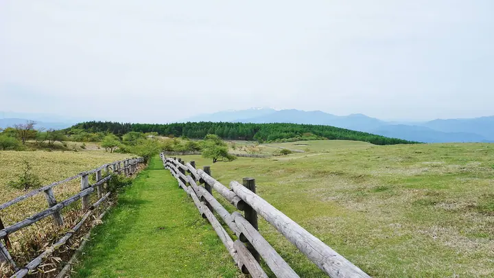
Mt. Takabotchi (1,665 m) is the principal summit of the Takabotchi Highlands in eastern Shiojiri City, Nagano, within Yatsugatake-Chūshin-Kōgen Quasi-National Park. Its gentle, treeless top offers a full 360-degree panorama from the North Alps and Lake Suwa to the Southern Alps and Mt. Fuji, and is known for renge-tsutsuji and Hakusan-fūro flowers in early summer, free-grazing dairy cattle through autumn, and the famed sea-of-clouds visible from mid-October. A road climbs to just below the summit and the Shiojiri City Tourism Association runs a campground and Nature Conservation Centre on site; the access road closes in winter, with the formal mountain opening typically held in late April.
Mt. Takabotchi at a glance
- Weather: The most settled day in the next 7 days is Wed, November 4: clear, gusts up to 5 m/s. Sat, Nov 7: strong wind (gusts up to 18 m/s).
Mt. Takabotchi weather (hourly, 14 days)
Sunrise today 06:12, sunset 16:51
| Tue, 11/3 | Wed, 11/4 | Thu, 11/5 | Fri, 11/6 | Sat, 11/7 | Sun, 11/8 | Mon, 11/9 | Tue, 11/10 | Wed, 11/11 | Thu, 11/12 | Fri, 11/13 | Sat, 11/14 | Sun, 11/15 | Mon, 11/16 | Tue, 11/17 | |||||||||||||||||||||||||||||||||||||||||||||||||||||||||||||||||||||||
|---|---|---|---|---|---|---|---|---|---|---|---|---|---|---|---|---|---|---|---|---|---|---|---|---|---|---|---|---|---|---|---|---|---|---|---|---|---|---|---|---|---|---|---|---|---|---|---|---|---|---|---|---|---|---|---|---|---|---|---|---|---|---|---|---|---|---|---|---|---|---|---|---|---|---|---|---|---|---|---|---|---|---|---|---|---|
| Japan time | 15 | 17 | 19 | 21 | 23 | 1 | 3 | 5 | 7 | 9 | 11 | 13 | 15 | 18 | 21 | 0 | 3 | 6 | 9 | 12 | 15 | 18 | 21 | 0 | 3 | 6 | 9 | 12 | 15 | 18 | 21 | 0 | 3 | 6 | 9 | 12 | 15 | 18 | 21 | 0 | 3 | 6 | 9 | 12 | 15 | 18 | 21 | 0 | 3 | 6 | 9 | 15 | 21 | 3 | 9 | 15 | 21 | 3 | 9 | 15 | 21 | 3 | 9 | 15 | 21 | 3 | 9 | 15 | 21 | 3 | 9 | 15 | 21 | 3 | 9 | 15 | 21 | 3 | 9 | 15 | 21 | 3 | 9 | 15 | |
  |   |  | | | | | | | |  | |   |   | |   | |   |   | |   | |   | | | | | | |  | | | | | | | | | | | | | | | | | | | | | | | | | | | |   |   | | |  | | | | | | | | | | | | | |   | | | |   | | | | | ||
| Temperature | °C | 8° | 4° | 2° | 1° | 1° | 2° | 2° | 0° | 1° | 6° | 10° | 12° | 12° | 7° | 6° | 5° | 5° | 5° | 7° | 11° | 12° | 8° | 8° | 7° | 6° | 7° | 12° | 14° | 13° | 7° | 5° | 4° | 2° | 2° | 5° | 6° | 5° | 0° | -2° | -3° | -3° | -4° | 3° | 7° | 4° | 1° | 1° | 1° | 2° | 2° | 7° | 7° | 1° | 0° | 5° | 8° | 3° | 0° | 1° | 3° | -2° | -3° | 3° | 8° | -2° | -1° | 3° | 3° | -2° | -3° | 3° | 10° | 1° | 1° | 7° | 9° | 6° | 6° | 11° | 7° | 1° | -2° | 1° | 7° |
| Precipitation | mm | 2.0 | 10 | 3.1 | 1.5 | 0.4 | 0.1 | 0.4 | 0.3 | 8 | 9 | 1.2 | 0.5 | ||||||||||||||||||||||||||||||||||||||||||||||||||||||||||||||||||||||||
| New snow | cm | <.1 | <.1 | ||||||||||||||||||||||||||||||||||||||||||||||||||||||||||||||||||||||||||||||||||
| Snow depth | cm | 0 | 0 | 0 | 0 | 0 | 0 | 0 | 0 | 0 | 0 | 0 | 0 | 0 | 0 | 0 | 0 | 0 | 0 | 0 | 0 | 0 | 0 | 0 | 0 | 0 | 0 | 0 | 0 | 0 | 0 | 0 | 0 | 0 | 0 | 0 | 0 | 0 | 0 | 0 | 0 | 0 | 0 | 0 | 0 | 0 | 0 | 0 | 0 | 0 | 0 | 0 | 0 | 0 | 0 | 0 | 0 | 0 | 0 | 0 | 0 | 0 | 0 | 0 | 0 | 0 | 0 | 0 | 0 | 0 | 0 | 0 | 0 | 0 | 0 | 0 | 0 | 0 | 0 | 0 | 0 | 0 | 0 | 0 | 0 |
| Wind | m/s | 3 | 2 | 2 | 1 | 1 | 1 | 1 | 1 | 1 | 1 | 1 | 1 | 1 | 1 | 1 | 2 | 1 | 0 | 0 | 1 | 2 | 2 | 2 | 2 | 3 | 2 | 3 | 4 | 4 | 2 | 2 | 3 | 3 | 4 | 5 | 6 | 5 | 1 | 2 | 2 | 2 | 2 | 2 | 2 | 3 | 2 | 1 | 1 | 1 | 1 | 1 | 3 | 2 | 1 | 1 | 5 | 3 | 4 | 1 | 4 | 1 | 1 | 2 | 1 | 1 | 2 | 2 | 3 | 1 | 0 | 1 | 2 | 2 | 3 | 3 | 4 | 3 | 3 | 3 | 3 | 3 | 2 | 1 | 2 |
| Wind gusts | m/s | 8 | 8 | 5 | 5 | 3 | 3 | 3 | 3 | 3 | 4 | 5 | 5 | 5 | 4 | 4 | 4 | 5 | 7 | 4 | 5 | 7 | 8 | 6 | 8 | 9 | 9 | 10 | 13 | 14 | 12 | 8 | 9 | 10 | 12 | 15 | 18 | 18 | 14 | 4 | 4 | 6 | 6 | 6 | 7 | 10 | 9 | 6 | 5 | 4 | 5 | 6 | 9 | 8 | 5 | 5 | 16 | 15 | 14 | 14 | 14 | 12 | 4 | 7 | 11 | 8 | 6 | 7 | 10 | 10 | 5 | 5 | 8 | 8 | 10 | 11 | 15 | 11 | 14 | 11 | 11 | 11 | 8 | 6 | 7 |
| Wind dir. | ↓ | ↓ | ↓ | ↓ | ↓ | ↓ | ↓ | ↓ | ↓ | ↓ | ↓ | ↓ | ↓ | ↓ | ↓ | ↓ | ↓ | ↓ | ↓ | ↓ | ↓ | ↓ | ↓ | ↓ | ↓ | ↓ | ↓ | ↓ | ↓ | ↓ | ↓ | ↓ | ↓ | ↓ | ↓ | ↓ | ↓ | ↓ | ↓ | ↓ | ↓ | ↓ | ↓ | ↓ | ↓ | ↓ | ↓ | ↓ | ↓ | ↓ | ↓ | ↓ | ↓ | ↓ | ↓ | ↓ | ↓ | ↓ | ↓ | ↓ | ↓ | ↓ | ↓ | ↓ | ↓ | ↓ | ↓ | ↓ | ↓ | ↓ | ↓ | ↓ | ↓ | ↓ | ↓ | ↓ | ↓ | ↓ | ↓ | ↓ | ↓ | ↓ | ↓ | ↓ | |
Huts, campsites and lodging near Mt. Takabotchi
Mountain huts
Campsites
- Takabocchi Plateau Campground
Lodging
- 薬師平茜宿
Mt. Takabotchi facts
- Elevation
- 1,665 m
- Location
- Okaya, Nagano / Shiojiri, Nagano
36.132186, 138.040364 - National Park
- 八ヶ岳中信高原国定公園
- Website
- tokimeguri.jp
- Trail Map
- tokimeguri.jp (PDF)
- Access Information
- tokimeguri.jp
- Wikipedia
- ja.wikipedia.org