
Mt. Shōzu
清水岳
Kurobe, Toyama · Elevation 2,603 m
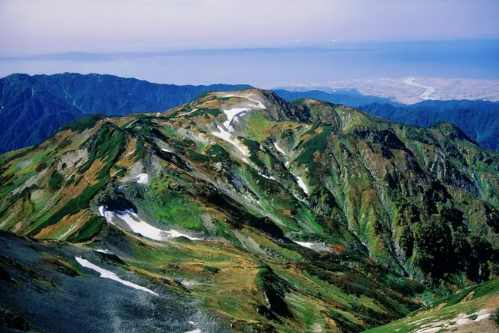
Mt. Shōzu is a 2,603 m peak in Kurobe City, Toyama Prefecture, on the Shōzu Ridge that extends west from Shirouma-dake in the Ushiro-Tateyama subrange of the Hida Mountains (Northern Alps). The forward bastion of Shirouma seen from the Kurobe alluvial fan, its broad gentle summit carries open alpine meadow and flower fields including the rare Miyama-hanashinobu. Within Chūbu-Sangaku National Park, it is reached on the long demanding traverse from Hakuba-Sansō down the Shōzu Ridge to Babadani Onsen — a route prone to trail erosion and only for experienced parties.
Mt. Shōzu at a glance
- Weather: The most settled day in the next 7 days is Wed, November 4: clear, gusts up to 9 m/s. Fri, Nov 6, Sat, Nov 7: strong wind (gusts up to 18 m/s).
Mt. Shōzu weather (hourly, 14 days)
Sunrise today 06:14, sunset 16:52
| Tue, 11/3 | Wed, 11/4 | Thu, 11/5 | Fri, 11/6 | Sat, 11/7 | Sun, 11/8 | Mon, 11/9 | Tue, 11/10 | Wed, 11/11 | Thu, 11/12 | Fri, 11/13 | Sat, 11/14 | Sun, 11/15 | Mon, 11/16 | Tue, 11/17 | |||||||||||||||||||||||||||||||||||||||||||||||||||||||||||||||||||||||
|---|---|---|---|---|---|---|---|---|---|---|---|---|---|---|---|---|---|---|---|---|---|---|---|---|---|---|---|---|---|---|---|---|---|---|---|---|---|---|---|---|---|---|---|---|---|---|---|---|---|---|---|---|---|---|---|---|---|---|---|---|---|---|---|---|---|---|---|---|---|---|---|---|---|---|---|---|---|---|---|---|---|---|---|---|---|
| Japan time | 15 | 17 | 19 | 21 | 23 | 1 | 3 | 5 | 7 | 9 | 11 | 13 | 15 | 18 | 21 | 0 | 3 | 6 | 9 | 12 | 15 | 18 | 21 | 0 | 3 | 6 | 9 | 12 | 15 | 18 | 21 | 0 | 3 | 6 | 9 | 12 | 15 | 18 | 21 | 0 | 3 | 6 | 9 | 12 | 15 | 18 | 21 | 0 | 3 | 6 | 9 | 15 | 21 | 3 | 9 | 15 | 21 | 3 | 9 | 15 | 21 | 3 | 9 | 15 | 21 | 3 | 9 | 15 | 21 | 3 | 9 | 15 | 21 | 3 | 9 | 15 | 21 | 3 | 9 | 15 | 21 | 3 | 9 | 15 | |
  |  |   | | |   | | |  | | |   | |   | |   | | |   |   | | | | | | | | | | |   | |   | |   | | | | | | | | | | | | | | | | | | | | | | | | | | | | | | | | | | |  | | | | | | | | | |   | | | | | ||
| Temperature | °C | 2° | -2° | -5° | -7° | -8° | -8° | -7° | -5° | -3° | 2° | 5° | 6° | 6° | 1° | 1° | 1° | 1° | 2° | 4° | 8° | 9° | 5° | 4° | 4° | 4° | 3° | 4° | 4° | 3° | 0° | -1° | -3° | -4° | -6° | -6° | -6° | -6° | -7° | -9° | -10° | -11° | -11° | -4° | -1° | -3° | -5° | -6° | -5° | -5° | -4° | -1° | -2° | -5° | -9° | -1° | 2° | -3° | -8° | -6° | -5° | -7° | -9° | -3° | -2° | -10° | -5° | -4° | -4° | -9° | -14° | -1° | 2° | -6° | -6° | 2° | 3° | 1° | 1° | 1° | -1° | -5° | -8° | -3° | -1° |
| Precipitation | mm | 1.0 | 10 | 9 | 5.0 | 2.0 | 0.2 | 1.8 | 0.1 | 1.0 | 3.4 | 2.3 | 2.4 | 1.0 | 2.4 | 2.5 | 3.7 | 3.4 | 3.7 | 3.6 | 1.9 | 1.9 | 1.2 | 0.2 | 0.2 | 0.4 | 1.7 | 1.9 | 0.3 | 6 | 13 | 11 | 6 | 1.0 | 2.4 | 9 | 1.0 | 0.1 | 0.3 | 8 | 7 | 10 | 13 | 3.5 | 0.1 | ||||||||||||||||||||||||||||||||||||||||
| New snow | cm | 0.5 | 2.5 | 2.8 | 3.4 | 3.6 | 1.9 | 1.9 | 1.2 | 0.2 | <.1 | <.1 | <.1 | <.1 | 0.4 | 1.5 | 1.5 | <.1 | <.1 | 4.4 | 12 | 11 | 6.1 | 1.0 | 2.2 | 8.2 | 1.0 | <.1 | 0.1 | 1.1 | <.1 | ||||||||||||||||||||||||||||||||||||||||||||||||||||||
| Snow depth | cm | 0 | 0 | 0 | 0 | 0 | 0 | 0 | 0 | 0 | 0 | 0 | 0 | 0 | 0 | 0 | 0 | 0 | 0 | 0 | 0 | 0 | 0 | 0 | 0 | 0 | 0 | 0 | 0 | 0 | 0 | <1 | 2 | 4 | 6 | 9 | 10 | 10 | 11 | 11 | 11 | 11 | 11 | 10 | 10 | 9 | 9 | 9 | 9 | 10 | 11 | 11 | 9 | 8 | 8 | 8 | 6 | 9 | 18 | 26 | 28 | 28 | 27 | 26 | 24 | 23 | 25 | 30 | 30 | 29 | 28 | 28 | 26 | 26 | 25 | 25 | 22 | 21 | 20 | 18 | 15 | 16 | 15 | 15 | 13 |
| Wind | m/s | 1 | 0 | 1 | 1 | 1 | 1 | 0 | 0 | 1 | 2 | 1 | 1 | 2 | 1 | 2 | 2 | 2 | 1 | 1 | 0 | 1 | 0 | 1 | 1 | 1 | 1 | 2 | 2 | 2 | 2 | 2 | 2 | 2 | 2 | 2 | 2 | 2 | 2 | 1 | 1 | 1 | 1 | 1 | 1 | 0 | 1 | 1 | 1 | 1 | 1 | 1 | 1 | 1 | 1 | 1 | 2 | 2 | 4 | 3 | 2 | 0 | 1 | 1 | 1 | 1 | 1 | 2 | 2 | 0 | 0 | 0 | 0 | 1 | 0 | 0 | 0 | 1 | 1 | 1 | 2 | 1 | 0 | 0 | 0 |
| Wind gusts | m/s | 10 | 9 | 8 | 9 | 8 | 8 | 7 | 6 | 7 | 8 | 9 | 7 | 7 | 10 | 12 | 13 | 11 | 10 | 11 | 12 | 12 | 11 | 9 | 10 | 10 | 11 | 13 | 15 | 18 | 17 | 17 | 16 | 17 | 17 | 16 | 18 | 18 | 16 | 14 | 13 | 13 | 12 | 11 | 10 | 10 | 10 | 10 | 10 | 10 | 11 | 11 | 11 | 8 | 6 | 8 | 13 | 17 | 27 | 28 | 20 | 14 | 7 | 8 | 10 | 10 | 11 | 12 | 12 | 11 | 8 | 6 | 7 | 7 | 7 | 8 | 11 | 17 | 17 | 15 | 18 | 17 | 9 | 6 | 6 |
| Wind dir. | ↓ | ↓ | ↓ | ↓ | ↓ | ↓ | ↓ | ↓ | ↓ | ↓ | ↓ | ↓ | ↓ | ↓ | ↓ | ↓ | ↓ | ↓ | ↓ | ↓ | ↓ | ↓ | ↓ | ↓ | ↓ | ↓ | ↓ | ↓ | ↓ | ↓ | ↓ | ↓ | ↓ | ↓ | ↓ | ↓ | ↓ | ↓ | ↓ | ↓ | ↓ | ↓ | ↓ | ↓ | ↓ | ↓ | ↓ | ↓ | ↓ | ↓ | ↓ | ↓ | ↓ | ↓ | ↓ | ↓ | ↓ | ↓ | ↓ | ↓ | ↓ | ↓ | ↓ | ↓ | ↓ | ↓ | ↓ | ↓ | ↓ | ↓ | ↓ | ↓ | ↓ | ↓ | ↓ | ↓ | ↓ | ↓ | ↓ | ↓ | ↓ | ↓ | ↓ | ↓ | |
Huts, campsites and lodging near Mt. Shōzu
Mountain huts
- Kaerazudake Hinan Goya unstaffed · sleeps 20
- Shiroumadake Chojoshukusha 2026: open June 27–September 27 · reservation required · sleeps 280
- Hakuba Sanso 2026: open April 25–October 12 · reservation required · sleeps 800
- Yukikuradake Hinan Goya unstaffed · sleeps 30
- 緊急避難小屋
Campsites
- 白馬岳頂上宿舎テント場
Lists that include Mt. Shōzu
100 Mountains of Toyama · Elevations of 1003 Mountains of Japan
Mt. Shōzu facts
- Elevation
- 2,603 m
- Location
- Kurobe, Toyama
36.764763, 137.718934 - National Park
- 中部山岳国立公園
- Website
- hakubakan.com
- Wikipedia
- ja.wikipedia.org