
Mt. Kuwanomine
鍬ノ峰
Ōmachi-shi, Nagano · Elevation 1,623 m
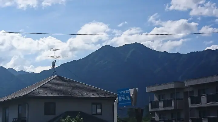
Mt. Kuwanomine is a 1,623 m foothill peak in Omachi City, Nagano, sitting at the eastern end of a ridge running off Mt. Gaki on the front edge of the Northern Alps. Seen from Omachi, its hoe-shaped silhouette gives the mountain its name and the nickname Tokiwa Fuji. Trails climb from the Shirasawa trailhead and from Hotokezaki Kannon-ji, with rhododendron blooms peaking from late May through June. The peak is included in the Nagano 100 Meiho selection.
Mt. Kuwanomine at a glance
- Weather: The most settled day in the next 7 days is Wed, November 4: clear, gusts up to 8 m/s. Sat, Nov 7: strong wind (gusts up to 16 m/s).
Mt. Kuwanomine weather (hourly, 14 days)
Sunrise today 06:13, sunset 16:52
| Tue, 11/3 | Wed, 11/4 | Thu, 11/5 | Fri, 11/6 | Sat, 11/7 | Sun, 11/8 | Mon, 11/9 | Tue, 11/10 | Wed, 11/11 | Thu, 11/12 | Fri, 11/13 | Sat, 11/14 | Sun, 11/15 | Mon, 11/16 | Tue, 11/17 | |||||||||||||||||||||||||||||||||||||||||||||||||||||||||||||||||||||||
|---|---|---|---|---|---|---|---|---|---|---|---|---|---|---|---|---|---|---|---|---|---|---|---|---|---|---|---|---|---|---|---|---|---|---|---|---|---|---|---|---|---|---|---|---|---|---|---|---|---|---|---|---|---|---|---|---|---|---|---|---|---|---|---|---|---|---|---|---|---|---|---|---|---|---|---|---|---|---|---|---|---|---|---|---|---|
| Japan time | 15 | 17 | 19 | 21 | 23 | 1 | 3 | 5 | 7 | 9 | 11 | 13 | 15 | 18 | 21 | 0 | 3 | 6 | 9 | 12 | 15 | 18 | 21 | 0 | 3 | 6 | 9 | 12 | 15 | 18 | 21 | 0 | 3 | 6 | 9 | 12 | 15 | 18 | 21 | 0 | 3 | 6 | 9 | 12 | 15 | 18 | 21 | 0 | 3 | 6 | 9 | 15 | 21 | 3 | 9 | 15 | 21 | 3 | 9 | 15 | 21 | 3 | 9 | 15 | 21 | 3 | 9 | 15 | 21 | 3 | 9 | 15 | 21 | 3 | 9 | 15 | 21 | 3 | 9 | 15 | 21 | 3 | 9 | 15 | |
  |   | |  | |   | | |   | |  | | |   |   | | | |   | |   | | | | | | |   |   | |   |   | |   |   | | | | |   | |  | | | | | | | | |   | | | | | | | | |   | | | | | | |   | | |  | | | | | | | | | | | | | | | ||
| Temperature | °C | 7° | 3° | 1° | 1° | 0° | 0° | 1° | 1° | 2° | 6° | 9° | 11° | 10° | 5° | 6° | 5° | 6° | 6° | 8° | 9° | 12° | 8° | 8° | 8° | 7° | 7° | 9° | 11° | 10° | 6° | 4° | 2° | 0° | -1° | 0° | 1° | 0° | -2° | -4° | -5° | -5° | -3° | 3° | 7° | 4° | 1° | 1° | 1° | 1° | 1° | 3° | 4° | -4° | -4° | 3° | 6° | 2° | -2° | -1° | 1° | -3° | -4° | 3° | 5° | -4° | 0° | 1° | 3° | -3° | -3° | 5° | 8° | 0° | -1° | 7° | 8° | 5° | 6° | 8° | 6° | 0° | -1° | 2° | 5° |
| Precipitation | mm | 0.7 | 0.4 | 0.4 | 0.1 | 2.1 | 10 | 8 | 7 | 1.5 | 0.4 | 0.6 | 0.9 | 2.8 | 0.5 | 1.0 | 0.3 | 0.2 | 1.1 | 1.6 | 1.5 | 1.4 | 0.7 | 0.1 | 0.1 | 0.1 | 1.1 | 1.5 | 0.3 | 3.6 | 4.2 | 3.4 | 0.2 | 0.1 | 1.3 | 5 | 3.9 | 0.7 | 0.5 | 1.0 | 0.2 | 0.7 | 10 | 10 | 1.6 | 2.1 | 2.2 | 1.0 | |||||||||||||||||||||||||||||||||||||
| New snow | cm | <.1 | 0.1 | 0.8 | 1.1 | 1.2 | 1.1 | 0.7 | 0.1 | <.1 | <.1 | <.1 | 0.1 | 0.8 | 1.0 | 0.1 | 0.4 | <.1 | 1.2 | 3.7 | 3.5 | 0.6 | <.1 | 0.5 | 0.7 | <.1 | 0.4 | 0.7 | |||||||||||||||||||||||||||||||||||||||||||||||||||||||||
| Snow depth | cm | 0 | 0 | 0 | 0 | 0 | 0 | 0 | 0 | 0 | 0 | 0 | 0 | 0 | 0 | 0 | 0 | 0 | 0 | 0 | 0 | 0 | 0 | 0 | 0 | 0 | 0 | 0 | 0 | 0 | 0 | <1 | <1 | 2 | 2 | 3 | 4 | 4 | 4 | 4 | 4 | 4 | 3 | 3 | 3 | 3 | 3 | 3 | 3 | 4 | 4 | 4 | 4 | 4 | 4 | 4 | 4 | 4 | 7 | 10 | 9 | 9 | 9 | 8 | 8 | 8 | 8 | 8 | 8 | 8 | 8 | 8 | 7 | 7 | 7 | 7 | 6 | 5 | 5 | 4 | 2 | 3 | 3 | 3 | 2 |
| Wind | m/s | 1 | 1 | 1 | 1 | 1 | 1 | 0 | 0 | 0 | 1 | 1 | 1 | 2 | 0 | 1 | 0 | 0 | 0 | 1 | 1 | 0 | 0 | 1 | 1 | 1 | 1 | 1 | 2 | 1 | 2 | 1 | 1 | 2 | 2 | 2 | 2 | 2 | 2 | 3 | 3 | 2 | 2 | 1 | 1 | 1 | 1 | 1 | 1 | 1 | 1 | 1 | 1 | 1 | 1 | 1 | 2 | 1 | 3 | 2 | 1 | 1 | 1 | 1 | 1 | 1 | 2 | 1 | 1 | 1 | 1 | 1 | 1 | 1 | 1 | 0 | 0 | 1 | 2 | 1 | 2 | 1 | 0 | 1 | 1 |
| Wind gusts | m/s | 8 | 7 | 7 | 7 | 7 | 6 | 6 | 5 | 5 | 7 | 8 | 8 | 8 | 7 | 7 | 7 | 5 | 5 | 9 | 12 | 11 | 8 | 6 | 8 | 8 | 8 | 10 | 12 | 14 | 10 | 10 | 10 | 12 | 13 | 14 | 16 | 15 | 13 | 12 | 12 | 12 | 11 | 10 | 9 | 9 | 9 | 8 | 8 | 9 | 9 | 9 | 9 | 7 | 6 | 7 | 12 | 11 | 20 | 22 | 17 | 10 | 5 | 7 | 9 | 10 | 8 | 9 | 11 | 9 | 7 | 6 | 6 | 7 | 6 | 7 | 10 | 10 | 12 | 11 | 13 | 12 | 7 | 5 | 6 |
| Wind dir. | ↓ | ↓ | ↓ | ↓ | ↓ | ↓ | ↓ | ↓ | ↓ | ↓ | ↓ | ↓ | ↓ | ↓ | ↓ | ↓ | ↓ | ↓ | ↓ | ↓ | ↓ | ↓ | ↓ | ↓ | ↓ | ↓ | ↓ | ↓ | ↓ | ↓ | ↓ | ↓ | ↓ | ↓ | ↓ | ↓ | ↓ | ↓ | ↓ | ↓ | ↓ | ↓ | ↓ | ↓ | ↓ | ↓ | ↓ | ↓ | ↓ | ↓ | ↓ | ↓ | ↓ | ↓ | ↓ | ↓ | ↓ | ↓ | ↓ | ↓ | ↓ | ↓ | ↓ | ↓ | ↓ | ↓ | ↓ | ↓ | ↓ | ↓ | ↓ | ↓ | ↓ | ↓ | ↓ | ↓ | ↓ | ↓ | ↓ | ↓ | ↓ | ↓ | ↓ | ↓ | |
Huts, campsites and lodging near Mt. Kuwanomine
Campsites
- 出会いの広場
- 森のくらしの郷
Lodging
- Omachi-sanso
- ときしらずの宿 織花
- Kuroyon Royal Hotel
Mt. Kuwanomine facts
- Also known as
- 常盤富士
- Elevation
- 1,623 m
- Location
- Ōmachi-shi, Nagano
36.484840, 137.794873 - Website
- kanko-omachi.gr.jp
- Wikipedia
- ja.wikipedia.org