
Rengedake
蓮華岳
Ōmachi-shi, Nagano · Elevation 2,799 m
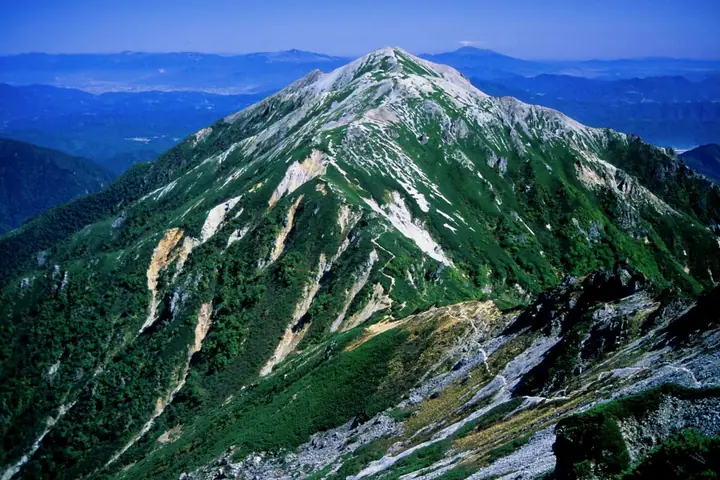
A 2,799 m peak at the southern end of the Ushiro-Tateyama Range in the Hida Mountains, straddling Tateyama Town in Toyama Prefecture and Ōmachi City in Nagano Prefecture. The peak lies within the Special Protection Zone of Chūbu-Sangaku National Park, and its broad sandy summit ridge holds one of Japan's largest colonies of komakusa (cushion pink). Selected for the Japan 300 Famous Mountains, the New Flower Hundred, and the Japan 100 High Mountains, it is most often climbed together with neighboring Harinokidake via the Harinoki Snow Valley from the Ōgisawa trailhead.
Rengedake at a glance
- Weather: The most settled day in the next 7 days is Wed, November 4: clear, gusts up to 6 m/s. Fri, Nov 6, Sat, Nov 7: strong wind (gusts up to 18 m/s).
Rengedake weather (hourly, 14 days)
Sunrise today 06:14, sunset 16:52
| Tue, 11/3 | Wed, 11/4 | Thu, 11/5 | Fri, 11/6 | Sat, 11/7 | Sun, 11/8 | Mon, 11/9 | Tue, 11/10 | Wed, 11/11 | Thu, 11/12 | Fri, 11/13 | Sat, 11/14 | Sun, 11/15 | Mon, 11/16 | Tue, 11/17 | |||||||||||||||||||||||||||||||||||||||||||||||||||||||||||||||||||||||
|---|---|---|---|---|---|---|---|---|---|---|---|---|---|---|---|---|---|---|---|---|---|---|---|---|---|---|---|---|---|---|---|---|---|---|---|---|---|---|---|---|---|---|---|---|---|---|---|---|---|---|---|---|---|---|---|---|---|---|---|---|---|---|---|---|---|---|---|---|---|---|---|---|---|---|---|---|---|---|---|---|---|---|---|---|---|
| Japan time | 15 | 17 | 19 | 21 | 23 | 1 | 3 | 5 | 7 | 9 | 11 | 13 | 15 | 18 | 21 | 0 | 3 | 6 | 9 | 12 | 15 | 18 | 21 | 0 | 3 | 6 | 9 | 12 | 15 | 18 | 21 | 0 | 3 | 6 | 9 | 12 | 15 | 18 | 21 | 0 | 3 | 6 | 9 | 12 | 15 | 18 | 21 | 0 | 3 | 6 | 9 | 15 | 21 | 3 | 9 | 15 | 21 | 3 | 9 | 15 | 21 | 3 | 9 | 15 | 21 | 3 | 9 | 15 | 21 | 3 | 9 | 15 | 21 | 3 | 9 | 15 | 21 | 3 | 9 | 15 | 21 | 3 | 9 | 15 | |
  |   | |  | | | | | |  | | | |   |   | | | |   | |   | | |   | | | | | |   | | |   | |   | | | | | | | | | |   | |   | | | | |   | |   | | | | | | | |  | | | | |   |   | | | | | | | | | | | | |   | | | | ||
| Temperature | °C | 0° | -4° | -7° | -9° | -10° | -9° | -8° | -8° | -7° | -2° | 1° | 3° | 2° | -3° | -3° | -3° | -2° | -2° | 0° | 3° | 5° | 2° | 1° | 0° | 0° | -1° | 1° | 2° | 1° | -3° | -4° | -6° | -8° | -9° | -8° | -8° | -9° | -10° | -12° | -13° | -14° | -13° | -5° | -2° | -4° | -6° | -7° | -7° | -7° | -7° | -4° | -3° | -11° | -12° | -4° | -1° | -6° | -11° | -8° | -7° | -11° | -13° | -6° | -3° | -13° | -8° | -6° | -5° | -12° | -13° | -3° | 0° | -9° | -10° | -1° | 0° | -2° | -3° | 0° | -3° | -8° | -11° | -5° | -3° |
| Precipitation | mm | 0.1 | 1.8 | 10 | 9 | 6 | 2.2 | 0.1 | 0.1 | 1.1 | 0.8 | 2.3 | 1.0 | 1.0 | 0.3 | 1.0 | 0.9 | 2.5 | 2.1 | 2.4 | 2.4 | 1.5 | 0.8 | 0.4 | 0.2 | 1.2 | 1.9 | 0.2 | 0.3 | 0.6 | 2.8 | 8 | 7 | 1.5 | 1.0 | 3.3 | 0.2 | 0.5 | 10 | 9 | 3.0 | 5.0 | 2.5 | ||||||||||||||||||||||||||||||||||||||||||
| New snow | cm | <.1 | 0.3 | 1.5 | 1.7 | 2.2 | 2.2 | 1.4 | 0.7 | 0.4 | <.1 | <.1 | <.1 | 0.2 | 1.0 | 1.3 | <.1 | <.1 | 0.3 | 1.9 | 6.6 | 6.9 | 1.4 | <.1 | 0.9 | 2.3 | <.1 | 0.6 | 1.1 | ||||||||||||||||||||||||||||||||||||||||||||||||||||||||
| Snow depth | cm | 0 | 0 | 0 | 0 | 0 | 0 | 0 | 0 | 0 | 0 | 0 | 0 | 0 | 0 | 0 | 0 | 0 | 0 | 0 | 0 | 0 | 0 | 0 | 0 | 0 | 0 | 0 | 0 | 0 | 0 | <1 | 1 | 3 | 4 | 6 | 6 | 6 | 6 | 6 | 6 | 6 | 6 | 6 | 6 | 5 | 5 | 5 | 5 | 5 | 7 | 6 | 5 | 5 | 5 | 5 | 4 | 5 | 10 | 15 | 15 | 14 | 13 | 13 | 12 | 12 | 12 | 14 | 13 | 12 | 12 | 12 | 11 | 11 | 11 | 11 | 9 | 9 | 8 | 7 | 6 | 7 | 7 | 7 | 7 |
| Wind | m/s | 0 | 1 | 1 | 1 | 1 | 1 | 1 | 0 | 0 | 1 | 1 | 1 | 2 | 0 | 1 | 0 | 0 | 0 | 1 | 0 | 1 | 1 | 0 | 1 | 1 | 1 | 1 | 3 | 2 | 2 | 2 | 1 | 2 | 1 | 2 | 4 | 3 | 2 | 2 | 2 | 2 | 2 | 1 | 1 | 0 | 0 | 1 | 1 | 1 | 1 | 1 | 1 | 1 | 1 | 1 | 1 | 1 | 4 | 2 | 1 | 1 | 1 | 1 | 1 | 1 | 2 | 1 | 0 | 1 | 1 | 0 | 0 | 1 | 1 | 0 | 0 | 1 | 2 | 1 | 1 | 1 | 0 | 0 | 1 |
| Wind gusts | m/s | 7 | 6 | 6 | 7 | 7 | 7 | 6 | 5 | 4 | 4 | 6 | 6 | 6 | 5 | 5 | 5 | 4 | 4 | 7 | 9 | 8 | 6 | 5 | 7 | 6 | 7 | 10 | 14 | 15 | 13 | 13 | 13 | 14 | 14 | 14 | 18 | 18 | 14 | 12 | 11 | 11 | 11 | 9 | 7 | 7 | 6 | 6 | 6 | 7 | 7 | 7 | 8 | 6 | 6 | 6 | 7 | 10 | 22 | 24 | 16 | 8 | 6 | 6 | 6 | 7 | 9 | 9 | 8 | 7 | 6 | 5 | 5 | 6 | 6 | 6 | 7 | 8 | 10 | 10 | 13 | 10 | 6 | 4 | 6 |
| Wind dir. | ↓ | ↓ | ↓ | ↓ | ↓ | ↓ | ↓ | ↓ | ↓ | ↓ | ↓ | ↓ | ↓ | ↓ | ↓ | ↓ | ↓ | ↓ | ↓ | ↓ | ↓ | ↓ | ↓ | ↓ | ↓ | ↓ | ↓ | ↓ | ↓ | ↓ | ↓ | ↓ | ↓ | ↓ | ↓ | ↓ | ↓ | ↓ | ↓ | ↓ | ↓ | ↓ | ↓ | ↓ | ↓ | ↓ | ↓ | ↓ | ↓ | ↓ | ↓ | ↓ | ↓ | ↓ | ↓ | ↓ | ↓ | ↓ | ↓ | ↓ | ↓ | ↓ | ↓ | ↓ | ↓ | ↓ | ↓ | ↓ | ↓ | ↓ | ↓ | ↓ | ↓ | ↓ | ↓ | ↓ | ↓ | ↓ | ↓ | ↓ | ↓ | ↓ | ↓ | ||
Huts, campsites and lodging near Rengedake
Mountain huts
- Harinoki Lodge 2026: open July 1–September 27 · reservation required · sleeps 60
- Osawa Goya reservation required
- 船窪小屋
- Shinkoshi-Sanso 2026: open July 15–September 26 · reservation required · sleeps 35
- 七倉山荘 2026: open April 15–November 15 · reservation required
Campsites
- 針ノ木小屋テント場
- 船窪小屋テント場
Lists that include Rengedake
Japan's 300 Famous Mountains · New 100 Famous Flower Mountains · Japan's 100 Highest Mountains · Koshinetsu 100 Famous Mountains · Shinshu 100 Famous Mountains · 100 Mountains of Toyama · Elevations of 1003 Mountains of Japan · 1000 Mountains of Japan
Rengedake facts
- Elevation
- 2,799 m
- Location
- Ōmachi-shi, Nagano
36.535765, 137.710539 - National Park
- 中部山岳国立公園
- Website
- kanko-omachi.gr.jp
- Trail Map
- www.pref.toyama.jp (PDF)
- Access Information
- kanko-omachi.gr.jp
- Wikipedia
- ja.wikipedia.org