
Mount Ariake
有明山
Azumino, Nagano · Elevation 2,268 m
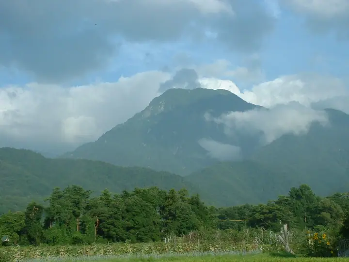
Mount Ariake is a 2,268 m peak straddling Azumino City and Matsukawa Village in Nagano Prefecture, rising as a forward bastion of the Jōnen Range in the Northern Japanese Alps. Its broad trapezoidal silhouette earns it the names "Shinano Fuji," "Ariake Fuji," and "Azumi Fuji"; it is listed in the Nihon Nihyaku Meizan and Shinshū Hyakumeizan. Traditionally opened by the ascetic Yūkai in 1721, it remains a mountain of worship linking Ariake-yama Shrine below with an inner sanctuary on the summit. Its routes are steep and include serious chain sections. The Matsukawa-side course is currently impassable after storm damage washed away bridges and collapsed trail sections, so the village strongly recommends approaching from the Azumino side.
Mount Ariake at a glance
- Weather: The most settled day in the next 7 days is Wed, November 4: clear, gusts up to 7 m/s.
Mount Ariake weather (hourly, 14 days)
Sunrise today 06:13, sunset 16:52
| Tue, 11/3 | Wed, 11/4 | Thu, 11/5 | Fri, 11/6 | Sat, 11/7 | Sun, 11/8 | Mon, 11/9 | Tue, 11/10 | Wed, 11/11 | Thu, 11/12 | Fri, 11/13 | Sat, 11/14 | Sun, 11/15 | Mon, 11/16 | Tue, 11/17 | |||||||||||||||||||||||||||||||||||||||||||||||||||||||||||||||||||||||
|---|---|---|---|---|---|---|---|---|---|---|---|---|---|---|---|---|---|---|---|---|---|---|---|---|---|---|---|---|---|---|---|---|---|---|---|---|---|---|---|---|---|---|---|---|---|---|---|---|---|---|---|---|---|---|---|---|---|---|---|---|---|---|---|---|---|---|---|---|---|---|---|---|---|---|---|---|---|---|---|---|---|---|---|---|---|
| Japan time | 15 | 17 | 19 | 21 | 23 | 1 | 3 | 5 | 7 | 9 | 11 | 13 | 15 | 18 | 21 | 0 | 3 | 6 | 9 | 12 | 15 | 18 | 21 | 0 | 3 | 6 | 9 | 12 | 15 | 18 | 21 | 0 | 3 | 6 | 9 | 12 | 15 | 18 | 21 | 0 | 3 | 6 | 9 | 12 | 15 | 18 | 21 | 0 | 3 | 6 | 9 | 15 | 21 | 3 | 9 | 15 | 21 | 3 | 9 | 15 | 21 | 3 | 9 | 15 | 21 | 3 | 9 | 15 | 21 | 3 | 9 | 15 | 21 | 3 | 9 | 15 | 21 | 3 | 9 | 15 | 21 | 3 | 9 | 15 | |
  |   |  | | | | | |   | |  | | |   | |   | | |   | |   |   | | | | |   | | | | |   | |   |   |   | | | | |  | | | | | | |   | | | | | | | |   | | | |   | |  | | | | | | | | | | | | | | | | | |   |   |   | | | ||
| Temperature | °C | 6° | 1° | -1° | -2° | -2° | -2° | -1° | -1° | 0° | 4° | 7° | 8° | 7° | 4° | 4° | 3° | 3° | 4° | 5° | 8° | 10° | 6° | 6° | 5° | 5° | 5° | 7° | 9° | 7° | 3° | 1° | 0° | -1° | -2° | -1° | 0° | 0° | -4° | -5° | -5° | -5° | -5° | 2° | 5° | 2° | -1° | -1° | -1° | -1° | -1° | 2° | 3° | -6° | -7° | 2° | 3° | -1° | -5° | -2° | 0° | -6° | -6° | 1° | 3° | -5° | -1° | 0° | 1° | -4° | -3° | 2° | 6° | -2° | -2° | 5° | 5° | 3° | 4° | 6° | 5° | 0° | -3° | 0° | 3° |
| Precipitation | mm | 0.2 | 2.4 | 10 | 9 | 7 | 1.1 | 0.1 | 1.0 | 1.4 | 0.3 | 0.2 | 0.3 | 0.6 | 0.7 | 0.6 | 0.3 | 0.5 | 0.7 | 0.1 | 1.4 | 4.0 | 2.3 | 0.2 | 0.4 | 0.2 | 0.6 | 9 | 11 | 1.4 | 0.5 | 0.9 | 0.5 | ||||||||||||||||||||||||||||||||||||||||||||||||||||
| New snow | cm | <.1 | <.1 | <.1 | <.1 | 0.2 | 0.5 | 0.7 | 0.6 | 0.3 | <.1 | <.1 | <.1 | <.1 | <.1 | 0.4 | 0.4 | <.1 | <.1 | <.1 | 0.7 | 2.9 | 2.2 | <.1 | 0.1 | 0.1 | <.1 | <.1 | <.1 | <.1 | <.1 | ||||||||||||||||||||||||||||||||||||||||||||||||||||||
| Snow depth | cm | 0 | 0 | 0 | 0 | 0 | 0 | 0 | 0 | 0 | 0 | 0 | 0 | 0 | 0 | 0 | 0 | 0 | 0 | 0 | 0 | 0 | 0 | 0 | 0 | 0 | 0 | 0 | 0 | 0 | 0 | 0 | <1 | <1 | <1 | 1 | 1 | <1 | <1 | <1 | <1 | <1 | <1 | <1 | <1 | <1 | <1 | <1 | <1 | <1 | <1 | <1 | <1 | <1 | <1 | <1 | <1 | 1 | 3 | 5 | 4 | 4 | 4 | 4 | 3 | 3 | 3 | 3 | 2 | 2 | 2 | 2 | 2 | 2 | 2 | 1 | 1 | <1 | <1 | <1 | <1 | <1 | <1 | <1 | <1 |
| Wind | m/s | 0 | 1 | 1 | 1 | 1 | 1 | 1 | 0 | 0 | 1 | 2 | 1 | 1 | 0 | 1 | 0 | 0 | 0 | 1 | 1 | 1 | 1 | 1 | 1 | 1 | 1 | 1 | 2 | 2 | 2 | 2 | 2 | 2 | 2 | 2 | 2 | 1 | 3 | 3 | 3 | 2 | 1 | 0 | 0 | 0 | 1 | 1 | 1 | 1 | 1 | 1 | 0 | 2 | 2 | 1 | 3 | 1 | 4 | 1 | 1 | 1 | 1 | 0 | 0 | 1 | 1 | 1 | 1 | 0 | 0 | 1 | 0 | 1 | 2 | 1 | 1 | 1 | 2 | 1 | 1 | 1 | 0 | 1 | 1 |
| Wind gusts | m/s | 6 | 5 | 6 | 7 | 7 | 6 | 5 | 4 | 4 | 6 | 7 | 7 | 7 | 6 | 6 | 6 | 5 | 5 | 8 | 10 | 9 | 7 | 7 | 8 | 8 | 8 | 9 | 11 | 11 | 11 | 11 | 12 | 12 | 13 | 13 | 13 | 12 | 12 | 13 | 12 | 11 | 10 | 9 | 6 | 6 | 7 | 7 | 8 | 9 | 9 | 9 | 8 | 6 | 7 | 7 | 14 | 12 | 20 | 21 | 12 | 7 | 5 | 6 | 6 | 7 | 8 | 8 | 8 | 7 | 5 | 5 | 6 | 6 | 7 | 8 | 10 | 11 | 12 | 11 | 11 | 9 | 5 | 5 | 7 |
| Wind dir. | ↓ | ↓ | ↓ | ↓ | ↓ | ↓ | ↓ | ↓ | ↓ | ↓ | ↓ | ↓ | ↓ | ↓ | ↓ | ↓ | ↓ | ↓ | ↓ | ↓ | ↓ | ↓ | ↓ | ↓ | ↓ | ↓ | ↓ | ↓ | ↓ | ↓ | ↓ | ↓ | ↓ | ↓ | ↓ | ↓ | ↓ | ↓ | ↓ | ↓ | ↓ | ↓ | ↓ | ↓ | ↓ | ↓ | ↓ | ↓ | ↓ | ↓ | ↓ | ↓ | ↓ | ↓ | ↓ | ↓ | ↓ | ↓ | ↓ | ↓ | ↓ | ↓ | ↓ | ↓ | ↓ | ↓ | ↓ | ↓ | ↓ | ↓ | ↓ | ↓ | ↓ | ↓ | ↓ | ↓ | ↓ | ↓ | ↓ | ↓ | ↓ | ↓ | ↓ | ↓ | |
Huts, campsites and lodging near Mount Ariake
Mountain huts
- 合戦小屋
Campsites
- 合戦小屋テント場
Lodging
- 安曇野市営有明荘
- 中房温泉
Lists that include Mount Ariake
Japan 200 Famous Mountains · Japan's 300 Famous Mountains · 100 Fujis of Japan · Koshinetsu 100 Famous Mountains · Shinshu 100 Famous Mountains · Elevations of 1003 Mountains of Japan · 1000 Mountains of Japan
Mount Ariake facts
- Also known as
- 有明山北岳 · 有明富士 · 信濃富士 · 安曇富士
- Elevation
- 2,268 m
- Location
- Azumino, Nagano
36.391112, 137.770690 - National Park
- 中部山岳国立公園
- Website
- www.vill.matsukawa.nagano.jp
- Access Information
- mt-parking-info.azumino-e-tabi.net
- Wikipedia
- ja.wikipedia.org