
Mt. Kosumoyama
越百山
Okuwa, Nagano / Iijima, Nagano · Elevation 2,613 m
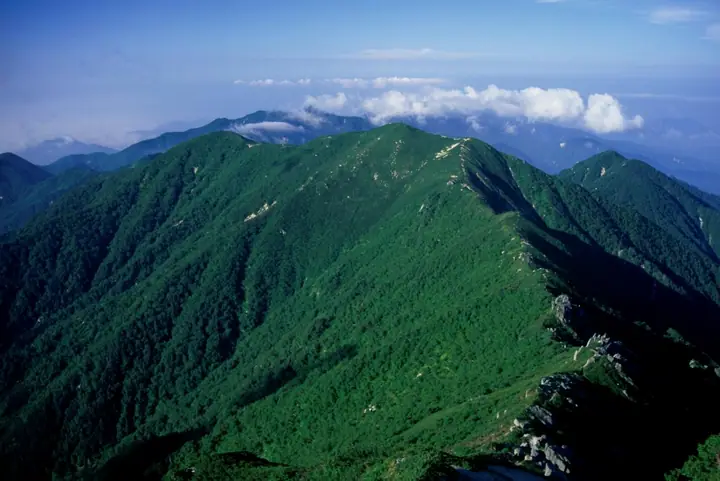
Kosumo-yama (2,613 m) lies on the boundary of Iijima Town and Ōkuwa Village in Nagano Prefecture, on the southern stretch of the main ridge of the Kiso Range (Central Alps). It is included in the 300 Famous Mountains of Japan and the 100 Famous Mountains of Shinshū, with Minami-Koma-ga-take to the north and Oku-Nenjō-dake to the south. The summit looks east across the Akaishi Range to Mount Fuji and is approached via the Fukutochi spur from the Inagawa Dam side or along the Central Alps ridge. Kosumo Hut, at about 2,340 m, is currently closed; the adjacent emergency shelter is intended only for unforeseen emergencies.
Mt. Kosumoyama at a glance
- Weather: The most settled day in the next 7 days is Sun, November 8: clear, gusts up to 7 m/s.
Mt. Kosumoyama weather (hourly, 14 days)
Sunrise today 06:12, sunset 16:53
| Tue, 11/3 | Wed, 11/4 | Thu, 11/5 | Fri, 11/6 | Sat, 11/7 | Sun, 11/8 | Mon, 11/9 | Tue, 11/10 | Wed, 11/11 | Thu, 11/12 | Fri, 11/13 | Sat, 11/14 | Sun, 11/15 | Mon, 11/16 | Tue, 11/17 | |||||||||||||||||||||||||||||||||||||||||||||||||||||||||||||||||||||||
|---|---|---|---|---|---|---|---|---|---|---|---|---|---|---|---|---|---|---|---|---|---|---|---|---|---|---|---|---|---|---|---|---|---|---|---|---|---|---|---|---|---|---|---|---|---|---|---|---|---|---|---|---|---|---|---|---|---|---|---|---|---|---|---|---|---|---|---|---|---|---|---|---|---|---|---|---|---|---|---|---|---|---|---|---|---|
| Japan time | 21 | 23 | 1 | 3 | 5 | 7 | 9 | 11 | 13 | 15 | 17 | 19 | 21 | 0 | 3 | 6 | 9 | 12 | 15 | 18 | 21 | 0 | 3 | 6 | 9 | 12 | 15 | 18 | 21 | 0 | 3 | 6 | 9 | 12 | 15 | 18 | 21 | 0 | 3 | 6 | 9 | 12 | 15 | 18 | 21 | 0 | 3 | 6 | 9 | 12 | 15 | 21 | 3 | 9 | 15 | 21 | 3 | 9 | 15 | 21 | 3 | 9 | 15 | 21 | 3 | 9 | 15 | 21 | 3 | 9 | 15 | 21 | 3 | 9 | 15 | 21 | 3 | 9 | 15 | 21 | 3 | 9 | 15 | 21 | |
  | | | | |   |   | |   | |   | |   | | | |   | | | | | | | |   | | | |   | | | | |  | |  | | | | | | | | | | | | |   | | | |   | | | | | | |   |  | | | | | | | | | | | | | | | | | | | | | | | | ||
| Temperature | °C | -2° | -2° | -2° | -2° | -2° | -2° | 3° | 6° | 7° | 5° | 2° | 2° | 1° | 0° | 0° | 0° | 5° | 8° | 8° | 4° | 3° | 1° | 1° | 2° | 4° | 6° | 5° | -1° | -4° | -5° | -5° | -5° | -1° | 2° | 0° | -7° | -9° | -10° | -10° | -10° | 0° | 3° | 3° | -2° | -4° | -2° | -2° | -2° | 0° | 5° | 4° | -4° | -5° | 0° | 1° | -3° | -6° | -5° | 0° | -8° | -8° | -2° | 1° | -7° | -8° | 0° | 3° | -7° | -8° | -1° | 2° | -6° | -4° | 1° | 2° | 1° | 0° | 4° | 7° | -5° | -5° | -1° | 1° | -2° |
| Precipitation | mm | 0.2 | 6 | 10 | 1.9 | 0.3 | 4.6 | 1.7 | 0.6 | 0.5 | 0.7 | 0.5 | 0.6 | 0.6 | 0.2 | 0.9 | 0.8 | 0.1 | 0.6 | 24 | 16 | 1.0 | 1.8 | 0.2 | 0.8 | ||||||||||||||||||||||||||||||||||||||||||||||||||||||||||||
| New snow | cm | ||||||||||||||||||||||||||||||||||||||||||||||||||||||||||||||||||||||||||||||||||||
| Snow depth | cm | 0 | 0 | 0 | 0 | 0 | 0 | 0 | 0 | 0 | 0 | 0 | 0 | 0 | 0 | 0 | 0 | 0 | 0 | 0 | 0 | 0 | 0 | 0 | 0 | 0 | 0 | 0 | 0 | 0 | 0 | 0 | 0 | 0 | 0 | 0 | 0 | 0 | 0 | 0 | 0 | 0 | 0 | 0 | 0 | 0 | 0 | 0 | 0 | 0 | 0 | 0 | 0 | 0 | 0 | 0 | 0 | 0 | 0 | 0 | 0 | 0 | 0 | 0 | 0 | 0 | 0 | 0 | 0 | 0 | 0 | 0 | 0 | 0 | 0 | 0 | 0 | 0 | 0 | 0 | 0 | 0 | 0 | 0 | 0 |
| Wind | m/s | 1 | 1 | 1 | 0 | 1 | 1 | 2 | 1 | 2 | 1 | 0 | 1 | 2 | 2 | 2 | 2 | 1 | 1 | 1 | 1 | 1 | 1 | 1 | 1 | 1 | 2 | 2 | 2 | 2 | 2 | 1 | 2 | 1 | 2 | 2 | 2 | 2 | 2 | 2 | 1 | 1 | 2 | 1 | 1 | 1 | 1 | 1 | 1 | 1 | 2 | 1 | 1 | 1 | 1 | 3 | 1 | 2 | 3 | 2 | 2 | 0 | 2 | 2 | 1 | 1 | 2 | 1 | 2 | 1 | 1 | 2 | 1 | 1 | 2 | 1 | 1 | 1 | 1 | 2 | 2 | 1 | 1 | 2 | 1 |
| Wind gusts | m/s | 4 | 5 | 5 | 5 | 4 | 5 | 6 | 6 | 8 | 8 | 6 | 4 | 5 | 7 | 13 | 9 | 9 | 8 | 6 | 6 | 8 | 10 | 13 | 11 | 7 | 10 | 10 | 10 | 10 | 9 | 9 | 9 | 10 | 10 | 11 | 11 | 10 | 8 | 8 | 8 | 7 | 7 | 7 | 7 | 8 | 9 | 9 | 9 | 8 | 10 | 10 | 7 | 4 | 7 | 13 | 10 | 13 | 15 | 14 | 10 | 8 | 8 | 11 | 8 | 6 | 9 | 10 | 10 | 7 | 5 | 8 | 8 | 7 | 9 | 11 | 15 | 14 | 9 | 10 | 11 | 10 | 5 | 9 | 8 |
| Wind dir. | ↓ | ↓ | ↓ | ↓ | ↓ | ↓ | ↓ | ↓ | ↓ | ↓ | ↓ | ↓ | ↓ | ↓ | ↓ | ↓ | ↓ | ↓ | ↓ | ↓ | ↓ | ↓ | ↓ | ↓ | ↓ | ↓ | ↓ | ↓ | ↓ | ↓ | ↓ | ↓ | ↓ | ↓ | ↓ | ↓ | ↓ | ↓ | ↓ | ↓ | ↓ | ↓ | ↓ | ↓ | ↓ | ↓ | ↓ | ↓ | ↓ | ↓ | ↓ | ↓ | ↓ | ↓ | ↓ | ↓ | ↓ | ↓ | ↓ | ↓ | ↓ | ↓ | ↓ | ↓ | ↓ | ↓ | ↓ | ↓ | ↓ | ↓ | ↓ | ↓ | ↓ | ↓ | ↓ | ↓ | ↓ | ↓ | ↓ | ↓ | ↓ | ↓ | ↓ | ↓ | |
Huts, campsites and lodging near Mt. Kosumoyama
Mountain huts
Lists that include Mt. Kosumoyama
Japan's 300 Famous Mountains · Koshinetsu 100 Famous Mountains · Elevations of 1003 Mountains of Japan · 1000 Mountains of Japan
Mt. Kosumoyama facts
- Also known as
- 越百岳
- Elevation
- 2,613 m
- Location
- Okuwa, Nagano / Iijima, Nagano
35.679414, 137.803257 - Website
- www.vill.okuwa.lg.jp
- Access Information
- www.vill.okuwa.lg.jp
- Wikipedia
- ja.wikipedia.org