
Mt. Chausudake
茶臼岳
Iida, Nagano / Shizuoka, Shizuoka · Elevation 2,604 m
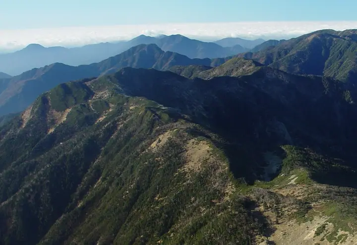
Chausu-dake (2,604 m) rises on the southern main ridge of the Akaishi Range (Southern Alps), straddling Iida City in Nagano and Aoi Ward of Shizuoka City. It is included in the 300 Famous Mountains of Japan and lies within the special protection and special zones of Minami Alps National Park. The summit marks the local treeline, with dwarf pine, Erman's birch and resident rock ptarmigan; a distinctive alpine flower field with patterned ground lies about 1.2 km to the north. The shortest approach starts from the Hatanagi suspension bridge on the Shizuoka side and climbs via the Chausu Hut (2,400 m), making this peak a common gateway to Kamikouchi-dake and Hijiri-dake on the southern Akaishi traverse.
Mt. Chausudake at a glance
- Weather: The most settled day in the next 7 days is Wed, November 4: cloudy, gusts up to 9 m/s. Fri, Nov 6, Sat, Nov 7: strong wind (gusts up to 17 m/s).
Mt. Chausudake weather (hourly, 14 days)
Sunrise today 06:10, sunset 16:52
| Tue, 11/3 | Wed, 11/4 | Thu, 11/5 | Fri, 11/6 | Sat, 11/7 | Sun, 11/8 | Mon, 11/9 | Tue, 11/10 | Wed, 11/11 | Thu, 11/12 | Fri, 11/13 | Sat, 11/14 | Sun, 11/15 | Mon, 11/16 | Tue, 11/17 | |||||||||||||||||||||||||||||||||||||||||||||||||||||||||||||||||||||||
|---|---|---|---|---|---|---|---|---|---|---|---|---|---|---|---|---|---|---|---|---|---|---|---|---|---|---|---|---|---|---|---|---|---|---|---|---|---|---|---|---|---|---|---|---|---|---|---|---|---|---|---|---|---|---|---|---|---|---|---|---|---|---|---|---|---|---|---|---|---|---|---|---|---|---|---|---|---|---|---|---|---|---|---|---|---|
| Japan time | 15 | 17 | 19 | 21 | 23 | 1 | 3 | 5 | 7 | 9 | 11 | 13 | 15 | 18 | 21 | 0 | 3 | 6 | 9 | 12 | 15 | 18 | 21 | 0 | 3 | 6 | 9 | 12 | 15 | 18 | 21 | 0 | 3 | 6 | 9 | 12 | 15 | 18 | 21 | 0 | 3 | 6 | 9 | 12 | 15 | 18 | 21 | 0 | 3 | 6 | 9 | 15 | 21 | 3 | 9 | 15 | 21 | 3 | 9 | 15 | 21 | 3 | 9 | 15 | 21 | 3 | 9 | 15 | 21 | 3 | 9 | 15 | 21 | 3 | 9 | 15 | 21 | 3 | 9 | 15 | 21 | 3 | 9 | 15 | |
 |   |   | | |   | | |   |   | |   | | | | | | |   | | |   | |  |   | | | | | | | | | | | | | | | | | |   | | | | | | | | | | | | | | |   | | |   |  | |   | | | | | | | | | | | | | | | | | | | | | ||
| Temperature | °C | 3° | -1° | -2° | -4° | -5° | -4° | -4° | -3° | -2° | 1° | 4° | 2° | 2° | 0° | 0° | 0° | 1° | 2° | 5° | 8° | 4° | 2° | 0° | -1° | 0° | 1° | 4° | 7° | 5° | -3° | -4° | -6° | -8° | -10° | -3° | 0° | -1° | -8° | -9° | -9° | -8° | -7° | 1° | 3° | 1° | -3° | -3° | -3° | -3° | -5° | 0° | 1° | -6° | -8° | -2° | -1° | -5° | -8° | -4° | 0° | -8° | -8° | -3° | -1° | -8° | -8° | 0° | 1° | -7° | -6° | -1° | 1° | -7° | -5° | 1° | 1° | 0° | 0° | 4° | 5° | -3° | -3° | -3° | -1° |
| Precipitation | mm | 0.2 | 0.5 | 0.3 | 1.1 | 0.1 | 8 | 12 | 6 | 0.6 | 0.2 | 1.3 | 0.1 | 0.4 | 0.8 | 0.2 | 0.1 | 1.0 | 23 | 27 | 2.3 | 0.4 | 3.2 | 0.2 | 0.5 | ||||||||||||||||||||||||||||||||||||||||||||||||||||||||||||
| New snow | cm | 0.1 | |||||||||||||||||||||||||||||||||||||||||||||||||||||||||||||||||||||||||||||||||||
| Snow depth | cm | 0 | 0 | 0 | 0 | 0 | 0 | 0 | 0 | 0 | 0 | 0 | 0 | 0 | 0 | 0 | 0 | 0 | 0 | 0 | 0 | 0 | 0 | 0 | 0 | 0 | 0 | 0 | 0 | 0 | 0 | 0 | 0 | 0 | 0 | 0 | 0 | 0 | 0 | 0 | 0 | 0 | 0 | 0 | 0 | 0 | 0 | 0 | 0 | 0 | 0 | 0 | 0 | 0 | 0 | 0 | 0 | 0 | 0 | 0 | 0 | 0 | 0 | 0 | 0 | 0 | 0 | 0 | 0 | 0 | 0 | 0 | 0 | 0 | 0 | 0 | 0 | 0 | 0 | 0 | 0 | 0 | 0 | 0 | 0 |
| Wind | m/s | 2 | 1 | 1 | 1 | 1 | 1 | 1 | 0 | 0 | 1 | 2 | 2 | 1 | 2 | 2 | 2 | 1 | 0 | 1 | 1 | 1 | 1 | 1 | 2 | 2 | 3 | 3 | 3 | 3 | 3 | 3 | 3 | 3 | 3 | 3 | 3 | 2 | 2 | 1 | 1 | 1 | 1 | 0 | 2 | 2 | 1 | 1 | 1 | 1 | 2 | 2 | 2 | 1 | 1 | 1 | 3 | 3 | 6 | 2 | 0 | 0 | 1 | 2 | 2 | 1 | 2 | 1 | 1 | 0 | 1 | 1 | 1 | 2 | 1 | 2 | 2 | 1 | 1 | 3 | 3 | 0 | 1 | 1 | 2 |
| Wind gusts | m/s | 11 | 11 | 8 | 6 | 6 | 6 | 6 | 6 | 5 | 6 | 9 | 9 | 7 | 8 | 9 | 12 | 13 | 11 | 8 | 8 | 11 | 14 | 9 | 11 | 13 | 14 | 14 | 14 | 15 | 15 | 15 | 16 | 17 | 17 | 17 | 16 | 15 | 12 | 11 | 10 | 10 | 10 | 9 | 9 | 10 | 8 | 7 | 9 | 9 | 9 | 11 | 14 | 9 | 8 | 9 | 15 | 13 | 25 | 26 | 16 | 7 | 7 | 10 | 12 | 10 | 9 | 10 | 10 | 7 | 6 | 6 | 9 | 8 | 8 | 10 | 14 | 14 | 15 | 15 | 16 | 12 | 7 | 6 | 9 |
| Wind dir. | ↓ | ↓ | ↓ | ↓ | ↓ | ↓ | ↓ | ↓ | ↓ | ↓ | ↓ | ↓ | ↓ | ↓ | ↓ | ↓ | ↓ | ↓ | ↓ | ↓ | ↓ | ↓ | ↓ | ↓ | ↓ | ↓ | ↓ | ↓ | ↓ | ↓ | ↓ | ↓ | ↓ | ↓ | ↓ | ↓ | ↓ | ↓ | ↓ | ↓ | ↓ | ↓ | ↓ | ↓ | ↓ | ↓ | ↓ | ↓ | ↓ | ↓ | ↓ | ↓ | ↓ | ↓ | ↓ | ↓ | ↓ | ↓ | ↓ | ↓ | ↓ | ↓ | ↓ | ↓ | ↓ | ↓ | ↓ | ↓ | ↓ | ↓ | ↓ | ↓ | ↓ | ↓ | ↓ | ↓ | ↓ | ↓ | ↓ | ↓ | ↓ | ↓ | ↓ | ↓ | |
Huts, campsites and lodging near Mt. Chausudake
Mountain huts
- Chausu Hut 2026: open July 11–September 23 · reservation required
- Yokokubozawa Lodge unstaffed
- Usokkozawa Lodge unstaffed
- Hijiridaira Lodge 2026: open July 11–September 23 · reservation required
- Seiko Goya 2026: open April 24–October 12 · reservation required · sleeps 18
Campsites
- 聖平露営地
- Mendaira Camp
Lists that include Mt. Chausudake
Japan's 300 Famous Mountains · Shinshu 100 Famous Mountains · 100 Mountains of Shizuoka · Elevations of 1003 Mountains of Japan
Mt. Chausudake facts
- Elevation
- 2,604 m
- Location
- Iida, Nagano / Shizuoka, Shizuoka
35.369140, 138.140395 - National Park
- 南アルプス国立公園
- Website
- minamialps-shizuokaken.jp
- Trail Map
- www.city.shizuoka.lg.jp (PDF)
- Wikipedia
- ja.wikipedia.org