
Mount Kamikōchi
上河内岳
Shizuoka, Shizuoka / Iida, Nagano · Elevation 2,803 m
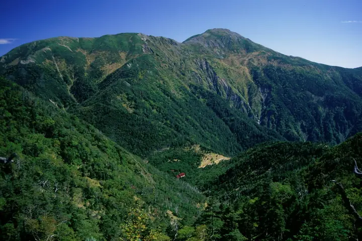
Mount Kamikōchi is a 2,803 m peak in Aoi Ward, Shizuoka City, rising as a sharp tower between Mounts Hijiri and Chausu in the southern Akaishi (South Japanese) Alps. Set within Minami-Alps National Park and the South Alps UNESCO Biosphere Reserve, it is listed in the Nihon Nihyaku Meizan, the Nihon Hyaku Kōzan, and the Shizuoka Hyakuzan. The summit's wind-swept alpine meadow and patterned ground (kikkō-jō-do) are textbook examples of periglacial landforms in the southern range. The summit commands a 360° panorama spanning Hijiri, Akaishi, Tekkari, Fuji, and the Central Alps as far as Utsugi and Kiso-Komagatake. A standard Shizuoka-side approach starts at Numadaira beyond Hatanagi Daiichi Dam, proceeds on foot to the Hatanagi suspension bridge, climbs via Yokokubosawa-goya to Chausu-goya, and then follows the ridge north to the summit. The mountain can also be combined with Mount Hijiri on a traverse via Hijiri-daira.
Mount Kamikōchi at a glance
- Weather: The most settled day in the next 7 days is Wed, November 4: cloudy, gusts up to 9 m/s. Fri, Nov 6, Sat, Nov 7: strong wind (gusts up to 17 m/s).
Mount Kamikōchi weather (hourly, 14 days)
Sunrise today 06:10, sunset 16:52
| Tue, 11/3 | Wed, 11/4 | Thu, 11/5 | Fri, 11/6 | Sat, 11/7 | Sun, 11/8 | Mon, 11/9 | Tue, 11/10 | Wed, 11/11 | Thu, 11/12 | Fri, 11/13 | Sat, 11/14 | Sun, 11/15 | Mon, 11/16 | Tue, 11/17 | |||||||||||||||||||||||||||||||||||||||||||||||||||||||||||||||||||||||
|---|---|---|---|---|---|---|---|---|---|---|---|---|---|---|---|---|---|---|---|---|---|---|---|---|---|---|---|---|---|---|---|---|---|---|---|---|---|---|---|---|---|---|---|---|---|---|---|---|---|---|---|---|---|---|---|---|---|---|---|---|---|---|---|---|---|---|---|---|---|---|---|---|---|---|---|---|---|---|---|---|---|---|---|---|---|
| Japan time | 15 | 17 | 19 | 21 | 23 | 1 | 3 | 5 | 7 | 9 | 11 | 13 | 15 | 18 | 21 | 0 | 3 | 6 | 9 | 12 | 15 | 18 | 21 | 0 | 3 | 6 | 9 | 12 | 15 | 18 | 21 | 0 | 3 | 6 | 9 | 12 | 15 | 18 | 21 | 0 | 3 | 6 | 9 | 12 | 15 | 18 | 21 | 0 | 3 | 6 | 9 | 15 | 21 | 3 | 9 | 15 | 21 | 3 | 9 | 15 | 21 | 3 | 9 | 15 | 21 | 3 | 9 | 15 | 21 | 3 | 9 | 15 | 21 | 3 | 9 | 15 | 21 | 3 | 9 | 15 | 21 | 3 | 9 | 15 | |
 |   |   | | |   | | |   |   | |   | | | | | | |   | | |   | |  |   | | | | | | | | | | | | | | | | | |   | | | | | | | | | | | | | | |   | | |   |  | |   | | | | | | | | | | | | | | | | | | | | | ||
| Temperature | °C | 2° | -3° | -4° | -5° | -6° | -6° | -6° | -4° | -3° | 0° | 3° | 1° | 1° | -1° | -1° | -1° | -1° | 1° | 4° | 7° | 3° | 1° | -1° | -2° | -1° | -1° | 2° | 6° | 3° | -4° | -5° | -7° | -9° | -11° | -4° | -1° | -2° | -9° | -11° | -10° | -10° | -9° | -1° | 2° | 0° | -4° | -5° | -5° | -5° | -6° | -1° | 0° | -7° | -9° | -3° | -2° | -6° | -10° | -5° | -1° | -9° | -9° | -4° | -2° | -9° | -9° | -2° | 0° | -8° | -8° | -2° | -1° | -8° | -6° | 0° | 0° | -1° | -1° | 3° | 4° | -4° | -4° | -4° | -2° |
| Precipitation | mm | 0.2 | 0.5 | 0.3 | 1.1 | 0.1 | 8 | 12 | 6 | 0.6 | 0.2 | 1.3 | 0.1 | 0.4 | 0.8 | 0.2 | 0.1 | 1.0 | 23 | 27 | 2.3 | 0.4 | 3.2 | 0.2 | 0.5 | ||||||||||||||||||||||||||||||||||||||||||||||||||||||||||||
| New snow | cm | 0.1 | |||||||||||||||||||||||||||||||||||||||||||||||||||||||||||||||||||||||||||||||||||
| Snow depth | cm | 0 | 0 | 0 | 0 | 0 | 0 | 0 | 0 | 0 | 0 | 0 | 0 | 0 | 0 | 0 | 0 | 0 | 0 | 0 | 0 | 0 | 0 | 0 | 0 | 0 | 0 | 0 | 0 | 0 | 0 | 0 | 0 | 0 | 0 | 0 | 0 | 0 | 0 | 0 | 0 | 0 | 0 | 0 | 0 | 0 | 0 | 0 | 0 | 0 | 0 | 0 | 0 | 0 | 0 | 0 | 0 | 0 | 0 | 0 | 0 | 0 | 0 | 0 | 0 | 0 | 0 | 0 | 0 | 0 | 0 | 0 | 0 | 0 | 0 | 0 | 0 | 0 | 0 | 0 | 0 | 0 | 0 | 0 | 0 |
| Wind | m/s | 2 | 1 | 1 | 1 | 1 | 1 | 1 | 0 | 0 | 1 | 2 | 2 | 1 | 2 | 2 | 2 | 1 | 0 | 1 | 1 | 1 | 1 | 1 | 2 | 2 | 3 | 3 | 3 | 3 | 3 | 3 | 3 | 3 | 3 | 3 | 3 | 2 | 2 | 1 | 1 | 1 | 1 | 0 | 2 | 2 | 1 | 1 | 1 | 1 | 2 | 2 | 2 | 1 | 1 | 1 | 3 | 3 | 6 | 2 | 0 | 0 | 1 | 2 | 2 | 1 | 2 | 1 | 1 | 0 | 1 | 1 | 1 | 2 | 1 | 2 | 2 | 1 | 1 | 3 | 3 | 0 | 1 | 1 | 2 |
| Wind gusts | m/s | 11 | 11 | 8 | 6 | 6 | 6 | 6 | 6 | 5 | 6 | 9 | 9 | 7 | 8 | 9 | 12 | 13 | 11 | 8 | 8 | 11 | 14 | 9 | 11 | 13 | 14 | 14 | 14 | 15 | 15 | 15 | 16 | 17 | 17 | 17 | 16 | 15 | 12 | 11 | 10 | 10 | 10 | 9 | 9 | 10 | 8 | 7 | 9 | 9 | 9 | 11 | 14 | 9 | 8 | 9 | 15 | 13 | 25 | 26 | 16 | 7 | 7 | 10 | 12 | 10 | 9 | 10 | 10 | 7 | 6 | 6 | 9 | 8 | 8 | 10 | 14 | 14 | 15 | 15 | 16 | 12 | 7 | 6 | 9 |
| Wind dir. | ↓ | ↓ | ↓ | ↓ | ↓ | ↓ | ↓ | ↓ | ↓ | ↓ | ↓ | ↓ | ↓ | ↓ | ↓ | ↓ | ↓ | ↓ | ↓ | ↓ | ↓ | ↓ | ↓ | ↓ | ↓ | ↓ | ↓ | ↓ | ↓ | ↓ | ↓ | ↓ | ↓ | ↓ | ↓ | ↓ | ↓ | ↓ | ↓ | ↓ | ↓ | ↓ | ↓ | ↓ | ↓ | ↓ | ↓ | ↓ | ↓ | ↓ | ↓ | ↓ | ↓ | ↓ | ↓ | ↓ | ↓ | ↓ | ↓ | ↓ | ↓ | ↓ | ↓ | ↓ | ↓ | ↓ | ↓ | ↓ | ↓ | ↓ | ↓ | ↓ | ↓ | ↓ | ↓ | ↓ | ↓ | ↓ | ↓ | ↓ | ↓ | ↓ | ↓ | ↓ | |
Huts, campsites and lodging near Mount Kamikōchi
Mountain huts
- Chausu Hut 2026: open July 11–September 23 · reservation required
- Hijiridaira Lodge 2026: open July 11–September 23 · reservation required
- Yokokubozawa Lodge unstaffed
- Usokkozawa Lodge unstaffed
Campsites
- 聖平露営地
Lists that include Mount Kamikōchi
Japan 200 Famous Mountains · Japan's 300 Famous Mountains · Japan's 100 Highest Mountains · 100 Mountains of Shizuoka · Elevations of 1003 Mountains of Japan · 1000 Mountains of Japan
Mount Kamikōchi facts
- Elevation
- 2,803 m
- Location
- Shizuoka, Shizuoka / Iida, Nagano
35.389623, 138.152808 - National Park
- 南アルプス国立公園
- Website
- www.city.shizuoka.lg.jp
- Trail Map
- www.pref.shizuoka.jp
- Access Information
- www.city.shizuoka.lg.jp
- Wikipedia
- ja.wikipedia.org