
Mount Tsurugi
剣山
Naka-chō, Tokushima / Miyoshi, Tokushima · Elevation 1,955 m
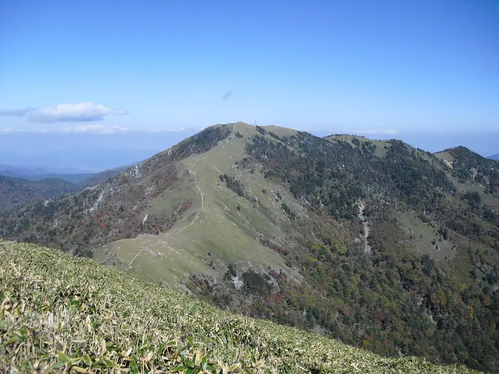
Mount Tsurugi is a 1,955 m peak on the boundary between Miyoshi, Mima, and Naka in Tokushima Prefecture, the highest summit in Tokushima and the second-highest in Shikoku after Mount Ishizuchi. Listed in Fukada Kyūya's Hyakumeizan, the Hana-no-Hyakumeizan, and the Ittō-Sankakuten Hyakumeizan, it forms the centre of Tsurugisan Quasi-National Park. Long venerated by Shugendō practitioners, the summit holds the Tsurugisan-Hongū Hōzōseki Shrine, and the mountain name ("sword") is said to derive from a tradition that a sacred sword was buried here. Together with neighboring Mount Jirōgyū it is also called Tarōgyū, and its broad summit plateau is covered in bamboo grass, making for an easy ridge walk. The standard route ascends from Mi-no-Koshi by the Tsurugisan tourism chairlift to Nishijima and takes about 40 minutes more on foot to the summit; the lift typically operates from mid-April through late November.
Mount Tsurugi at a glance
- Weather: The most settled day in the next 7 days is Sun, November 8: clear, gusts up to 7 m/s. Fri, Nov 6, Sat, Nov 7: strong wind (gusts up to 16 m/s).
- Route: The shortest is Tokushima Return from the Base of Tsurugi Worship past the Katanakake Pine and Hozoseki Shrine to the Boardwalk Summit: about 3 h 33 min, 5.4 km, about 570 m of climbing.
Mount Tsurugi weather (hourly, 14 days)
Sunrise today 06:24, sunset 17:11
| Tue, 11/3 | Wed, 11/4 | Thu, 11/5 | Fri, 11/6 | Sat, 11/7 | Sun, 11/8 | Mon, 11/9 | Tue, 11/10 | Wed, 11/11 | Thu, 11/12 | Fri, 11/13 | Sat, 11/14 | Sun, 11/15 | Mon, 11/16 | Tue, 11/17 | |||||||||||||||||||||||||||||||||||||||||||||||||||||||||||||||||||||||
|---|---|---|---|---|---|---|---|---|---|---|---|---|---|---|---|---|---|---|---|---|---|---|---|---|---|---|---|---|---|---|---|---|---|---|---|---|---|---|---|---|---|---|---|---|---|---|---|---|---|---|---|---|---|---|---|---|---|---|---|---|---|---|---|---|---|---|---|---|---|---|---|---|---|---|---|---|---|---|---|---|---|---|---|---|---|
| Japan time | 15 | 17 | 19 | 21 | 23 | 1 | 3 | 5 | 7 | 9 | 11 | 13 | 15 | 18 | 21 | 0 | 3 | 6 | 9 | 12 | 15 | 18 | 21 | 0 | 3 | 6 | 9 | 12 | 15 | 18 | 21 | 0 | 3 | 6 | 9 | 12 | 15 | 18 | 21 | 0 | 3 | 6 | 9 | 12 | 15 | 18 | 21 | 0 | 3 | 6 | 9 | 15 | 21 | 3 | 9 | 15 | 21 | 3 | 9 | 15 | 21 | 3 | 9 | 15 | 21 | 3 | 9 | 15 | 21 | 3 | 9 | 15 | 21 | 3 | 9 | 15 | 21 | 3 | 9 | 15 | 21 | 3 | 9 | 15 | |
 |   |   |   |   | | | |   | |   | | | |   | | | |   | | | | | | | |   | | |  | | | | | | | | | | | | | | | | | | | | | | | | | | | | | | | | | | | |   | | | | | | | | | | | | | | | | | | | ||
| Temperature | °C | 7° | 3° | 2° | 2° | 2° | 2° | 2° | 1° | 1° | 3° | 7° | 8° | 8° | 5° | 5° | 6° | 6° | 7° | 9° | 12° | 13° | 8° | 8° | 8° | 8° | 4° | 5° | 8° | 6° | 2° | 0° | -2° | -2° | -3° | -1° | 1° | 2° | -3° | -4° | -5° | -5° | -5° | 3° | 6° | 5° | 0° | 1° | 0° | 0° | 1° | 3° | 5° | -1° | -2° | 1° | 4° | -2° | -4° | -3° | 0° | -4° | -6° | 2° | 5° | -3° | -2° | 1° | 2° | -4° | -5° | 4° | 8° | -1° | 0° | 7° | 7° | 7° | 5° | 6° | 6° | 2° | -2° | 1° | 5° |
| Precipitation | mm | 0.2 | 1.9 | 0.5 | 0.8 | 0.2 | 0.4 | 0.8 | 0.2 | 0.8 | 0.2 | 0.2 | 0.2 | 0.4 | 0.5 | 7 | 0.4 | 0.9 | 1.2 | 2.7 | 0.6 | ||||||||||||||||||||||||||||||||||||||||||||||||||||||||||||||||
| New snow | cm | ||||||||||||||||||||||||||||||||||||||||||||||||||||||||||||||||||||||||||||||||||||
| Snow depth | cm | 0 | 0 | 0 | 0 | 0 | 0 | 0 | 0 | 0 | 0 | 0 | 0 | 0 | 0 | 0 | 0 | 0 | 0 | 0 | 0 | 0 | 0 | 0 | 0 | 0 | 0 | 0 | 0 | 0 | 0 | 0 | 0 | 0 | 0 | 0 | 0 | 0 | 0 | 0 | 0 | 0 | 0 | 0 | 0 | 0 | 0 | 0 | 0 | 0 | 0 | 0 | 0 | 0 | 0 | 0 | 0 | 0 | 0 | 0 | 0 | 0 | 0 | 0 | 0 | 0 | 0 | 0 | 0 | 0 | 0 | 0 | 0 | 0 | 0 | 0 | 0 | 0 | 0 | 0 | 0 | 0 | 0 | 0 | 0 |
| Wind | m/s | 3 | 1 | 1 | 1 | 1 | 1 | 2 | 2 | 2 | 2 | 2 | 1 | 1 | 1 | 1 | 2 | 1 | 0 | 1 | 1 | 2 | 3 | 3 | 3 | 4 | 4 | 4 | 5 | 5 | 3 | 4 | 4 | 4 | 4 | 4 | 4 | 4 | 2 | 1 | 1 | 1 | 0 | 2 | 2 | 2 | 1 | 0 | 1 | 2 | 1 | 2 | 3 | 1 | 1 | 1 | 4 | 4 | 6 | 5 | 5 | 1 | 0 | 1 | 2 | 1 | 2 | 4 | 4 | 0 | 0 | 1 | 1 | 1 | 2 | 4 | 4 | 4 | 1 | 4 | 5 | 3 | 1 | 1 | 2 |
| Wind gusts | m/s | 9 | 9 | 5 | 6 | 4 | 5 | 6 | 6 | 6 | 6 | 6 | 6 | 5 | 6 | 6 | 7 | 9 | 4 | 5 | 6 | 9 | 10 | 13 | 13 | 13 | 15 | 15 | 16 | 15 | 15 | 16 | 17 | 17 | 18 | 16 | 16 | 15 | 13 | 9 | 7 | 5 | 5 | 7 | 7 | 7 | 7 | 3 | 6 | 8 | 7 | 7 | 10 | 10 | 5 | 6 | 12 | 15 | 19 | 19 | 17 | 14 | 5 | 5 | 8 | 6 | 10 | 12 | 13 | 12 | 4 | 4 | 6 | 6 | 7 | 13 | 16 | 18 | 14 | 13 | 16 | 15 | 10 | 6 | 8 |
| Wind dir. | ↓ | ↓ | ↓ | ↓ | ↓ | ↓ | ↓ | ↓ | ↓ | ↓ | ↓ | ↓ | ↓ | ↓ | ↓ | ↓ | ↓ | ↓ | ↓ | ↓ | ↓ | ↓ | ↓ | ↓ | ↓ | ↓ | ↓ | ↓ | ↓ | ↓ | ↓ | ↓ | ↓ | ↓ | ↓ | ↓ | ↓ | ↓ | ↓ | ↓ | ↓ | ↓ | ↓ | ↓ | ↓ | ↓ | ↓ | ↓ | ↓ | ↓ | ↓ | ↓ | ↓ | ↓ | ↓ | ↓ | ↓ | ↓ | ↓ | ↓ | ↓ | ↓ | ↓ | ↓ | ↓ | ↓ | ↓ | ↓ | ↓ | ↓ | ↓ | ↓ | ↓ | ↓ | ↓ | ↓ | ↓ | ↓ | ↓ | ↓ | ↓ | ↓ | ↓ | ↓ | |
Mount Tsurugi hiking routes
- Tokushima Return from the Base of Tsurugi Worship past the Katanakake Pine and Hozoseki Shrine to the Boardwalk Summit 5.4 km · Ascent 569 m 見ノ越 (Bus stop), Minokoshi (Aerialway station), 見ノ越駅 (Aerialway station), 見ノ越第一駐車場 (parking)
- Mount Tsurugi Circuit from Minokoshi via Otsurugi Shrine 5.7 km · Ascent 569 m 見ノ越 (Bus stop), Minokoshi (Aerialway station), 見ノ越駅 (Aerialway station), 見ノ越第一駐車場 (parking)
- Mount Tsurugi and Mount Jirogyu Circuit from Minokoshi 8.8 km · Ascent 815 m 見ノ越 (Bus stop), Minokoshi (Aerialway station), 見ノ越駅 (Aerialway station), 見ノ越第一駐車場 (parking)
- Mount Tsurugi, Jirogyu, and Miune Traverse from Minokoshi to Nagoro 21.0 km · Ascent 1,706 m 見ノ越 (Bus stop), Minokoshi (Aerialway station), 見ノ越駅 (Aerialway station), 見ノ越第一駐車場 (parking) → 三嶺登山口, 名頃バス停 (Bus stop), 三嶺登山口 Miune Trailhead
Hiking times are estimates calculated from the terrain.
Huts, campsites and lodging near Mount Tsurugi
Mountain huts
- 雲海荘 2026: open April 28–November 23 · reservation required · sleeps 70
- Tsurugi Mountain Summit Hut 2026: open April 28–November 23
- 剣山一の森ヒュッテ
Campsites
- 奥祖谷二重かずら橋キャンプ場
Lodging
- 霧の峰
- 民宿 平家の宿
- 剣神社簡易宿泊所
- 民宿まつうら
- ラ・フォーレつるぎ山
Lists that include Mount Tsurugi
100 Famous Japanese Mountains · Japan 200 Famous Mountains · Japan's 300 Famous Mountains · 100 Famous Mountains of Flowers · 100 Famous Mountains with First-order Triangulation Points · New Japan 100 Famous Mountains · Highest Peaks by Prefecture · 100 Famous Hot Spring Mountains · Shikoku 100 Famous Mountains · Elevations of 1003 Mountains of Japan · 1000 Mountains of Japan
Mount Tsurugi facts
- Also known as
- 太郎笈
- Elevation
- 1,955 m
- Location
- Naka-chō, Tokushima / Miyoshi, Tokushima
33.853577, 134.094288 - National Park
- 剣山国定公園
- Website
- nishi-awa.jp
- Trail Map
- nishi-awa.jp (PDF)
- Wikipedia
- ja.wikipedia.org