
Tonomaru
塔丸
Miyoshi, Tokushima · Elevation 1,713 m
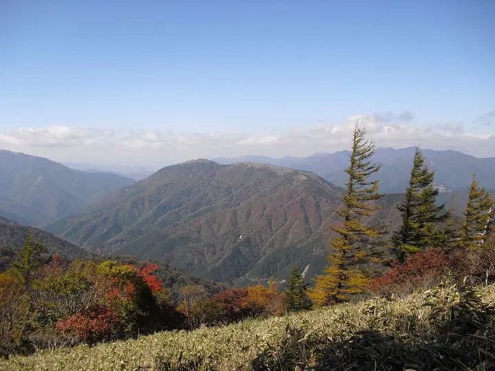
A gentle ridge of dwarf bamboo grass with scattered rock outcrops leads to the summit. The approach starts near Meotoike ponds. Across the Iya River valley, the summit offers views of Tsurugisan, Jirogyu and Miune.
Tonomaru at a glance
- Weather: The most settled day in the next 7 days is Sun, November 8: clear, gusts up to 7 m/s. Fri, Nov 6, Sat, Nov 7: strong wind (gusts up to 16 m/s).
- Route: The shortest is Mount Tonomaru Return from the Tonomaru Trailhead: about 4 h 10 min, 7.4 km, about 420 m of climbing.
Tonomaru weather (hourly, 14 days)
Sunrise today 06:24, sunset 17:11
| Tue, 11/3 | Wed, 11/4 | Thu, 11/5 | Fri, 11/6 | Sat, 11/7 | Sun, 11/8 | Mon, 11/9 | Tue, 11/10 | Wed, 11/11 | Thu, 11/12 | Fri, 11/13 | Sat, 11/14 | Sun, 11/15 | Mon, 11/16 | Tue, 11/17 | |||||||||||||||||||||||||||||||||||||||||||||||||||||||||||||||||||||||
|---|---|---|---|---|---|---|---|---|---|---|---|---|---|---|---|---|---|---|---|---|---|---|---|---|---|---|---|---|---|---|---|---|---|---|---|---|---|---|---|---|---|---|---|---|---|---|---|---|---|---|---|---|---|---|---|---|---|---|---|---|---|---|---|---|---|---|---|---|---|---|---|---|---|---|---|---|---|---|---|---|---|---|---|---|---|
| Japan time | 15 | 17 | 19 | 21 | 23 | 1 | 3 | 5 | 7 | 9 | 11 | 13 | 15 | 18 | 21 | 0 | 3 | 6 | 9 | 12 | 15 | 18 | 21 | 0 | 3 | 6 | 9 | 12 | 15 | 18 | 21 | 0 | 3 | 6 | 9 | 12 | 15 | 18 | 21 | 0 | 3 | 6 | 9 | 12 | 15 | 18 | 21 | 0 | 3 | 6 | 9 | 15 | 21 | 3 | 9 | 15 | 21 | 3 | 9 | 15 | 21 | 3 | 9 | 15 | 21 | 3 | 9 | 15 | 21 | 3 | 9 | 15 | 21 | 3 | 9 | 15 | 21 | 3 | 9 | 15 | 21 | 3 | 9 | 15 | |
 |   |   |   |   | | | |   | |   | | | |   | | | |   | | | | | | | |   | | |  | | | | | | | | | | | | | | | | | | | | | | | | | | | | | | | | | | | |   | | | | | | | | | | | | | | | | | | | ||
| Temperature | °C | 8° | 5° | 4° | 3° | 3° | 3° | 3° | 3° | 3° | 5° | 9° | 9° | 10° | 7° | 7° | 7° | 8° | 8° | 10° | 14° | 14° | 9° | 10° | 10° | 9° | 6° | 6° | 9° | 8° | 3° | 1° | 0° | -1° | -1° | 0° | 3° | 3° | -2° | -2° | -3° | -4° | -3° | 5° | 8° | 6° | 2° | 2° | 1° | 2° | 2° | 5° | 6° | 1° | -1° | 3° | 5° | -1° | -2° | -1° | 2° | -3° | -5° | 3° | 7° | -1° | 0° | 2° | 3° | -2° | -3° | 5° | 10° | 1° | 1° | 8° | 8° | 8° | 7° | 7° | 8° | 3° | -1° | 2° | 7° |
| Precipitation | mm | 0.2 | 1.9 | 0.5 | 0.8 | 0.2 | 0.4 | 0.8 | 0.2 | 0.8 | 0.2 | 0.2 | 0.2 | 0.4 | 0.5 | 7 | 0.4 | 0.9 | 1.2 | 2.7 | 0.6 | ||||||||||||||||||||||||||||||||||||||||||||||||||||||||||||||||
| New snow | cm | ||||||||||||||||||||||||||||||||||||||||||||||||||||||||||||||||||||||||||||||||||||
| Snow depth | cm | 0 | 0 | 0 | 0 | 0 | 0 | 0 | 0 | 0 | 0 | 0 | 0 | 0 | 0 | 0 | 0 | 0 | 0 | 0 | 0 | 0 | 0 | 0 | 0 | 0 | 0 | 0 | 0 | 0 | 0 | 0 | 0 | 0 | 0 | 0 | 0 | 0 | 0 | 0 | 0 | 0 | 0 | 0 | 0 | 0 | 0 | 0 | 0 | 0 | 0 | 0 | 0 | 0 | 0 | 0 | 0 | 0 | 0 | 0 | 0 | 0 | 0 | 0 | 0 | 0 | 0 | 0 | 0 | 0 | 0 | 0 | 0 | 0 | 0 | 0 | 0 | 0 | 0 | 0 | 0 | 0 | 0 | 0 | 0 |
| Wind | m/s | 3 | 1 | 1 | 1 | 1 | 1 | 2 | 2 | 2 | 2 | 2 | 1 | 1 | 1 | 1 | 2 | 1 | 0 | 1 | 1 | 2 | 3 | 3 | 3 | 4 | 4 | 4 | 5 | 5 | 3 | 4 | 4 | 4 | 4 | 4 | 4 | 4 | 2 | 1 | 1 | 1 | 0 | 2 | 2 | 2 | 1 | 0 | 1 | 2 | 1 | 2 | 3 | 1 | 1 | 1 | 4 | 4 | 6 | 5 | 5 | 1 | 0 | 1 | 2 | 1 | 2 | 4 | 4 | 0 | 0 | 1 | 1 | 1 | 2 | 4 | 4 | 4 | 1 | 4 | 5 | 3 | 1 | 1 | 2 |
| Wind gusts | m/s | 9 | 9 | 5 | 6 | 4 | 5 | 6 | 6 | 6 | 6 | 6 | 6 | 5 | 6 | 6 | 7 | 9 | 4 | 5 | 6 | 9 | 10 | 13 | 13 | 13 | 15 | 15 | 16 | 15 | 15 | 16 | 17 | 17 | 18 | 16 | 16 | 15 | 13 | 9 | 7 | 5 | 5 | 7 | 7 | 7 | 7 | 3 | 6 | 8 | 7 | 7 | 10 | 10 | 5 | 6 | 12 | 15 | 19 | 19 | 17 | 14 | 5 | 5 | 8 | 6 | 10 | 12 | 13 | 12 | 4 | 4 | 6 | 6 | 7 | 13 | 16 | 18 | 14 | 13 | 16 | 15 | 10 | 6 | 8 |
| Wind dir. | ↓ | ↓ | ↓ | ↓ | ↓ | ↓ | ↓ | ↓ | ↓ | ↓ | ↓ | ↓ | ↓ | ↓ | ↓ | ↓ | ↓ | ↓ | ↓ | ↓ | ↓ | ↓ | ↓ | ↓ | ↓ | ↓ | ↓ | ↓ | ↓ | ↓ | ↓ | ↓ | ↓ | ↓ | ↓ | ↓ | ↓ | ↓ | ↓ | ↓ | ↓ | ↓ | ↓ | ↓ | ↓ | ↓ | ↓ | ↓ | ↓ | ↓ | ↓ | ↓ | ↓ | ↓ | ↓ | ↓ | ↓ | ↓ | ↓ | ↓ | ↓ | ↓ | ↓ | ↓ | ↓ | ↓ | ↓ | ↓ | ↓ | ↓ | ↓ | ↓ | ↓ | ↓ | ↓ | ↓ | ↓ | ↓ | ↓ | ↓ | ↓ | ↓ | ↓ | ↓ | |
Tonomaru hiking routes
Hiking times are estimates calculated from the terrain.
Huts, campsites and lodging near Tonomaru
Mountain huts
- 旧造林小屋
Campsites
- 奥祖谷二重かずら橋キャンプ場
Lodging
- 松浦商店/民宿松浦
- ラ・フォーレつるぎ山
- 民宿まつうら
- 霧の峰
- 民宿 平家の宿
Tonomaru facts
- Elevation
- 1,713 m
- Location
- Miyoshi, Tokushima
33.866932, 134.039254 - Website
- www.rinya.maff.go.jp
- Wikipedia
- ja.wikipedia.org