
Mount Jirogyu
次郎笈
Naka-chō, Tokushima / Miyoshi, Tokushima · Elevation 1,929 m
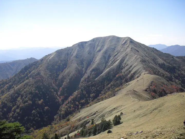
Mount Jirogyu (1,929 m) rises on the border of Miyoshi City and Naka Town in Tokushima Prefecture, forming the southwestern twin of Mount Tsurugi (1,955 m), the second-highest peak in Shikoku. Mount Tsurugi was historically known as Tarogyu (Elder Brother), giving its companion the name Jirogyu (Younger Brother). The mountain lies within Tsurugisan Quasi-National Park and the Tsurugisan Nature Recreation Forest, and is a popular Shikoku 100 Mountain with sweeping ridge-walks and panoramic views.
Mount Jirogyu at a glance
- Weather: The most settled day in the next 7 days is Sun, November 8: clear, gusts up to 7 m/s. Fri, Nov 6, Sat, Nov 7: strong wind (gusts up to 16 m/s).
- Route: The shortest is Mount Tsurugi and Mount Jirogyu Circuit from Minokoshi: about 5 h 34 min, 8.8 km, about 820 m of climbing.
Mount Jirogyu weather (hourly, 14 days)
Sunrise today 06:24, sunset 17:11
| Tue, 11/3 | Wed, 11/4 | Thu, 11/5 | Fri, 11/6 | Sat, 11/7 | Sun, 11/8 | Mon, 11/9 | Tue, 11/10 | Wed, 11/11 | Thu, 11/12 | Fri, 11/13 | Sat, 11/14 | Sun, 11/15 | Mon, 11/16 | Tue, 11/17 | |||||||||||||||||||||||||||||||||||||||||||||||||||||||||||||||||||||||
|---|---|---|---|---|---|---|---|---|---|---|---|---|---|---|---|---|---|---|---|---|---|---|---|---|---|---|---|---|---|---|---|---|---|---|---|---|---|---|---|---|---|---|---|---|---|---|---|---|---|---|---|---|---|---|---|---|---|---|---|---|---|---|---|---|---|---|---|---|---|---|---|---|---|---|---|---|---|---|---|---|---|---|---|---|---|
| Japan time | 15 | 17 | 19 | 21 | 23 | 1 | 3 | 5 | 7 | 9 | 11 | 13 | 15 | 18 | 21 | 0 | 3 | 6 | 9 | 12 | 15 | 18 | 21 | 0 | 3 | 6 | 9 | 12 | 15 | 18 | 21 | 0 | 3 | 6 | 9 | 12 | 15 | 18 | 21 | 0 | 3 | 6 | 9 | 12 | 15 | 18 | 21 | 0 | 3 | 6 | 9 | 15 | 21 | 3 | 9 | 15 | 21 | 3 | 9 | 15 | 21 | 3 | 9 | 15 | 21 | 3 | 9 | 15 | 21 | 3 | 9 | 15 | 21 | 3 | 9 | 15 | 21 | 3 | 9 | 15 | 21 | 3 | 9 | 15 | |
 |   |   |   |   | | | |   | |   | | | |   | | | |   | | | | | | | |   | | |  | | | | | | | | | | | | | | | | | | | | | | | | | | | | | | | | | | | |   | | | | | | | | | | | | | | | | | | | ||
| Temperature | °C | 7° | 4° | 2° | 2° | 2° | 2° | 2° | 2° | 1° | 3° | 7° | 8° | 8° | 6° | 6° | 6° | 6° | 7° | 9° | 13° | 13° | 8° | 8° | 9° | 8° | 5° | 5° | 8° | 6° | 2° | 0° | -2° | -2° | -3° | -1° | 2° | 2° | -3° | -4° | -4° | -5° | -5° | 3° | 6° | 5° | 0° | 1° | 0° | 0° | 1° | 3° | 5° | -1° | -2° | 1° | 4° | -2° | -4° | -2° | 0° | -4° | -6° | 2° | 6° | -3° | -1° | 1° | 2° | -4° | -5° | 4° | 8° | -1° | 0° | 7° | 7° | 7° | 6° | 6° | 6° | 2° | -2° | 1° | 5° |
| Precipitation | mm | 0.2 | 1.9 | 0.5 | 0.8 | 0.2 | 0.4 | 0.8 | 0.2 | 0.8 | 0.2 | 0.2 | 0.2 | 0.4 | 0.5 | 7 | 0.4 | 0.9 | 1.2 | 2.7 | 0.6 | ||||||||||||||||||||||||||||||||||||||||||||||||||||||||||||||||
| New snow | cm | ||||||||||||||||||||||||||||||||||||||||||||||||||||||||||||||||||||||||||||||||||||
| Snow depth | cm | 0 | 0 | 0 | 0 | 0 | 0 | 0 | 0 | 0 | 0 | 0 | 0 | 0 | 0 | 0 | 0 | 0 | 0 | 0 | 0 | 0 | 0 | 0 | 0 | 0 | 0 | 0 | 0 | 0 | 0 | 0 | 0 | 0 | 0 | 0 | 0 | 0 | 0 | 0 | 0 | 0 | 0 | 0 | 0 | 0 | 0 | 0 | 0 | 0 | 0 | 0 | 0 | 0 | 0 | 0 | 0 | 0 | 0 | 0 | 0 | 0 | 0 | 0 | 0 | 0 | 0 | 0 | 0 | 0 | 0 | 0 | 0 | 0 | 0 | 0 | 0 | 0 | 0 | 0 | 0 | 0 | 0 | 0 | 0 |
| Wind | m/s | 3 | 1 | 1 | 1 | 1 | 1 | 2 | 2 | 2 | 2 | 2 | 1 | 1 | 1 | 1 | 2 | 1 | 0 | 1 | 1 | 2 | 3 | 3 | 3 | 4 | 4 | 4 | 5 | 5 | 3 | 4 | 4 | 4 | 4 | 4 | 4 | 4 | 2 | 1 | 1 | 1 | 0 | 2 | 2 | 2 | 1 | 0 | 1 | 2 | 1 | 2 | 3 | 1 | 1 | 1 | 4 | 4 | 6 | 5 | 5 | 1 | 0 | 1 | 2 | 1 | 2 | 4 | 4 | 0 | 0 | 1 | 1 | 1 | 2 | 4 | 4 | 4 | 1 | 4 | 5 | 3 | 1 | 1 | 2 |
| Wind gusts | m/s | 9 | 9 | 5 | 6 | 4 | 5 | 6 | 6 | 6 | 6 | 6 | 6 | 5 | 6 | 6 | 7 | 9 | 4 | 5 | 6 | 9 | 10 | 13 | 13 | 13 | 15 | 15 | 16 | 15 | 15 | 16 | 17 | 17 | 18 | 16 | 16 | 15 | 13 | 9 | 7 | 5 | 5 | 7 | 7 | 7 | 7 | 3 | 6 | 8 | 7 | 7 | 10 | 10 | 5 | 6 | 12 | 15 | 19 | 19 | 17 | 14 | 5 | 5 | 8 | 6 | 10 | 12 | 13 | 12 | 4 | 4 | 6 | 6 | 7 | 13 | 16 | 18 | 14 | 13 | 16 | 15 | 10 | 6 | 8 |
| Wind dir. | ↓ | ↓ | ↓ | ↓ | ↓ | ↓ | ↓ | ↓ | ↓ | ↓ | ↓ | ↓ | ↓ | ↓ | ↓ | ↓ | ↓ | ↓ | ↓ | ↓ | ↓ | ↓ | ↓ | ↓ | ↓ | ↓ | ↓ | ↓ | ↓ | ↓ | ↓ | ↓ | ↓ | ↓ | ↓ | ↓ | ↓ | ↓ | ↓ | ↓ | ↓ | ↓ | ↓ | ↓ | ↓ | ↓ | ↓ | ↓ | ↓ | ↓ | ↓ | ↓ | ↓ | ↓ | ↓ | ↓ | ↓ | ↓ | ↓ | ↓ | ↓ | ↓ | ↓ | ↓ | ↓ | ↓ | ↓ | ↓ | ↓ | ↓ | ↓ | ↓ | ↓ | ↓ | ↓ | ↓ | ↓ | ↓ | ↓ | ↓ | ↓ | ↓ | ↓ | ↓ | |
Mount Jirogyu hiking routes
- Mount Tsurugi and Mount Jirogyu Circuit from Minokoshi 8.8 km · Ascent 815 m 見ノ越 (Bus stop), Minokoshi (Aerialway station), 見ノ越駅 (Aerialway station), 見ノ越第一駐車場 (parking)
- Mount Tsurugi, Jirogyu, and Miune Traverse from Minokoshi to Nagoro 21.0 km · Ascent 1,706 m 見ノ越 (Bus stop), Minokoshi (Aerialway station), 見ノ越駅 (Aerialway station), 見ノ越第一駐車場 (parking) → 三嶺登山口, 名頃バス停 (Bus stop), 三嶺登山口 Miune Trailhead
Hiking times are estimates calculated from the terrain.
Huts, campsites and lodging near Mount Jirogyu
Mountain huts
- 雲海荘 2026: open April 28–November 23 · reservation required · sleeps 70
- Tsurugi Mountain Summit Hut 2026: open April 28–November 23
- 剣山一の森ヒュッテ
Campsites
- 奥祖谷二重かずら橋キャンプ場
Lodging
- 霧の峰
- 民宿 平家の宿
- 民宿まつうら
- 剣神社簡易宿泊所
- ラ・フォーレつるぎ山
Lists that include Mount Jirogyu
Mount Jirogyu facts
- Elevation
- 1,929 m
- Location
- Naka-chō, Tokushima / Miyoshi, Tokushima
33.843054, 134.085957 - Website
- www.rinya.maff.go.jp
- Wikipedia
- ja.wikipedia.org