
Mount Miune
三嶺
Miyoshi, Tokushima · Elevation 1,893 m
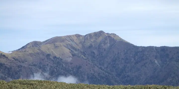
Mount Miune is a 1,894 m peak straddling Miyoshi City in Tokushima Prefecture and Kami City in Kōchi Prefecture, the highest summit in Kōchi Prefecture and the western anchor of the Tsurugi Range within Tsurugisan Quasi-National Park. Listed in the Nihon Nihyaku Meizan, the Shikoku Hyakumeizan, and the prefectural-summits roster, the pyramidal summit rises above an expansive miyama-kuma-zasa grassland on the connecting ridge. The strip of komets-tsutsuji (alpine azalea) and bamboo grass running between Miune and nearby Tengu-zuka is designated a National Natural Monument. The mountain forms a 1,511 ha Forestry Agency Natural Recreation Forest. The standard ascent climbs from the Nagoro trailhead in Higashi-Iya, Miyoshi City — a paved car park with toilets — by way of the forest road, while a longer traverse from Tsurugi via Jirōgyū to Miune is one of the classic Shikoku ridge walks.
Mount Miune at a glance
- Weather: The most settled day in the next 7 days is Sun, November 8: clear, gusts up to 8 m/s. Fri, Nov 6, Sat, Nov 7: strong wind (gusts up to 17 m/s).
- Route: The shortest is Mount Sanrei Return from the Fir Woods up a Bamboo-grass Ridge to the Summit by a Pond That Never Dries: about 6 h 12 min, 9.3 km, about 1,020 m of climbing.
Mount Miune weather (hourly, 14 days)
Sunrise today 06:24, sunset 17:11
| Tue, 11/3 | Wed, 11/4 | Thu, 11/5 | Fri, 11/6 | Sat, 11/7 | Sun, 11/8 | Mon, 11/9 | Tue, 11/10 | Wed, 11/11 | Thu, 11/12 | Fri, 11/13 | Sat, 11/14 | Sun, 11/15 | Mon, 11/16 | Tue, 11/17 | |||||||||||||||||||||||||||||||||||||||||||||||||||||||||||||||||||||||
|---|---|---|---|---|---|---|---|---|---|---|---|---|---|---|---|---|---|---|---|---|---|---|---|---|---|---|---|---|---|---|---|---|---|---|---|---|---|---|---|---|---|---|---|---|---|---|---|---|---|---|---|---|---|---|---|---|---|---|---|---|---|---|---|---|---|---|---|---|---|---|---|---|---|---|---|---|---|---|---|---|---|---|---|---|---|
| Japan time | 15 | 17 | 19 | 21 | 23 | 1 | 3 | 5 | 7 | 9 | 11 | 13 | 15 | 18 | 21 | 0 | 3 | 6 | 9 | 12 | 15 | 18 | 21 | 0 | 3 | 6 | 9 | 12 | 15 | 18 | 21 | 0 | 3 | 6 | 9 | 12 | 15 | 18 | 21 | 0 | 3 | 6 | 9 | 12 | 15 | 18 | 21 | 0 | 3 | 6 | 9 | 15 | 21 | 3 | 9 | 15 | 21 | 3 | 9 | 15 | 21 | 3 | 9 | 15 | 21 | 3 | 9 | 15 | 21 | 3 | 9 | 15 | 21 | 3 | 9 | 15 | 21 | 3 | 9 | 15 | 21 | 3 | 9 | 15 | |
 |   |   |   |   | | | |   | |   | | | | |   | | |   | | | | | | | |   | | |  | | | | | | | | | | | | | | | | | | | | | | | | | | |   | | | | | | | | |   | |   | | | | | | | | | | | | | | | | | ||
| Temperature | °C | 7° | 3° | 2° | 2° | 2° | 2° | 2° | 2° | 2° | 4° | 8° | 8° | 8° | 6° | 6° | 6° | 7° | 6° | 9° | 13° | 12° | 8° | 8° | 9° | 7° | 5° | 4° | 7° | 6° | 2° | 0° | -1° | -2° | -3° | -1° | 1° | 2° | -2° | -4° | -4° | -5° | -5° | 3° | 6° | 5° | 0° | 1° | 1° | 1° | 1° | 3° | 5° | 0° | -2° | 1° | 3° | -2° | -4° | -3° | 1° | -4° | -6° | 1° | 5° | -2° | -1° | 0° | 2° | -3° | -6° | 4° | 7° | 0° | 0° | 7° | 7° | 7° | 6° | 5° | 6° | 2° | -2° | 0° | 4° |
| Precipitation | mm | 1.1 | 0.6 | 1.0 | 0.2 | 0.9 | 1.2 | 0.5 | 0.2 | 1.5 | 0.4 | 0.2 | 0.3 | 0.1 | 0.5 | 0.7 | 5 | 0.4 | 2.1 | 1.8 | 2.2 | 0.4 | |||||||||||||||||||||||||||||||||||||||||||||||||||||||||||||||
| New snow | cm | ||||||||||||||||||||||||||||||||||||||||||||||||||||||||||||||||||||||||||||||||||||
| Snow depth | cm | 0 | 0 | 0 | 0 | 0 | 0 | 0 | 0 | 0 | 0 | 0 | 0 | 0 | 0 | 0 | 0 | 0 | 0 | 0 | 0 | 0 | 0 | 0 | 0 | 0 | 0 | 0 | 0 | 0 | 0 | 0 | 0 | 0 | 0 | 0 | 0 | 0 | 0 | 0 | 0 | 0 | 0 | 0 | 0 | 0 | 0 | 0 | 0 | 0 | 0 | 0 | 0 | 0 | 0 | 0 | 0 | 0 | 0 | 0 | 0 | 0 | 0 | 0 | 0 | 0 | 0 | 0 | 0 | 0 | 0 | 0 | 0 | 0 | 0 | 0 | 0 | 0 | 0 | 0 | 0 | 0 | 0 | 0 | 0 |
| Wind | m/s | 3 | 1 | 1 | 1 | 1 | 2 | 2 | 3 | 3 | 2 | 1 | 1 | 1 | 0 | 0 | 3 | 0 | 1 | 1 | 2 | 3 | 3 | 3 | 3 | 4 | 4 | 4 | 5 | 5 | 4 | 5 | 5 | 5 | 5 | 5 | 4 | 4 | 2 | 2 | 1 | 1 | 1 | 2 | 2 | 2 | 1 | 0 | 1 | 1 | 1 | 2 | 4 | 1 | 0 | 1 | 4 | 4 | 6 | 5 | 5 | 1 | 0 | 1 | 2 | 1 | 3 | 4 | 4 | 2 | 1 | 1 | 2 | 2 | 2 | 4 | 5 | 4 | 1 | 4 | 5 | 3 | 2 | 1 | 2 |
| Wind gusts | m/s | 9 | 9 | 5 | 6 | 5 | 6 | 8 | 8 | 8 | 8 | 7 | 6 | 5 | 5 | 5 | 9 | 9 | 3 | 4 | 7 | 10 | 10 | 12 | 12 | 14 | 15 | 16 | 15 | 16 | 16 | 17 | 17 | 17 | 18 | 17 | 17 | 15 | 13 | 10 | 7 | 6 | 5 | 6 | 7 | 8 | 8 | 3 | 5 | 6 | 6 | 8 | 11 | 11 | 4 | 6 | 12 | 15 | 20 | 20 | 17 | 15 | 6 | 5 | 8 | 7 | 11 | 13 | 13 | 13 | 6 | 5 | 7 | 6 | 8 | 14 | 16 | 18 | 14 | 14 | 17 | 15 | 11 | 6 | 8 |
| Wind dir. | ↓ | ↓ | ↓ | ↓ | ↓ | ↓ | ↓ | ↓ | ↓ | ↓ | ↓ | ↓ | ↓ | ↓ | ↓ | ↓ | ↓ | ↓ | ↓ | ↓ | ↓ | ↓ | ↓ | ↓ | ↓ | ↓ | ↓ | ↓ | ↓ | ↓ | ↓ | ↓ | ↓ | ↓ | ↓ | ↓ | ↓ | ↓ | ↓ | ↓ | ↓ | ↓ | ↓ | ↓ | ↓ | ↓ | ↓ | ↓ | ↓ | ↓ | ↓ | ↓ | ↓ | ↓ | ↓ | ↓ | ↓ | ↓ | ↓ | ↓ | ↓ | ↓ | ↓ | ↓ | ↓ | ↓ | ↓ | ↓ | ↓ | ↓ | ↓ | ↓ | ↓ | ↓ | ↓ | ↓ | ↓ | ↓ | ↓ | ↓ | ↓ | ↓ | ↓ | ↓ | |
Mount Miune hiking routes
- Mount Sanrei Return from the Fir Woods up a Bamboo-grass Ridge to the Summit by a Pond That Never Dries 9.3 km · Ascent 1,017 m 三嶺登山口, 名頃バス停 (Bus stop), 三嶺登山口 Miune Trailhead
- Mount Tsurugi, Jirogyu, and Miune Traverse from Minokoshi to Nagoro 21.0 km · Ascent 1,706 m 見ノ越 (Bus stop), Minokoshi (Aerialway station), 見ノ越駅 (Aerialway station), 見ノ越第一駐車場 (parking) → 三嶺登山口, 名頃バス停 (Bus stop), 三嶺登山口 Miune Trailhead
Hiking times are estimates calculated from the terrain.
Huts, campsites and lodging near Mount Miune
Mountain huts
Lodging
- いやしの温泉郷
- 松浦商店/民宿松浦
- Kouya
Lists that include Mount Miune
Japan 200 Famous Mountains · Japan's 300 Famous Mountains · Highest Peaks by Prefecture · Shikoku 100 Famous Mountains · Elevations of 1003 Mountains of Japan · 1000 Mountains of Japan
Mount Miune facts
- Also known as
- さんれい(高知)
- Elevation
- 1,893 m
- Location
- Miyoshi, Tokushima
33.839405, 133.987681 - National Park
- 剣山国定公園
- Website
- www.rinya.maff.go.jp
- Trail Map
- www.city.kami.lg.jp (PDF)
- Access Information
- www.city.kami.lg.jp
- Wikipedia
- ja.wikipedia.org