
Mount Maruzasa
丸笹山
Tsurugi, Tokushima · Elevation 1,712 m
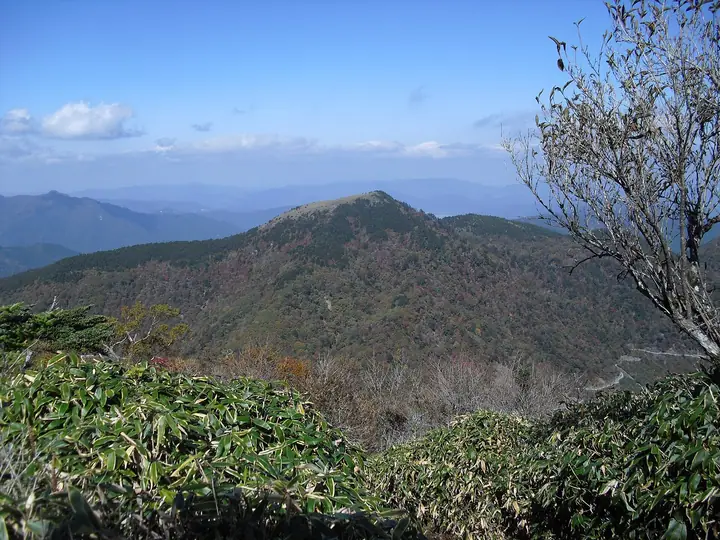
Mount Maruzasa is a 1,711.9 m peak at the convergence of Miyoshi City, Mima City, and Tsurugi Town in Tokushima, set about 2.5 km north of Mount Tsurugi and within Tsurugi-san Quasi-National Park. The gentle summit dome is mantled in bamboo grass, while the surrounding mixed forest — beech, Japanese oak, fir, and other broadleaves — supports a chorus of warblers, robins, blue-and-white flycatchers, and narcissus flycatchers. A promenade-style trail leaves Meoto-ike pond and reaches the summit in about an hour, making this a friendly entry-level peak in the Tsurugi range. The mountain features in Hana no Hyakumeizan and Shikoku Hyakumeizan.
Mount Maruzasa at a glance
- Weather: The most settled day in the next 7 days is Sun, November 8: clear, gusts up to 7 m/s. Fri, Nov 6, Sat, Nov 7: strong wind (gusts up to 16 m/s).
Mount Maruzasa weather (hourly, 14 days)
Sunrise today 06:24, sunset 17:11
| Tue, 11/3 | Wed, 11/4 | Thu, 11/5 | Fri, 11/6 | Sat, 11/7 | Sun, 11/8 | Mon, 11/9 | Tue, 11/10 | Wed, 11/11 | Thu, 11/12 | Fri, 11/13 | Sat, 11/14 | Sun, 11/15 | Mon, 11/16 | Tue, 11/17 | |||||||||||||||||||||||||||||||||||||||||||||||||||||||||||||||||||||||
|---|---|---|---|---|---|---|---|---|---|---|---|---|---|---|---|---|---|---|---|---|---|---|---|---|---|---|---|---|---|---|---|---|---|---|---|---|---|---|---|---|---|---|---|---|---|---|---|---|---|---|---|---|---|---|---|---|---|---|---|---|---|---|---|---|---|---|---|---|---|---|---|---|---|---|---|---|---|---|---|---|---|---|---|---|---|
| Japan time | 15 | 17 | 19 | 21 | 23 | 1 | 3 | 5 | 7 | 9 | 11 | 13 | 15 | 18 | 21 | 0 | 3 | 6 | 9 | 12 | 15 | 18 | 21 | 0 | 3 | 6 | 9 | 12 | 15 | 18 | 21 | 0 | 3 | 6 | 9 | 12 | 15 | 18 | 21 | 0 | 3 | 6 | 9 | 12 | 15 | 18 | 21 | 0 | 3 | 6 | 9 | 15 | 21 | 3 | 9 | 15 | 21 | 3 | 9 | 15 | 21 | 3 | 9 | 15 | 21 | 3 | 9 | 15 | 21 | 3 | 9 | 15 | 21 | 3 | 9 | 15 | 21 | 3 | 9 | 15 | 21 | 3 | 9 | 15 | |
 |   |   |   |   | | | |   | |   | | | |   | | | |   | | | | | | | |   | | |  | | | | | | | | | | | | | | | | | | | | | | | | | | | | | | | | | | | |   | | | | | | | | | | | | | | | | | | | ||
| Temperature | °C | 8° | 5° | 4° | 3° | 3° | 3° | 3° | 3° | 3° | 5° | 9° | 9° | 10° | 7° | 7° | 7° | 8° | 8° | 10° | 14° | 14° | 9° | 10° | 10° | 9° | 6° | 6° | 9° | 8° | 3° | 1° | 0° | -1° | -1° | 0° | 3° | 3° | -2° | -2° | -3° | -4° | -3° | 5° | 8° | 6° | 2° | 2° | 1° | 2° | 2° | 5° | 6° | 1° | -1° | 3° | 5° | -1° | -2° | -1° | 2° | -3° | -5° | 3° | 7° | -1° | 0° | 2° | 3° | -2° | -3° | 5° | 10° | 1° | 1° | 8° | 8° | 8° | 7° | 7° | 8° | 3° | -1° | 2° | 7° |
| Precipitation | mm | 0.2 | 1.9 | 0.5 | 0.8 | 0.2 | 0.4 | 0.8 | 0.2 | 0.8 | 0.2 | 0.2 | 0.2 | 0.4 | 0.5 | 7 | 0.4 | 0.9 | 1.2 | 2.7 | 0.6 | ||||||||||||||||||||||||||||||||||||||||||||||||||||||||||||||||
| New snow | cm | ||||||||||||||||||||||||||||||||||||||||||||||||||||||||||||||||||||||||||||||||||||
| Snow depth | cm | 0 | 0 | 0 | 0 | 0 | 0 | 0 | 0 | 0 | 0 | 0 | 0 | 0 | 0 | 0 | 0 | 0 | 0 | 0 | 0 | 0 | 0 | 0 | 0 | 0 | 0 | 0 | 0 | 0 | 0 | 0 | 0 | 0 | 0 | 0 | 0 | 0 | 0 | 0 | 0 | 0 | 0 | 0 | 0 | 0 | 0 | 0 | 0 | 0 | 0 | 0 | 0 | 0 | 0 | 0 | 0 | 0 | 0 | 0 | 0 | 0 | 0 | 0 | 0 | 0 | 0 | 0 | 0 | 0 | 0 | 0 | 0 | 0 | 0 | 0 | 0 | 0 | 0 | 0 | 0 | 0 | 0 | 0 | 0 |
| Wind | m/s | 3 | 1 | 1 | 1 | 1 | 1 | 2 | 2 | 2 | 2 | 2 | 1 | 1 | 1 | 1 | 2 | 1 | 0 | 1 | 1 | 2 | 3 | 3 | 3 | 4 | 4 | 4 | 5 | 5 | 3 | 4 | 4 | 4 | 4 | 4 | 4 | 4 | 2 | 1 | 1 | 1 | 0 | 2 | 2 | 2 | 1 | 0 | 1 | 2 | 1 | 2 | 3 | 1 | 1 | 1 | 4 | 4 | 6 | 5 | 5 | 1 | 0 | 1 | 2 | 1 | 2 | 4 | 4 | 0 | 0 | 1 | 1 | 1 | 2 | 4 | 4 | 4 | 1 | 4 | 5 | 3 | 1 | 1 | 2 |
| Wind gusts | m/s | 9 | 9 | 5 | 6 | 4 | 5 | 6 | 6 | 6 | 6 | 6 | 6 | 5 | 6 | 6 | 7 | 9 | 4 | 5 | 6 | 9 | 10 | 13 | 13 | 13 | 15 | 15 | 16 | 15 | 15 | 16 | 17 | 17 | 18 | 16 | 16 | 15 | 13 | 9 | 7 | 5 | 5 | 7 | 7 | 7 | 7 | 3 | 6 | 8 | 7 | 7 | 10 | 10 | 5 | 6 | 12 | 15 | 19 | 19 | 17 | 14 | 5 | 5 | 8 | 6 | 10 | 12 | 13 | 12 | 4 | 4 | 6 | 6 | 7 | 13 | 16 | 18 | 14 | 13 | 16 | 15 | 10 | 6 | 8 |
| Wind dir. | ↓ | ↓ | ↓ | ↓ | ↓ | ↓ | ↓ | ↓ | ↓ | ↓ | ↓ | ↓ | ↓ | ↓ | ↓ | ↓ | ↓ | ↓ | ↓ | ↓ | ↓ | ↓ | ↓ | ↓ | ↓ | ↓ | ↓ | ↓ | ↓ | ↓ | ↓ | ↓ | ↓ | ↓ | ↓ | ↓ | ↓ | ↓ | ↓ | ↓ | ↓ | ↓ | ↓ | ↓ | ↓ | ↓ | ↓ | ↓ | ↓ | ↓ | ↓ | ↓ | ↓ | ↓ | ↓ | ↓ | ↓ | ↓ | ↓ | ↓ | ↓ | ↓ | ↓ | ↓ | ↓ | ↓ | ↓ | ↓ | ↓ | ↓ | ↓ | ↓ | ↓ | ↓ | ↓ | ↓ | ↓ | ↓ | ↓ | ↓ | ↓ | ↓ | ↓ | ↓ | |
Huts, campsites and lodging near Mount Maruzasa
Mountain huts
- 雲海荘 2026: open April 28–November 23 · reservation required · sleeps 70
- Tsurugi Mountain Summit Hut 2026: open April 28–November 23
- 剣山一の森ヒュッテ
Campsites
- 奥祖谷二重かずら橋キャンプ場
Lodging
- 剣神社簡易宿泊所
- 民宿まつうら
- 民宿 平家の宿
- 霧の峰
- ラ・フォーレつるぎ山
Lists that include Mount Maruzasa
100 Famous Mountains of Flowers · Shikoku 100 Famous Mountains · Elevations of 1003 Mountains of Japan
Mount Maruzasa facts
- Elevation
- 1,712 m
- Location
- Tsurugi, Tokushima
33.874237, 134.089884 - National Park
- 剣山国定公園
- Wikipedia
- ja.wikipedia.org