
Mount Surikogi
摺古木山
Iida, Nagano / Okuwa, Nagano · Elevation 2,169 m
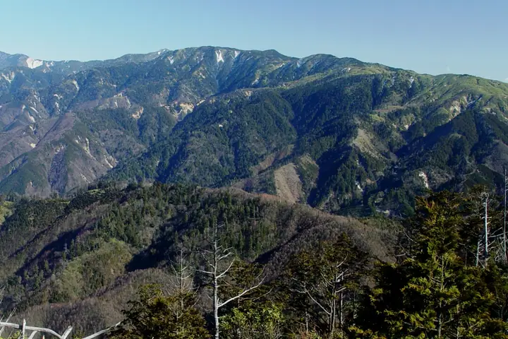
Mount Surikogi is a 2,169-metre peak on the main ridge of the southern Kiso Mountains, straddling Iida City and Ōkuwa Village in Nagano Prefecture, with a first-class triangulation marker on its summit. The mountain lies within Chūō-Alps Quasi-National Park and is renowned for its rhododendron thickets. The standard ascent climbs from the Surikogi Mountain Rest House at the end of the Higashisawa Forest Road above the abandoned Ōdaira post-village, and it serves as the southern staging point for traverses to Anpeiji-yama and the Central Alps main spine.
Mount Surikogi at a glance
- Weather: The most settled day in the next 7 days is Sun, November 8: clear, gusts up to 8 m/s.
Mount Surikogi weather (hourly, 14 days)
Sunrise today 06:12, sunset 16:53
| Tue, 11/3 | Wed, 11/4 | Thu, 11/5 | Fri, 11/6 | Sat, 11/7 | Sun, 11/8 | Mon, 11/9 | Tue, 11/10 | Wed, 11/11 | Thu, 11/12 | Fri, 11/13 | Sat, 11/14 | Sun, 11/15 | Mon, 11/16 | Tue, 11/17 | |||||||||||||||||||||||||||||||||||||||||||||||||||||||||||||||||||||||
|---|---|---|---|---|---|---|---|---|---|---|---|---|---|---|---|---|---|---|---|---|---|---|---|---|---|---|---|---|---|---|---|---|---|---|---|---|---|---|---|---|---|---|---|---|---|---|---|---|---|---|---|---|---|---|---|---|---|---|---|---|---|---|---|---|---|---|---|---|---|---|---|---|---|---|---|---|---|---|---|---|---|---|---|---|---|
| Japan time | 21 | 23 | 1 | 3 | 5 | 7 | 9 | 11 | 13 | 15 | 17 | 19 | 21 | 0 | 3 | 6 | 9 | 12 | 15 | 18 | 21 | 0 | 3 | 6 | 9 | 12 | 15 | 18 | 21 | 0 | 3 | 6 | 9 | 12 | 15 | 18 | 21 | 0 | 3 | 6 | 9 | 12 | 15 | 18 | 21 | 0 | 3 | 6 | 9 | 12 | 15 | 21 | 3 | 9 | 15 | 21 | 3 | 9 | 15 | 21 | 3 | 9 | 15 | 21 | 3 | 9 | 15 | 21 | 3 | 9 | 15 | 21 | 3 | 9 | 15 | 21 | 3 | 9 | 15 | 21 | 3 | 9 | 15 | 21 | |
  | | | | |   |   | |   | |   | |   | | |   |   | | | | | | | | | | |   | | | | | | |  |  | | | | | | | | | | | | |   | | | |   | | | |   | | | |  | | | | | | | | | | | | | | | | | |   | | | | | | ||
| Temperature | °C | 1° | 1° | 2° | 1° | 1° | 1° | 7° | 10° | 10° | 8° | 5° | 5° | 5° | 4° | 4° | 4° | 9° | 11° | 11° | 7° | 6° | 5° | 5° | 5° | 7° | 9° | 7° | 2° | -1° | -2° | -1° | -2° | 1° | 4° | 2° | -4° | -6° | -7° | -7° | -7° | 4° | 6° | 5° | 0° | -2° | 1° | 1° | 2° | 3° | 8° | 6° | -2° | -2° | 3° | 3° | -1° | -4° | -3° | 2° | -5° | -5° | 2° | 3° | -5° | -4° | 2° | 5° | -5° | -5° | 2° | 4° | -3° | 0° | 5° | 5° | 4° | 4° | 6° | 8° | -2° | -2° | 3° | 3° | 1° |
| Precipitation | mm | 0.2 | 6 | 10 | 2.8 | 0.5 | 0.2 | 7 | 2.2 | 0.3 | 0.2 | 0.2 | 0.6 | 0.2 | 1.2 | 0.5 | 0.7 | 24 | 15 | 0.6 | 1.0 | 0.3 | 0.9 | ||||||||||||||||||||||||||||||||||||||||||||||||||||||||||||||
| New snow | cm | <.1 | |||||||||||||||||||||||||||||||||||||||||||||||||||||||||||||||||||||||||||||||||||
| Snow depth | cm | 0 | 0 | 0 | 0 | 0 | 0 | 0 | 0 | 0 | 0 | 0 | 0 | 0 | 0 | 0 | 0 | 0 | 0 | 0 | 0 | 0 | 0 | 0 | 0 | 0 | 0 | 0 | 0 | 0 | 0 | 0 | 0 | 0 | 0 | 0 | 0 | 0 | 0 | 0 | 0 | 0 | 0 | 0 | 0 | 0 | 0 | 0 | 0 | 0 | 0 | 0 | 0 | 0 | 0 | 0 | 0 | 0 | 0 | 0 | 0 | 0 | 0 | 0 | 0 | 0 | 0 | 0 | 0 | 0 | 0 | 0 | 0 | 0 | 0 | 0 | 0 | 0 | 0 | 0 | 0 | 0 | 0 | 0 | 0 |
| Wind | m/s | 0 | 0 | 0 | 0 | 0 | 1 | 1 | 1 | 2 | 1 | 0 | 1 | 1 | 2 | 1 | 1 | 0 | 1 | 1 | 0 | 1 | 0 | 1 | 1 | 1 | 3 | 3 | 2 | 2 | 2 | 2 | 1 | 2 | 3 | 2 | 2 | 1 | 1 | 1 | 1 | 1 | 2 | 1 | 0 | 0 | 1 | 1 | 1 | 0 | 3 | 2 | 0 | 1 | 2 | 3 | 2 | 3 | 2 | 2 | 1 | 0 | 2 | 2 | 1 | 1 | 2 | 1 | 1 | 0 | 1 | 2 | 0 | 1 | 2 | 1 | 0 | 0 | 2 | 3 | 2 | 1 | 1 | 2 | 0 |
| Wind gusts | m/s | 4 | 4 | 4 | 4 | 4 | 3 | 4 | 7 | 9 | 9 | 5 | 4 | 5 | 11 | 12 | 9 | 6 | 8 | 7 | 7 | 8 | 10 | 13 | 12 | 8 | 12 | 13 | 13 | 10 | 9 | 10 | 10 | 10 | 13 | 13 | 12 | 10 | 9 | 8 | 7 | 5 | 8 | 8 | 6 | 6 | 8 | 9 | 8 | 8 | 11 | 11 | 9 | 5 | 8 | 13 | 11 | 16 | 16 | 14 | 9 | 7 | 8 | 10 | 7 | 6 | 11 | 11 | 8 | 6 | 4 | 9 | 8 | 7 | 9 | 11 | 14 | 13 | 10 | 13 | 12 | 9 | 5 | 9 | 7 |
| Wind dir. | ↓ | ↓ | ↓ | ↓ | ↓ | ↓ | ↓ | ↓ | ↓ | ↓ | ↓ | ↓ | ↓ | ↓ | ↓ | ↓ | ↓ | ↓ | ↓ | ↓ | ↓ | ↓ | ↓ | ↓ | ↓ | ↓ | ↓ | ↓ | ↓ | ↓ | ↓ | ↓ | ↓ | ↓ | ↓ | ↓ | ↓ | ↓ | ↓ | ↓ | ↓ | ↓ | ↓ | ↓ | ↓ | ↓ | ↓ | ↓ | ↓ | ↓ | ↓ | ↓ | ↓ | ↓ | ↓ | ↓ | ↓ | ↓ | ↓ | ↓ | ↓ | ↓ | ↓ | ↓ | ↓ | ↓ | ↓ | ↓ | ↓ | ↓ | ↓ | ↓ | ↓ | ↓ | ↓ | ↓ | ↓ | ↓ | ↓ | ↓ | ↓ | ↓ | ↓ | ↓ | |
Huts, campsites and lodging near Mount Surikogi
Mountain huts
Lists that include Mount Surikogi
100 Famous Mountains with First-order Triangulation Points · Elevations of 1003 Mountains of Japan
Mount Surikogi facts
- Also known as
- 摺小木山(三角点名)
- Elevation
- 2,169 m
- Location
- Iida, Nagano / Okuwa, Nagano
35.612878, 137.737564 - National Park
- 中央アルプス国定公園
- Wikipedia
- ja.wikipedia.org