
Mt. Eboshidake
烏帽子岳
Iijima, Nagano · Elevation 2,194 m
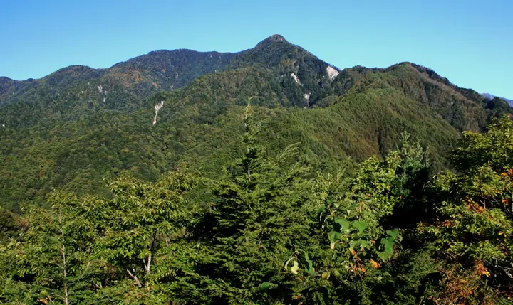
Mt. Eboshidake is a 2,194-meter peak in Matsukawa Town, Shimoina District, Nagano Prefecture — a foreground summit of the southern Central Alps ridge lying east of Mt. Nenjōdake. From Hatouchi Pass (1,118 m) the trail ascends past Mt. Kohachirō to the summit and continues north along the ridge to Mt. Ikenodaira and Mt. Nenjōdake. Its eboshi-cap silhouette dominates the view from the Ina Valley, and the mountain is included in the Shinshū Furusato 120, Nagano Meihō 100, and Tōkai Weekend 120 lists.
Mt. Eboshidake at a glance
- Weather: The most settled day in the next 7 days is Sun, November 8: clear, gusts up to 7 m/s.
- Route: The shortest is Mount Kohachiro and Mount Eboshi Circuit from Hatouchi Pass: about 6 h 17 min, 8.9 km, about 1,150 m of climbing.
Mt. Eboshidake weather (hourly, 14 days)
Sunrise today 06:12, sunset 16:53
| Tue, 11/3 | Wed, 11/4 | Thu, 11/5 | Fri, 11/6 | Sat, 11/7 | Sun, 11/8 | Mon, 11/9 | Tue, 11/10 | Wed, 11/11 | Thu, 11/12 | Fri, 11/13 | Sat, 11/14 | Sun, 11/15 | Mon, 11/16 | Tue, 11/17 | |||||||||||||||||||||||||||||||||||||||||||||||||||||||||||||||||||||||
|---|---|---|---|---|---|---|---|---|---|---|---|---|---|---|---|---|---|---|---|---|---|---|---|---|---|---|---|---|---|---|---|---|---|---|---|---|---|---|---|---|---|---|---|---|---|---|---|---|---|---|---|---|---|---|---|---|---|---|---|---|---|---|---|---|---|---|---|---|---|---|---|---|---|---|---|---|---|---|---|---|---|---|---|---|---|
| Japan time | 15 | 17 | 19 | 21 | 23 | 1 | 3 | 5 | 7 | 9 | 11 | 13 | 15 | 18 | 21 | 0 | 3 | 6 | 9 | 12 | 15 | 18 | 21 | 0 | 3 | 6 | 9 | 12 | 15 | 18 | 21 | 0 | 3 | 6 | 9 | 12 | 15 | 18 | 21 | 0 | 3 | 6 | 9 | 12 | 15 | 18 | 21 | 0 | 3 | 6 | 9 | 15 | 21 | 3 | 9 | 15 | 21 | 3 | 9 | 15 | 21 | 3 | 9 | 15 | 21 | 3 | 9 | 15 | 21 | 3 | 9 | 15 | 21 | 3 | 9 | 15 | 21 | 3 | 9 | 15 | 21 | 3 | 9 | 15 | |
 |   | |  | | | | |   | | |   |   |   | |   | | |   | | |   | | | | |   |   | |  | | | | | | | | | | | | | | | | | | | | | | | |   | | | | | | |   |  | | | | | | | | | | | | | | | | | | | | | | | ||
| Temperature | °C | 10° | 4° | 2° | 1° | 1° | 1° | 0° | 0° | 0° | 5° | 8° | 10° | 9° | 5° | 4° | 3° | 3° | 2° | 6° | 8° | 8° | 5° | 3° | 3° | 4° | 4° | 6° | 10° | 8° | 1° | -1° | -2° | -2° | -3° | 1° | 4° | 3° | -4° | -7° | -7° | -8° | -7° | 4° | 7° | 6° | 0° | 0° | 0° | 0° | 0° | 4° | 6° | -2° | -2° | 2° | 4° | -1° | -4° | -2° | 3° | -5° | -5° | 1° | 4° | -5° | -5° | 3° | 6° | -5° | -6° | 2° | 5° | -3° | -2° | 4° | 5° | 3° | 3° | 6° | 9° | -2° | -2° | 2° | 3° |
| Precipitation | mm | 4.8 | 16 | 1.7 | 0.9 | 1.0 | 0.4 | 1.7 | 0.3 | 0.4 | 0.6 | 0.2 | 0.9 | 0.8 | 0.1 | 0.6 | 24 | 16 | 1.0 | 1.8 | 0.2 | ||||||||||||||||||||||||||||||||||||||||||||||||||||||||||||||||
| New snow | cm | ||||||||||||||||||||||||||||||||||||||||||||||||||||||||||||||||||||||||||||||||||||
| Snow depth | cm | 0 | 0 | 0 | 0 | 0 | 0 | 0 | 0 | 0 | 0 | 0 | 0 | 0 | 0 | 0 | 0 | 0 | 0 | 0 | 0 | 0 | 0 | 0 | 0 | 0 | 0 | 0 | 0 | 0 | 0 | 0 | 0 | 0 | 0 | 0 | 0 | 0 | 0 | 0 | 0 | 0 | 0 | 0 | 0 | 0 | 0 | 0 | 0 | 0 | 0 | 0 | 0 | 0 | 0 | 0 | 0 | 0 | 0 | 0 | 0 | 0 | 0 | 0 | 0 | 0 | 0 | 0 | 0 | 0 | 0 | 0 | 0 | 0 | 0 | 0 | 0 | 0 | 0 | 0 | 0 | 0 | 0 | 0 | 0 |
| Wind | m/s | 1 | 1 | 0 | 1 | 0 | 0 | 1 | 1 | 1 | 1 | 1 | 2 | 1 | 0 | 2 | 2 | 2 | 2 | 2 | 1 | 1 | 1 | 1 | 1 | 1 | 1 | 1 | 2 | 2 | 1 | 2 | 2 | 2 | 2 | 2 | 1 | 2 | 2 | 2 | 2 | 2 | 1 | 1 | 1 | 1 | 0 | 2 | 1 | 2 | 1 | 1 | 2 | 1 | 1 | 1 | 3 | 1 | 2 | 3 | 2 | 2 | 0 | 2 | 2 | 1 | 1 | 2 | 1 | 2 | 1 | 1 | 2 | 1 | 1 | 2 | 1 | 1 | 1 | 1 | 2 | 2 | 1 | 1 | 2 |
| Wind gusts | m/s | 6 | 7 | 4 | 5 | 5 | 5 | 4 | 4 | 5 | 6 | 7 | 9 | 9 | 7 | 6 | 7 | 12 | 9 | 8 | 6 | 7 | 7 | 6 | 7 | 9 | 8 | 7 | 10 | 10 | 9 | 9 | 10 | 10 | 9 | 10 | 10 | 10 | 10 | 9 | 8 | 8 | 8 | 7 | 7 | 7 | 6 | 8 | 8 | 8 | 8 | 7 | 8 | 7 | 4 | 7 | 13 | 10 | 13 | 15 | 14 | 10 | 8 | 8 | 11 | 8 | 6 | 9 | 10 | 10 | 7 | 5 | 8 | 8 | 7 | 9 | 11 | 15 | 14 | 9 | 10 | 11 | 10 | 5 | 9 |
| Wind dir. | ↓ | ↓ | ↓ | ↓ | ↓ | ↓ | ↓ | ↓ | ↓ | ↓ | ↓ | ↓ | ↓ | ↓ | ↓ | ↓ | ↓ | ↓ | ↓ | ↓ | ↓ | ↓ | ↓ | ↓ | ↓ | ↓ | ↓ | ↓ | ↓ | ↓ | ↓ | ↓ | ↓ | ↓ | ↓ | ↓ | ↓ | ↓ | ↓ | ↓ | ↓ | ↓ | ↓ | ↓ | ↓ | ↓ | ↓ | ↓ | ↓ | ↓ | ↓ | ↓ | ↓ | ↓ | ↓ | ↓ | ↓ | ↓ | ↓ | ↓ | ↓ | ↓ | ↓ | ↓ | ↓ | ↓ | ↓ | ↓ | ↓ | ↓ | ↓ | ↓ | ↓ | ↓ | ↓ | ↓ | ↓ | ↓ | ↓ | ↓ | ↓ | ↓ | ↓ | ↓ | |
Mt. Eboshidake hiking routes
Hiking times are estimates calculated from the terrain.
Huts, campsites and lodging near Mt. Eboshidake
Mountain huts
Mt. Eboshidake facts
- Elevation
- 2,194 m
- Location
- Iijima, Nagano
35.654376, 137.838802 - Website
- www.town.matsukawa.lg.jp
- Trail Map
- www.town.matsukawa.lg.jp (PDF)