
Mount Kazakoshi
風越山
Iida, Nagano · Elevation 1,535 m
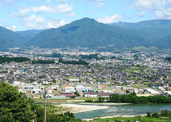
Mount Kazakoshi is a 1,535 m granite peak in the western part of Iida City, Nagano, a foothill of the Central Alps that locals also know as Gongen-yama and embrace as the city's emblem. It has been revered as a sacred mountain since ancient times; the Hakusan Shrine Inner Sanctuary just below the summit, built in 1509 during the Muromachi period, is a designated Important Cultural Property of Japan. The summit beech and Japanese oak forest, the iwauchiwa habitat, and the benimansaku (red witch-hazel) grove are all protected as Iida City natural monuments. Six trails climb the mountain, with the Hondō (Taki-no-sawa) route as the standard, and the peak features in Shin Hana no Hyakumeizan, Shinshū Hyakumeizan, and Nagano's Meihō Hyakusen.
Mount Kazakoshi at a glance
- Weather: The most settled day in the next 7 days is Sun, November 8: clear, gusts up to 7 m/s.
- Route: The shortest is Mount Kazakoshi Oshido Course Return: about 5 h 21 min, 9.5 km, about 1,050 m of climbing.
Mount Kazakoshi weather (hourly, 14 days)
Sunrise today 06:12, sunset 16:53
| Tue, 11/3 | Wed, 11/4 | Thu, 11/5 | Fri, 11/6 | Sat, 11/7 | Sun, 11/8 | Mon, 11/9 | Tue, 11/10 | Wed, 11/11 | Thu, 11/12 | Fri, 11/13 | Sat, 11/14 | Sun, 11/15 | Mon, 11/16 | Tue, 11/17 | |||||||||||||||||||||||||||||||||||||||||||||||||||||||||||||||||||||||
|---|---|---|---|---|---|---|---|---|---|---|---|---|---|---|---|---|---|---|---|---|---|---|---|---|---|---|---|---|---|---|---|---|---|---|---|---|---|---|---|---|---|---|---|---|---|---|---|---|---|---|---|---|---|---|---|---|---|---|---|---|---|---|---|---|---|---|---|---|---|---|---|---|---|---|---|---|---|---|---|---|---|---|---|---|---|
| Japan time | 15 | 17 | 19 | 21 | 23 | 1 | 3 | 5 | 7 | 9 | 11 | 13 | 15 | 18 | 21 | 0 | 3 | 6 | 9 | 12 | 15 | 18 | 21 | 0 | 3 | 6 | 9 | 12 | 15 | 18 | 21 | 0 | 3 | 6 | 9 | 12 | 15 | 18 | 21 | 0 | 3 | 6 | 9 | 12 | 15 | 18 | 21 | 0 | 3 | 6 | 9 | 15 | 21 | 3 | 9 | 15 | 21 | 3 | 9 | 15 | 21 | 3 | 9 | 15 | 21 | 3 | 9 | 15 | 21 | 3 | 9 | 15 | 21 | 3 | 9 | 15 | 21 | 3 | 9 | 15 | 21 | 3 | 9 | 15 | |
 |   |  | | | | | |   | | |   | |   | | | | |   | | |   |   | | | | | | |  | |   | |   | | | | | | | | | | | | | | | | | | | | | | | | | | |   |  | | | | | | | | | | | | |   |   | | | |   |  | | | | ||
| Temperature | °C | 12° | 7° | 5° | 4° | 4° | 4° | 4° | 3° | 4° | 10° | 12° | 14° | 12° | 8° | 8° | 7° | 7° | 7° | 10° | 12° | 11° | 9° | 8° | 7° | 7° | 8° | 9° | 13° | 11° | 5° | 2° | 1° | 0° | 0° | 3° | 7° | 6° | -1° | -3° | -5° | -5° | -5° | 7° | 10° | 8° | 3° | 3° | 3° | 3° | 3° | 8° | 9° | 1° | 1° | 6° | 7° | 3° | -1° | 1° | 6° | -2° | -2° | 5° | 7° | -2° | -2° | 6° | 9° | -1° | -1° | 5° | 8° | -1° | 1° | 8° | 8° | 6° | 7° | 9° | 13° | 1° | 2° | 6° | 7° |
| Precipitation | mm | 0.1 | 0.2 | 6 | 13 | 1.2 | 0.7 | 0.1 | 1.2 | 0.2 | 0.1 | 1.2 | 2.9 | 0.1 | 1.1 | 0.8 | 1.7 | 26 | 16 | 0.3 | 0.7 | 0.3 | |||||||||||||||||||||||||||||||||||||||||||||||||||||||||||||||
| New snow | cm | ||||||||||||||||||||||||||||||||||||||||||||||||||||||||||||||||||||||||||||||||||||
| Snow depth | cm | 0 | 0 | 0 | 0 | 0 | 0 | 0 | 0 | 0 | 0 | 0 | 0 | 0 | 0 | 0 | 0 | 0 | 0 | 0 | 0 | 0 | 0 | 0 | 0 | 0 | 0 | 0 | 0 | 0 | 0 | 0 | 0 | 0 | 0 | 0 | 0 | 0 | 0 | 0 | 0 | 0 | 0 | 0 | 0 | 0 | 0 | 0 | 0 | 0 | 0 | 0 | 0 | 0 | 0 | 0 | 0 | 0 | 0 | 0 | 0 | 0 | 0 | 0 | 0 | 0 | 0 | 0 | 0 | 0 | 0 | 0 | 0 | 0 | 0 | 0 | 0 | 0 | 0 | 0 | 0 | 0 | 0 | 0 | 0 |
| Wind | m/s | 3 | 1 | 0 | 0 | 0 | 0 | 0 | 1 | 1 | 1 | 1 | 2 | 1 | 1 | 1 | 1 | 1 | 1 | 1 | 0 | 1 | 1 | 1 | 1 | 1 | 2 | 2 | 5 | 4 | 2 | 2 | 3 | 2 | 2 | 3 | 5 | 4 | 2 | 2 | 2 | 2 | 1 | 0 | 2 | 1 | 1 | 0 | 1 | 1 | 1 | 1 | 3 | 1 | 0 | 1 | 3 | 2 | 4 | 2 | 2 | 1 | 0 | 1 | 2 | 1 | 2 | 1 | 1 | 1 | 0 | 0 | 2 | 1 | 1 | 0 | 1 | 1 | 1 | 2 | 4 | 2 | 1 | 1 | 2 |
| Wind gusts | m/s | 9 | 8 | 4 | 2 | 2 | 2 | 2 | 2 | 2 | 5 | 6 | 7 | 7 | 5 | 4 | 8 | 9 | 5 | 4 | 5 | 4 | 4 | 4 | 4 | 5 | 7 | 7 | 13 | 14 | 12 | 9 | 9 | 9 | 9 | 9 | 14 | 14 | 11 | 7 | 6 | 6 | 5 | 5 | 7 | 7 | 4 | 3 | 4 | 4 | 5 | 5 | 10 | 9 | 3 | 5 | 10 | 9 | 15 | 14 | 10 | 8 | 4 | 4 | 9 | 8 | 6 | 7 | 8 | 7 | 4 | 3 | 9 | 8 | 4 | 4 | 7 | 9 | 9 | 6 | 12 | 12 | 5 | 4 | 8 |
| Wind dir. | ↓ | ↓ | ↓ | ↓ | ↓ | ↓ | ↓ | ↓ | ↓ | ↓ | ↓ | ↓ | ↓ | ↓ | ↓ | ↓ | ↓ | ↓ | ↓ | ↓ | ↓ | ↓ | ↓ | ↓ | ↓ | ↓ | ↓ | ↓ | ↓ | ↓ | ↓ | ↓ | ↓ | ↓ | ↓ | ↓ | ↓ | ↓ | ↓ | ↓ | ↓ | ↓ | ↓ | ↓ | ↓ | ↓ | ↓ | ↓ | ↓ | ↓ | ↓ | ↓ | ↓ | ↓ | ↓ | ↓ | ↓ | ↓ | ↓ | ↓ | ↓ | ↓ | ↓ | ↓ | ↓ | ↓ | ↓ | ↓ | ↓ | ↓ | ↓ | ↓ | ↓ | ↓ | ↓ | ↓ | ↓ | ↓ | ↓ | ↓ | ↓ | ↓ | ↓ | ↓ | |
Mount Kazakoshi hiking routes
Hiking times are estimates calculated from the terrain.
Huts, campsites and lodging near Mount Kazakoshi
Mountain huts
- Kasamatsu-toge Cabin
Campsites
- Myōkin Park Camping Ground
- RVパーク飯田さるくら
- Nosokoyama Forest Park Camping Ground
Lodging
- Nonbisō
- 風の山
- ホテル弥生
Lists that include Mount Kazakoshi
New 100 Famous Flower Mountains · Tokai 100 Mountains · Shinshu 100 Famous Mountains · Elevations of 1003 Mountains of Japan
Mount Kazakoshi facts
- Also known as
- 権現山
- Elevation
- 1,535 m
- Location
- Iida, Nagano
35.549477, 137.783811 - Website
- db.go-nagano.net
- Trail Map
- www.kazakosiyamawoaisurukai.com
- Access Information
- www.city.iida.lg.jp
- Wikipedia
- ja.wikipedia.org