
Mount Anpeiji
安平路山
Okuwa, Nagano / Iida, Nagano · Elevation 2,363 m
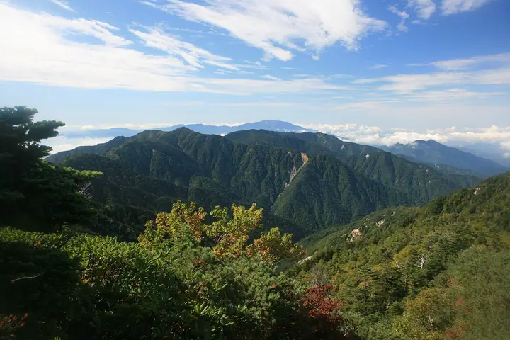
Mount Anpeiji is a 2,363 m peak straddling Iida City and Ōkuwa Village (Kiso District) in Nagano Prefecture, on the southern main ridge of the Kiso Range (Central Japanese Alps). The summit lies below the tree line and is cloaked in conifer forest and head-high kuma-zasa bamboo, allowing little view, but the mountain feeds the headwaters of the Kosumo, Yotagiri, and Iida-Matsu rivers and is listed in the Nihon Nihyaku Meizan and the Shinshū Hyakumeizan. Its bamboo-choked ridges make it one of the most demanding bushwhacks in the Central Alps. The single trail starts at the historic post-village Ōdairajuku on the old Ōdaira highway, follows the Higashi-zawa forest road past the Surikogi Nature Park rest house, and traverses Surikogi-yama and Shirabiso-yama to the summit — roughly 8.5 hours round-trip, typically broken with an overnight at the unstaffed Anpeiji-goya in the saddle west of the summit.
Mount Anpeiji at a glance
- Weather: The most settled day in the next 7 days is Sun, November 8: clear, gusts up to 8 m/s.
Mount Anpeiji weather (hourly, 14 days)
Sunrise today 06:12, sunset 16:53
| Tue, 11/3 | Wed, 11/4 | Thu, 11/5 | Fri, 11/6 | Sat, 11/7 | Sun, 11/8 | Mon, 11/9 | Tue, 11/10 | Wed, 11/11 | Thu, 11/12 | Fri, 11/13 | Sat, 11/14 | Sun, 11/15 | Mon, 11/16 | Tue, 11/17 | |||||||||||||||||||||||||||||||||||||||||||||||||||||||||||||||||||||||
|---|---|---|---|---|---|---|---|---|---|---|---|---|---|---|---|---|---|---|---|---|---|---|---|---|---|---|---|---|---|---|---|---|---|---|---|---|---|---|---|---|---|---|---|---|---|---|---|---|---|---|---|---|---|---|---|---|---|---|---|---|---|---|---|---|---|---|---|---|---|---|---|---|---|---|---|---|---|---|---|---|---|---|---|---|---|
| Japan time | 15 | 17 | 19 | 21 | 23 | 1 | 3 | 5 | 7 | 9 | 11 | 13 | 15 | 18 | 21 | 0 | 3 | 6 | 9 | 12 | 15 | 18 | 21 | 0 | 3 | 6 | 9 | 12 | 15 | 18 | 21 | 0 | 3 | 6 | 9 | 12 | 15 | 18 | 21 | 0 | 3 | 6 | 9 | 12 | 15 | 18 | 21 | 0 | 3 | 6 | 9 | 15 | 21 | 3 | 9 | 15 | 21 | 3 | 9 | 15 | 21 | 3 | 9 | 15 | 21 | 3 | 9 | 15 | 21 | 3 | 9 | 15 | 21 | 3 | 9 | 15 | 21 | 3 | 9 | 15 | 21 | 3 | 9 | 15 | |
 |   |  | | | | | |   | | |   | |   | |   | | |   |   |   | |   | | | | |   | |  | | | | | | | | | | | | | | | |   | | | | | | | |   | | | |   | | | |  | | | | | | | | | | | | | | | | | | | | | | | ||
| Temperature | °C | 8° | 3° | 1° | 0° | 0° | 1° | 0° | -1° | -1° | 6° | 8° | 9° | 8° | 4° | 4° | 3° | 3° | 3° | 6° | 7° | 7° | 4° | 3° | 3° | 4° | 4° | 5° | 8° | 6° | 0° | -2° | -3° | -3° | -4° | 0° | 2° | 1° | -6° | -8° | -8° | -8° | -8° | 4° | 6° | 4° | -2° | -1° | -1° | -1° | -1° | 2° | 4° | -3° | -4° | 2° | 2° | -2° | -6° | -4° | 1° | -7° | -6° | 0° | 2° | -6° | -5° | 1° | 4° | -6° | -6° | 1° | 3° | -4° | -1° | 3° | 4° | 3° | 3° | 5° | 7° | -4° | -3° | 2° | 2° |
| Precipitation | mm | 5 | 15 | 1.9 | 0.5 | 0.6 | 0.2 | 0.7 | 1.4 | 0.1 | 0.4 | 0.2 | 1.2 | 0.5 | 0.7 | 24 | 15 | 0.6 | 1.0 | 0.3 | |||||||||||||||||||||||||||||||||||||||||||||||||||||||||||||||||
| New snow | cm | <.1 | |||||||||||||||||||||||||||||||||||||||||||||||||||||||||||||||||||||||||||||||||||
| Snow depth | cm | 0 | 0 | 0 | 0 | 0 | 0 | 0 | 0 | 0 | 0 | 0 | 0 | 0 | 0 | 0 | 0 | 0 | 0 | 0 | 0 | 0 | 0 | 0 | 0 | 0 | 0 | 0 | 0 | 0 | 0 | 0 | 0 | 0 | 0 | 0 | 0 | 0 | 0 | 0 | 0 | 0 | 0 | 0 | 0 | 0 | 0 | 0 | 0 | 0 | 0 | 0 | 0 | 0 | 0 | 0 | 0 | 0 | 0 | 0 | 0 | 0 | 0 | 0 | 0 | 0 | 0 | 0 | 0 | 0 | 0 | 0 | 0 | 0 | 0 | 0 | 0 | 0 | 0 | 0 | 0 | 0 | 0 | 0 | 0 |
| Wind | m/s | 2 | 1 | 0 | 0 | 0 | 0 | 0 | 1 | 1 | 1 | 2 | 2 | 1 | 1 | 1 | 2 | 2 | 1 | 1 | 0 | 1 | 0 | 0 | 0 | 1 | 1 | 1 | 3 | 3 | 2 | 1 | 2 | 2 | 1 | 2 | 3 | 2 | 2 | 2 | 1 | 1 | 1 | 0 | 2 | 1 | 0 | 0 | 0 | 0 | 0 | 1 | 2 | 0 | 1 | 2 | 3 | 2 | 3 | 2 | 2 | 1 | 0 | 2 | 2 | 1 | 1 | 2 | 1 | 1 | 0 | 1 | 2 | 0 | 1 | 2 | 1 | 0 | 0 | 2 | 3 | 2 | 1 | 1 | 2 |
| Wind gusts | m/s | 8 | 8 | 4 | 3 | 4 | 4 | 4 | 3 | 3 | 4 | 7 | 10 | 9 | 6 | 5 | 11 | 12 | 9 | 7 | 5 | 8 | 8 | 6 | 7 | 10 | 10 | 8 | 12 | 13 | 11 | 10 | 10 | 10 | 10 | 10 | 13 | 12 | 11 | 9 | 9 | 8 | 8 | 6 | 8 | 8 | 5 | 6 | 7 | 7 | 7 | 7 | 10 | 9 | 5 | 8 | 13 | 11 | 16 | 16 | 14 | 9 | 7 | 8 | 10 | 7 | 6 | 11 | 11 | 8 | 6 | 4 | 9 | 8 | 7 | 9 | 11 | 14 | 13 | 10 | 13 | 12 | 9 | 5 | 9 |
| Wind dir. | ↓ | ↓ | ↓ | ↓ | ↓ | ↓ | ↓ | ↓ | ↓ | ↓ | ↓ | ↓ | ↓ | ↓ | ↓ | ↓ | ↓ | ↓ | ↓ | ↓ | ↓ | ↓ | ↓ | ↓ | ↓ | ↓ | ↓ | ↓ | ↓ | ↓ | ↓ | ↓ | ↓ | ↓ | ↓ | ↓ | ↓ | ↓ | ↓ | ↓ | ↓ | ↓ | ↓ | ↓ | ↓ | ↓ | ↓ | ↓ | ↓ | ↓ | ↓ | ↓ | ↓ | ↓ | ↓ | ↓ | ↓ | ↓ | ↓ | ↓ | ↓ | ↓ | ↓ | ↓ | ↓ | ↓ | ↓ | ↓ | ↓ | ↓ | ↓ | ↓ | ↓ | ↓ | ↓ | ↓ | ↓ | ↓ | ↓ | ↓ | ↓ | ↓ | ↓ | ↓ | |
Huts, campsites and lodging near Mount Anpeiji
Mountain huts
Lists that include Mount Anpeiji
Japan 200 Famous Mountains · Japan's 300 Famous Mountains · Shinshu 100 Famous Mountains · Elevations of 1003 Mountains of Japan · 1000 Mountains of Japan
Mount Anpeiji facts
- Elevation
- 2,363 m
- Location
- Okuwa, Nagano / Iida, Nagano
35.630425, 137.774370 - Website
- www.japan47go.travel
- Wikipedia
- ja.wikipedia.org