
Mount Kusatsu-Shirane
本白根山
Tsumagoi, Gunma / Kusatsu, Gunma · Elevation 2,171 m
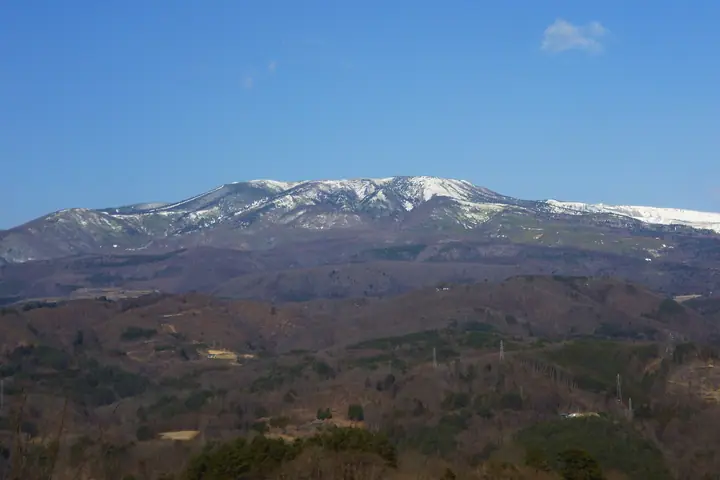
Mount Kusatsu-Shirane is an active volcano reaching 2171 m in Tsumagoi Village and Kusatsu Town, Gunma, within Joshinetsu-Kogen National Park. Its highest peak is Honshirane. Yugama, a crater lake near Shirane’s summit, is about 300 m across and among the world’s most acidic lakes. Its emerald-green water contrasts strikingly with the barren crater walls. Entry restrictions continue in response to volcanic alert levels.
Mount Kusatsu-Shirane at a glance
- Weather: The most settled day in the next 7 days is Wed, November 4: clear, gusts up to 8 m/s. Sat, Nov 7: strong wind (gusts up to 16 m/s).
Mount Kusatsu-Shirane weather (hourly, 14 days)
Sunrise today 06:11, sunset 16:48
| Tue, 11/3 | Wed, 11/4 | Thu, 11/5 | Fri, 11/6 | Sat, 11/7 | Sun, 11/8 | Mon, 11/9 | Tue, 11/10 | Wed, 11/11 | Thu, 11/12 | Fri, 11/13 | Sat, 11/14 | Sun, 11/15 | Mon, 11/16 | Tue, 11/17 | |||||||||||||||||||||||||||||||||||||||||||||||||||||||||||||||||||||||
|---|---|---|---|---|---|---|---|---|---|---|---|---|---|---|---|---|---|---|---|---|---|---|---|---|---|---|---|---|---|---|---|---|---|---|---|---|---|---|---|---|---|---|---|---|---|---|---|---|---|---|---|---|---|---|---|---|---|---|---|---|---|---|---|---|---|---|---|---|---|---|---|---|---|---|---|---|---|---|---|---|---|---|---|---|---|
| Japan time | 15 | 17 | 19 | 21 | 23 | 1 | 3 | 5 | 7 | 9 | 11 | 13 | 15 | 18 | 21 | 0 | 3 | 6 | 9 | 12 | 15 | 18 | 21 | 0 | 3 | 6 | 9 | 12 | 15 | 18 | 21 | 0 | 3 | 6 | 9 | 12 | 15 | 18 | 21 | 0 | 3 | 6 | 9 | 12 | 15 | 18 | 21 | 0 | 3 | 6 | 9 | 15 | 21 | 3 | 9 | 15 | 21 | 3 | 9 | 15 | 21 | 3 | 9 | 15 | 21 | 3 | 9 | 15 | 21 | 3 | 9 | 15 | 21 | 3 | 9 | 15 | 21 | 3 | 9 | 15 | 21 | 3 | 9 | 15 | |
  |   | |  | | | | |  |   | | | |   |   | | | |   |   | | | | |   |   | | | | | | | |   |   | | | | | | | | | | | | | |   | |   | | | | | | |   |   | | | | | | | | | | | | | |  | | | | |   | | | | | | | ||
| Temperature | °C | 2° | -1° | -4° | -5° | -4° | -4° | -4° | -3° | -2° | 4° | 6° | 7° | 5° | 1° | 0° | 1° | 2° | 3° | 6° | 10° | 9° | 5° | 6° | 5° | 4° | 3° | 8° | 10° | 9° | 3° | 1° | 0° | -1° | -3° | -1° | 1° | -1° | -4° | -5° | -6° | -5° | -5° | -2° | 1° | -1° | -4° | -4° | -3° | -2° | -2° | 1° | 2° | -2° | -2° | 0° | 0° | -3° | -4° | -5° | -4° | -4° | -5° | -1° | 1° | -6° | -3° | -2° | -3° | -5° | -7° | 1° | 4° | -4° | -2° | 3° | 6° | 1° | 2° | 6° | 2° | -4° | -5° | 0° | 2° |
| Precipitation | mm | 0.4 | 0.9 | 10 | 5 | 2.0 | 1.0 | 0.1 | 0.1 | 0.2 | 0.3 | 0.3 | 0.1 | 0.7 | 0.1 | 0.2 | 0.2 | 1.9 | 3.6 | 4.3 | 1.2 | 3.1 | 1.1 | 6 | 6 | 1.2 | 2.2 | ||||||||||||||||||||||||||||||||||||||||||||||||||||||||||
| New snow | cm | <.1 | <.1 | 0.1 | <.1 | 0.3 | 0.2 | 1.4 | 3.6 | 4.2 | 1.0 | 3.0 | 1.1 | 0.3 | |||||||||||||||||||||||||||||||||||||||||||||||||||||||||||||||||||||||
| Snow depth | cm | 0 | 0 | 0 | 0 | 0 | 0 | 0 | 0 | 0 | 0 | 0 | 0 | 0 | 0 | 0 | 0 | 0 | 0 | 0 | 0 | 0 | 0 | 0 | 0 | 0 | 0 | 0 | 0 | 0 | 0 | 0 | 0 | 0 | 0 | 0 | 0 | 0 | 0 | 0 | 0 | 0 | 0 | 0 | 0 | 0 | 0 | 0 | 0 | 0 | 0 | 0 | 0 | 0 | 0 | 0 | 0 | 0 | <1 | 3 | 6 | 6 | 6 | 6 | 4 | 4 | 4 | 6 | 6 | 5 | 5 | 5 | 4 | 4 | 4 | 3 | 2 | 1 | <1 | <1 | 0 | 0 | 0 | 0 | 0 |
| Wind | m/s | 2 | 2 | 1 | 1 | 1 | 0 | 1 | 1 | 0 | 1 | 2 | 2 | 2 | 2 | 2 | 2 | 1 | 1 | 0 | 0 | 0 | 1 | 0 | 1 | 1 | 1 | 2 | 4 | 4 | 2 | 2 | 3 | 3 | 3 | 3 | 5 | 4 | 3 | 2 | 2 | 3 | 3 | 3 | 3 | 3 | 1 | 1 | 1 | 1 | 1 | 1 | 1 | 1 | 0 | 2 | 1 | 0 | 5 | 6 | 6 | 2 | 2 | 1 | 0 | 0 | 2 | 2 | 4 | 2 | 2 | 0 | 0 | 0 | 1 | 0 | 1 | 0 | 2 | 2 | 5 | 4 | 3 | 1 | 1 |
| Wind gusts | m/s | 9 | 8 | 6 | 5 | 5 | 4 | 4 | 4 | 4 | 4 | 6 | 7 | 8 | 7 | 8 | 8 | 7 | 7 | 6 | 6 | 6 | 4 | 4 | 5 | 6 | 7 | 8 | 12 | 14 | 12 | 10 | 11 | 12 | 11 | 13 | 16 | 16 | 13 | 11 | 10 | 11 | 12 | 11 | 10 | 11 | 9 | 6 | 6 | 6 | 7 | 7 | 7 | 5 | 3 | 6 | 9 | 7 | 18 | 27 | 25 | 18 | 9 | 7 | 6 | 5 | 7 | 10 | 14 | 13 | 10 | 7 | 4 | 4 | 4 | 5 | 8 | 7 | 11 | 10 | 17 | 18 | 13 | 8 | 6 |
| Wind dir. | ↓ | ↓ | ↓ | ↓ | ↓ | ↓ | ↓ | ↓ | ↓ | ↓ | ↓ | ↓ | ↓ | ↓ | ↓ | ↓ | ↓ | ↓ | ↓ | ↓ | ↓ | ↓ | ↓ | ↓ | ↓ | ↓ | ↓ | ↓ | ↓ | ↓ | ↓ | ↓ | ↓ | ↓ | ↓ | ↓ | ↓ | ↓ | ↓ | ↓ | ↓ | ↓ | ↓ | ↓ | ↓ | ↓ | ↓ | ↓ | ↓ | ↓ | ↓ | ↓ | ↓ | ↓ | ↓ | ↓ | ↓ | ↓ | ↓ | ↓ | ↓ | ↓ | ↓ | ↓ | ↓ | ↓ | ↓ | ↓ | ↓ | ↓ | ↓ | ↓ | ↓ | ↓ | ↓ | ↓ | ↓ | ↓ | ↓ | ↓ | ↓ | ↓ | ↓ | ||
Mount Kusatsu-Shirane live cameras
Huts, campsites and lodging near Mount Kusatsu-Shirane
Mountain huts
Campsites
- 芳ヶ平野営場
Lodging
- 万座ホテルジュラク
- Manza Kogen Hotel
- 豊国館
- 万座プリンスホテル
- 湯の花旅館
Lists that include Mount Kusatsu-Shirane
100 Famous Japanese Mountains · Japan 200 Famous Mountains · Japan's 300 Famous Mountains · Kanto 100 Famous Mountains · Gunma 100 Famous Mountains · Elevations of 1003 Mountains of Japan · 1000 Mountains of Japan
Mount Kusatsu-Shirane facts
- Elevation
- 2,171 m
- Location
- Tsumagoi, Gunma / Kusatsu, Gunma
36.622950, 138.531713 - National Park
- 上信越高原国立公園
- Volcano
- Active volcano (草津白根山)
- Website
- www.town.kusatsu.gunma.jp
- Access Information
- www.town.kusatsu.gunma.jp
- Wikipedia
- ja.wikipedia.org