
Mount Kuro
黒岳
Kamikawa, Hokkaido · Elevation 1,984 m
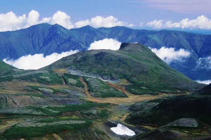
Mount Kuro is a 1,984 m peak in Kamikawa Town, Hokkaido — the gateway from the Sōunkyō ravine to the Ohachi-daira caldera at the heart of the Daisetsuzan range. Its name (Black Peak) refers to the dark slopes left when its snow melts early. The Sōunkyō Kurodake Ropeway and chair lift carry climbers to the seventh station at about 1,520 m, from where the summit is reached in roughly 1.5 hours, making it the easiest introduction to Daisetsuzan. The first-come-first-served Kurodake Ishimuro stone hut about 20 minutes beyond the summit serves as the base for traverses of Ohachi-daira, Mount Hokuchin, and Mount Asahi. The mountain lies within Daisetsuzan National Park and is one of the 100 Famous Mountains of Hokkaido.
Mount Kuro at a glance
- Weather: The most settled day in the next 7 days is Thu, November 5: cloudy, gusts up to 12 m/s. Wed, Nov 4, Sat, Nov 7, Sun, Nov 8: strong wind (gusts up to 28 m/s).
- Route: The shortest is Kurodake Fifth Station to Kurodake Ishimuro via the Summit: about 2 h 59 min, 4.0 km, about 690 m of climbing.
Mount Kuro weather (hourly, 14 days)
Sunrise today 06:06, sunset 16:18
| Tue, 11/3 | Wed, 11/4 | Thu, 11/5 | Fri, 11/6 | Sat, 11/7 | Sun, 11/8 | Mon, 11/9 | Tue, 11/10 | Wed, 11/11 | Thu, 11/12 | Fri, 11/13 | Sat, 11/14 | Sun, 11/15 | Mon, 11/16 | Tue, 11/17 | |||||||||||||||||||||||||||||||||||||||||||||||||||||||||||||||||||||||
|---|---|---|---|---|---|---|---|---|---|---|---|---|---|---|---|---|---|---|---|---|---|---|---|---|---|---|---|---|---|---|---|---|---|---|---|---|---|---|---|---|---|---|---|---|---|---|---|---|---|---|---|---|---|---|---|---|---|---|---|---|---|---|---|---|---|---|---|---|---|---|---|---|---|---|---|---|---|---|---|---|---|---|---|---|---|
| Japan time | 21 | 23 | 1 | 3 | 5 | 7 | 9 | 11 | 13 | 15 | 17 | 19 | 21 | 0 | 3 | 6 | 9 | 12 | 15 | 18 | 21 | 0 | 3 | 6 | 9 | 12 | 15 | 18 | 21 | 0 | 3 | 6 | 9 | 12 | 15 | 18 | 21 | 0 | 3 | 6 | 9 | 12 | 15 | 18 | 21 | 0 | 3 | 6 | 9 | 12 | 15 | 21 | 3 | 9 | 15 | 21 | 3 | 9 | 15 | 21 | 3 | 9 | 15 | 21 | 3 | 9 | 15 | 21 | 3 | 9 | 15 | 21 | 3 | 9 | 15 | 21 | 3 | 9 | 15 | 21 | 3 | 9 | 15 | 21 | |
  | | | | |   | | | |  |   |  | | | |   |   |   | |   | |   | | |   |   |   |   | | | | | | | | | | | | | | | | | | | | | | | | | |   | | | | | | | | | | | | | | |  | | | | | | | | | | | | |   | | | ||
| Temperature | °C | -12° | -12° | -13° | -11° | -11° | -10° | -9° | -9° | -8° | -8° | -14° | -15° | -14° | -12° | -12° | -12° | -3° | 0° | -1° | -3° | -3° | -2° | -2° | -2° | -2° | -1° | 0° | -3° | -7° | -11° | -13° | -14° | -13° | -13° | -13° | -14° | -13° | -13° | -12° | -12° | -12° | -11° | -12° | -14° | -14° | -15° | -16° | -16° | -14° | -12° | -14° | -19° | -17° | -12° | -11° | -17° | -15° | -10° | -8° | -17° | -18° | -10° | -9° | -14° | -15° | -15° | -13° | -15° | -18° | -11° | -8° | -13° | -10° | -3° | -2° | -3° | -3° | -4° | -9° | -12° | -13° | -12° | -10° | -16° |
| Precipitation | mm | 0.8 | 1.6 | 1.4 | 0.9 | 1.1 | 0.7 | 0.2 | 0.1 | 1.3 | 2.2 | 4.8 | 2.3 | 0.2 | 2.2 | 2.2 | 1.3 | 0.7 | 0.5 | 1.8 | 3.1 | 2.2 | 1.5 | 2.5 | 4.5 | 4.3 | 3.2 | 2.4 | 1.6 | 1.3 | 0.6 | 0.2 | 0.3 | 0.7 | 0.3 | 0.2 | 0.8 | 0.8 | 0.7 | 0.5 | 0.9 | 1.6 | 0.1 | 1.4 | 0.4 | 0.8 | 2.0 | 1.5 | 1.2 | 0.2 | 0.6 | 2.6 | 2.3 | 2.0 | 3.3 | 2.6 | 1.0 | 0.2 | |||||||||||||||||||||||||||
| New snow | cm | <.1 | <.1 | 0.8 | 1.6 | 1.3 | 0.9 | 1.1 | 0.7 | 0.2 | 0.3 | 0.8 | 2.0 | 1.3 | 0.7 | 0.5 | 1.8 | 3.1 | 2.2 | 1.5 | 2.5 | 4.4 | 4.2 | 3.1 | 2.4 | 1.6 | 1.2 | 0.6 | 0.1 | 0.3 | 0.5 | 0.3 | 0.2 | 0.8 | 0.7 | 0.7 | 0.4 | <.1 | 0.9 | 1.6 | 0.1 | 1.4 | 0.4 | 0.8 | 2.0 | 1.5 | 1.2 | 0.4 | 0.9 | 1.6 | 3.3 | 2.5 | 0.9 | 0.2 | |||||||||||||||||||||||||||||||
| Snow depth | cm | 32 | 31 | 32 | 33 | 34 | 35 | 35 | 36 | 35 | 35 | 35 | 35 | 35 | 34 | 34 | 34 | 34 | 33 | 32 | 32 | 32 | 32 | 31 | 31 | 30 | 28 | 27 | 27 | 28 | 29 | 30 | 30 | 31 | 34 | 35 | 35 | 35 | 36 | 38 | 40 | 43 | 46 | 47 | 48 | 48 | 47 | 47 | 47 | 46 | 46 | 46 | 46 | 46 | 46 | 45 | 44 | 45 | 46 | 45 | 44 | 44 | 43 | 44 | 44 | 45 | 47 | 48 | 48 | 48 | 47 | 46 | 46 | 45 | 45 | 44 | 43 | 43 | 44 | 46 | 48 | 48 | 48 | 47 | 47 |
| Wind | m/s | 3 | 2 | 1 | 2 | 3 | 4 | 4 | 3 | 3 | 1 | 1 | 1 | 2 | 2 | 2 | 1 | 2 | 3 | 1 | 1 | 1 | 1 | 0 | 1 | 1 | 1 | 2 | 4 | 5 | 6 | 6 | 5 | 5 | 6 | 8 | 9 | 8 | 8 | 7 | 6 | 5 | 5 | 4 | 4 | 3 | 2 | 2 | 2 | 2 | 2 | 2 | 1 | 1 | 1 | 0 | 1 | 1 | 2 | 1 | 1 | 1 | 2 | 2 | 1 | 2 | 4 | 4 | 3 | 2 | 2 | 1 | 1 | 1 | 2 | 2 | 2 | 2 | 1 | 3 | 3 | 3 | 2 | 1 | 1 |
| Wind gusts | m/s | 12 | 12 | 11 | 11 | 14 | 17 | 17 | 16 | 14 | 13 | 10 | 9 | 10 | 11 | 10 | 10 | 10 | 12 | 12 | 8 | 7 | 5 | 6 | 7 | 7 | 7 | 10 | 14 | 20 | 21 | 23 | 23 | 22 | 25 | 28 | 29 | 29 | 28 | 28 | 25 | 23 | 20 | 18 | 16 | 14 | 12 | 9 | 9 | 9 | 10 | 10 | 8 | 7 | 6 | 7 | 6 | 6 | 8 | 8 | 5 | 6 | 8 | 9 | 10 | 10 | 14 | 17 | 18 | 13 | 10 | 8 | 7 | 8 | 12 | 13 | 13 | 11 | 9 | 9 | 12 | 13 | 12 | 8 | 5 |
| Wind dir. | ↓ | ↓ | ↓ | ↓ | ↓ | ↓ | ↓ | ↓ | ↓ | ↓ | ↓ | ↓ | ↓ | ↓ | ↓ | ↓ | ↓ | ↓ | ↓ | ↓ | ↓ | ↓ | ↓ | ↓ | ↓ | ↓ | ↓ | ↓ | ↓ | ↓ | ↓ | ↓ | ↓ | ↓ | ↓ | ↓ | ↓ | ↓ | ↓ | ↓ | ↓ | ↓ | ↓ | ↓ | ↓ | ↓ | ↓ | ↓ | ↓ | ↓ | ↓ | ↓ | ↓ | ↓ | ↓ | ↓ | ↓ | ↓ | ↓ | ↓ | ↓ | ↓ | ↓ | ↓ | ↓ | ↓ | ↓ | ↓ | ↓ | ↓ | ↓ | ↓ | ↓ | ↓ | ↓ | ↓ | ↓ | ↓ | ↓ | ↓ | ↓ | ↓ | ↓ | ↓ | |
Mount Kuro hiking routes
- Kurodake Fifth Station to Kurodake Ishimuro via the Summit 4.0 km · Ascent 691 m Ropeway Kurodake Station (Aerialway station)
- Daisetsuzan Ohachidaira Circuit and Mount Hokuchin from Kurodake Seventh Station 16.0 km · Ascent 1,231 m 七合目リフト駅 (Aerialway station)
Hiking times are estimates calculated from the terrain.
Huts, campsites and lodging near Mount Kuro
Mountain huts
Campsites
- Kurodake Camp Site
- Hakuun Camp Site
Lodging
- Sounkyo Onsen Yumoto Ginsenkaku
- Resort Pension Yamanoue
- Onsen Pension Ginga
- Guesthouse Todate
- ホテル大雪
Lists that include Mount Kuro
Hokkaido 100 Famous Mountains · Elevations of 1003 Mountains of Japan · 1000 Mountains of Japan
Mount Kuro facts
- Elevation
- 1,984 m
- Location
- Kamikawa, Hokkaido
43.697549, 142.920263 - National Park
- 大雪山国立公園
- Website
- www.rinyu.co.jp
- Trail Map
- www.daisetsuzan.or.jp (PDF)
- Access Information
- www.rinyu.co.jp
- Wikipedia
- en.wikipedia.org