
Mount Hokuchin
北鎮岳
Higashikawa, Hokkaido · Elevation 2,244 m
Mount Hokuchin is a 2,244 m peak on the border of Kamikawa and Higashikawa towns in central Hokkaido — the second-highest summit in Hokkaido after Mount Asahi and the high point of the rim of the Ohachi-daira caldera in the central Daisetsuzan massif. From the 7th station of the Kurodake Ropeway in Sōunkyō, the traverse over Kurodake, Hokkaidake, and Ryōundake reaches the summit in about 3 hours 40 minutes. A vast snow patch on the northern flank persists through summer, and on clear days the view extends to Mount Asahi, Mount Tomuraushi, and the Tokachi range. The mountain lies within Daisetsuzan National Park and is one of the 100 Famous Mountains of Hokkaido.
Mount Hokuchin at a glance
- Weather: The most settled day in the next 7 days is Thu, November 5: clear, gusts up to 11 m/s. Wed, Nov 4, Sat, Nov 7, Sun, Nov 8: strong wind (gusts up to 24 m/s).
- Route: The shortest is Daisetsuzan Ohachidaira Circuit and Mount Hokuchin from Kurodake Seventh Station: about 9 h 32 min, 16.0 km, about 1,230 m of climbing.
Mount Hokuchin weather (hourly, 14 days)
Sunrise today 06:06, sunset 16:18
| Tue, 11/3 | Wed, 11/4 | Thu, 11/5 | Fri, 11/6 | Sat, 11/7 | Sun, 11/8 | Mon, 11/9 | Tue, 11/10 | Wed, 11/11 | Thu, 11/12 | Fri, 11/13 | Sat, 11/14 | Sun, 11/15 | Mon, 11/16 | Tue, 11/17 | |||||||||||||||||||||||||||||||||||||||||||||||||||||||||||||||||||||||
|---|---|---|---|---|---|---|---|---|---|---|---|---|---|---|---|---|---|---|---|---|---|---|---|---|---|---|---|---|---|---|---|---|---|---|---|---|---|---|---|---|---|---|---|---|---|---|---|---|---|---|---|---|---|---|---|---|---|---|---|---|---|---|---|---|---|---|---|---|---|---|---|---|---|---|---|---|---|---|---|---|---|---|---|---|---|
| Japan time | 15 | 17 | 19 | 21 | 23 | 1 | 3 | 5 | 7 | 9 | 11 | 13 | 15 | 18 | 21 | 0 | 3 | 6 | 9 | 12 | 15 | 18 | 21 | 0 | 3 | 6 | 9 | 12 | 15 | 18 | 21 | 0 | 3 | 6 | 9 | 12 | 15 | 18 | 21 | 0 | 3 | 6 | 9 | 12 | 15 | 18 | 21 | 0 | 3 | 6 | 9 | 15 | 21 | 3 | 9 | 15 | 21 | 3 | 9 | 15 | 21 | 3 | 9 | 15 | 21 | 3 | 9 | 15 | 21 | 3 | 9 | 15 | 21 | 3 | 9 | 15 | 21 | 3 | 9 | 15 | 21 | 3 | 9 | 15 | |
  |   | |   | | | | | | | | |   |  | |   | | |   | | | |   | | | |   | |   |   | | | | | | | | | | | | | | | | | | | | | | | | |   |  |   | | | | | | | | | | | | |  | | | | | | | | |   | | | | | | ||
| Temperature | °C | -10° | -12° | -12° | -13° | -12° | -12° | -10° | -10° | -10° | -10° | -9° | -8° | -8° | -14° | -12° | -11° | -10° | -10° | -3° | 0° | -1° | -3° | -2° | -2° | -2° | -2° | 0° | 1° | 0° | -4° | -7° | -10° | -13° | -14° | -13° | -13° | -13° | -14° | -14° | -14° | -15° | -15° | -13° | -12° | -12° | -13° | -13° | -14° | -14° | -14° | -14° | -13° | -19° | -17° | -13° | -12° | -18° | -15° | -10° | -9° | -16° | -16° | -10° | -10° | -14° | -15° | -16° | -13° | -15° | -18° | -11° | -9° | -12° | -10° | -3° | -3° | -3° | -3° | -5° | -9° | -12° | -13° | -12° | -11° |
| Precipitation | mm | 0.5 | 0.6 | 0.4 | 1.1 | 0.9 | 1.0 | 0.6 | 0.8 | 0.2 | 0.5 | 1.0 | 2.8 | 2.8 | 3.2 | 0.9 | 0.1 | 3.3 | 2.3 | 2.0 | 0.7 | 0.4 | 1.8 | 3.5 | 1.3 | 0.4 | 0.4 | 0.9 | 1.9 | 1.8 | 3.3 | 3.1 | 1.8 | 1.5 | 0.6 | 0.2 | 0.2 | 0.2 | 1.2 | 1.1 | 0.9 | 0.8 | 1.4 | 0.2 | 1.6 | 0.5 | 1.5 | 2.3 | 1.6 | 1.5 | 0.1 | 0.4 | 1.8 | 1.7 | 2.7 | 3.8 | 3.7 | 1.4 | 0.2 | ||||||||||||||||||||||||||
| New snow | cm | 0.5 | 0.6 | <.1 | <.1 | 0.4 | 1.1 | 0.8 | 1.0 | 0.6 | 0.8 | 0.2 | 0.9 | 2.0 | 2.0 | 0.7 | 0.4 | 1.8 | 3.5 | 1.3 | 0.4 | 0.4 | 0.9 | 1.9 | 1.8 | 3.3 | 3.1 | 1.8 | 1.5 | 0.5 | 0.2 | 0.1 | 0.1 | <.1 | 1.2 | 1.1 | 0.8 | <.1 | 0.8 | 1.4 | 0.2 | 1.5 | 0.5 | 1.4 | 2.3 | 1.6 | 1.5 | <.1 | 0.1 | 1.8 | 3.8 | 3.6 | 1.2 | 0.2 | |||||||||||||||||||||||||||||||
| Snow depth | cm | 29 | 30 | 30 | 30 | 29 | 30 | 31 | 32 | 32 | 32 | 33 | 33 | 32 | 32 | 32 | 32 | 32 | 31 | 31 | 30 | 29 | 29 | 29 | 28 | 28 | 27 | 26 | 24 | 22 | 23 | 23 | 25 | 25 | 25 | 27 | 31 | 31 | 32 | 32 | 33 | 34 | 36 | 39 | 41 | 43 | 43 | 43 | 43 | 43 | 43 | 42 | 42 | 43 | 43 | 43 | 42 | 41 | 42 | 43 | 42 | 41 | 40 | 40 | 41 | 41 | 42 | 44 | 46 | 47 | 46 | 45 | 44 | 44 | 43 | 43 | 41 | 39 | 39 | 39 | 42 | 45 | 46 | 45 | 45 |
| Wind | m/s | 3 | 2 | 2 | 2 | 1 | 2 | 3 | 5 | 5 | 5 | 4 | 3 | 2 | 1 | 1 | 1 | 2 | 1 | 2 | 2 | 1 | 1 | 1 | 1 | 1 | 1 | 2 | 2 | 3 | 4 | 5 | 6 | 6 | 5 | 5 | 6 | 7 | 8 | 8 | 7 | 7 | 6 | 6 | 6 | 6 | 4 | 3 | 2 | 3 | 2 | 1 | 2 | 1 | 0 | 1 | 0 | 1 | 2 | 1 | 1 | 0 | 0 | 2 | 3 | 2 | 2 | 4 | 4 | 2 | 1 | 1 | 0 | 1 | 1 | 3 | 4 | 3 | 2 | 1 | 2 | 3 | 3 | 1 | 1 |
| Wind gusts | m/s | 15 | 11 | 9 | 10 | 11 | 11 | 13 | 18 | 20 | 18 | 17 | 14 | 12 | 9 | 9 | 10 | 10 | 10 | 9 | 11 | 10 | 7 | 6 | 6 | 5 | 7 | 11 | 11 | 14 | 18 | 20 | 22 | 23 | 22 | 21 | 23 | 24 | 25 | 26 | 25 | 23 | 23 | 22 | 22 | 22 | 19 | 14 | 13 | 10 | 10 | 8 | 9 | 8 | 7 | 5 | 6 | 5 | 6 | 7 | 6 | 4 | 5 | 8 | 11 | 12 | 10 | 14 | 16 | 16 | 11 | 8 | 6 | 5 | 6 | 13 | 14 | 14 | 12 | 9 | 8 | 12 | 13 | 12 | 7 |
| Wind dir. | ↓ | ↓ | ↓ | ↓ | ↓ | ↓ | ↓ | ↓ | ↓ | ↓ | ↓ | ↓ | ↓ | ↓ | ↓ | ↓ | ↓ | ↓ | ↓ | ↓ | ↓ | ↓ | ↓ | ↓ | ↓ | ↓ | ↓ | ↓ | ↓ | ↓ | ↓ | ↓ | ↓ | ↓ | ↓ | ↓ | ↓ | ↓ | ↓ | ↓ | ↓ | ↓ | ↓ | ↓ | ↓ | ↓ | ↓ | ↓ | ↓ | ↓ | ↓ | ↓ | ↓ | ↓ | ↓ | ↓ | ↓ | ↓ | ↓ | ↓ | ↓ | ↓ | ↓ | ↓ | ↓ | ↓ | ↓ | ↓ | ↓ | ↓ | ↓ | ↓ | ↓ | ↓ | ↓ | ↓ | ↓ | ↓ | ↓ | ↓ | ↓ | ↓ | ↓ | ↓ | |
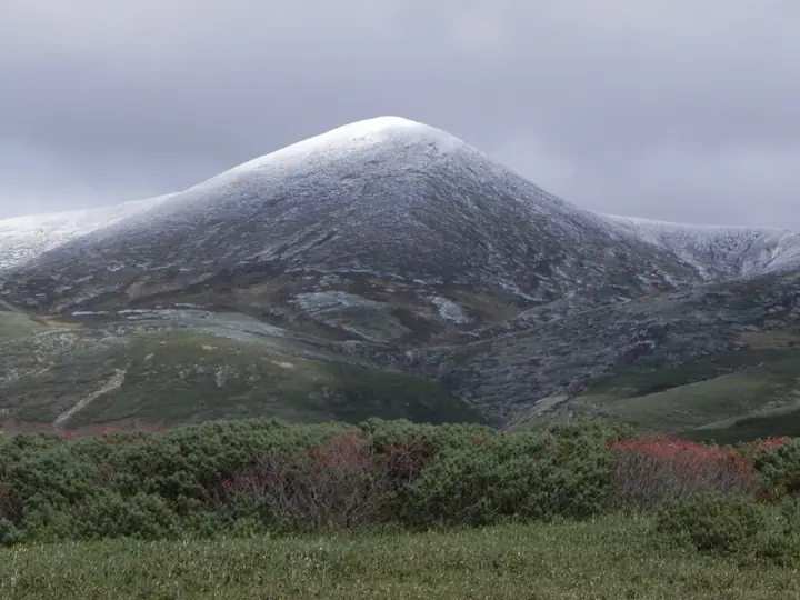
Mount Hokuchin hiking routes
Hiking times are estimates calculated from the terrain.
Huts, campsites and lodging near Mount Hokuchin
Mountain huts
Campsites
- Kurodake Camp Site
- Ura-Asahi Camp Site
- Hakuun Camp Site
Lists that include Mount Hokuchin
Hokkaido 100 Famous Mountains · Elevations of 1003 Mountains of Japan · 1000 Mountains of Japan
Mount Hokuchin facts
- Elevation
- 2,244 m
- Location
- Higashikawa, Hokkaido
43.692790, 142.879885 - National Park
- 大雪山国立公園
- Website
- www.daisetsuzan.or.jp
- Trail Map
- www.daisetsuzan.or.jp (PDF)
- Access Information
- www.rinyu.co.jp
- Wikipedia
- ja.wikipedia.org