
Mount Hakuun
白雲岳
Biei, Hokkaido · Elevation 2,230 m
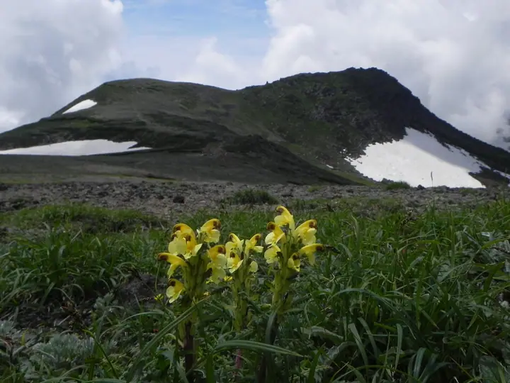
Mount Hakuun is a 2,230 m peak at the meeting point of Kamikawa, Biei, and Shintoku municipalities in central Hokkaido, commanding sweeping views of the Daisetsu massif. It is a key waypoint on traverses from Ginsendai, Mount Midori, or Mount Asahi, and the 'zebra' striped snow pattern on its north-eastern slopes is a celebrated early-summer sight. The Hakuun emergency shelter stands just below the summit, and the surrounding ridges support iconic Daisetsuzan alpine flora such as Lagotis glauca and Dryas octopetala. The mountain lies within Daisetsuzan National Park and is one of the 100 Famous Mountains of Hokkaido.
Mount Hakuun at a glance
- Weather: The most settled day in the next 7 days is Thu, November 5: clear, gusts up to 11 m/s. Wed, Nov 4, Sat, Nov 7, Sun, Nov 8: strong wind (gusts up to 28 m/s).
- Route: The shortest is Mount Hakuun from Ginsendai via Akadake and Koizumidake: about 7 h 37 min, 13.3 km, about 870 m of climbing.
Mount Hakuun weather (hourly, 14 days)
Sunrise today 06:06, sunset 16:18
| Tue, 11/3 | Wed, 11/4 | Thu, 11/5 | Fri, 11/6 | Sat, 11/7 | Sun, 11/8 | Mon, 11/9 | Tue, 11/10 | Wed, 11/11 | Thu, 11/12 | Fri, 11/13 | Sat, 11/14 | Sun, 11/15 | Mon, 11/16 | Tue, 11/17 | |||||||||||||||||||||||||||||||||||||||||||||||||||||||||||||||||||||||
|---|---|---|---|---|---|---|---|---|---|---|---|---|---|---|---|---|---|---|---|---|---|---|---|---|---|---|---|---|---|---|---|---|---|---|---|---|---|---|---|---|---|---|---|---|---|---|---|---|---|---|---|---|---|---|---|---|---|---|---|---|---|---|---|---|---|---|---|---|---|---|---|---|---|---|---|---|---|---|---|---|---|---|---|---|---|
| Japan time | 15 | 17 | 19 | 21 | 23 | 1 | 3 | 5 | 7 | 9 | 11 | 13 | 15 | 18 | 21 | 0 | 3 | 6 | 9 | 12 | 15 | 18 | 21 | 0 | 3 | 6 | 9 | 12 | 15 | 18 | 21 | 0 | 3 | 6 | 9 | 12 | 15 | 18 | 21 | 0 | 3 | 6 | 9 | 12 | 15 | 18 | 21 | 0 | 3 | 6 | 9 | 15 | 21 | 3 | 9 | 15 | 21 | 3 | 9 | 15 | 21 | 3 | 9 | 15 | 21 | 3 | 9 | 15 | 21 | 3 | 9 | 15 | 21 | 3 | 9 | 15 | 21 | 3 | 9 | 15 | 21 | 3 | 9 | 15 | |
  |   | |   | | | | | | | | |   |  | |   | | |   | | | |   | | | |   | |   |   | | | | | | | | | | | | | | | | | | | | |   | | | |   |  |   | | | | | | | | | | | | |  | | | | | | | | |   | | | | | | ||
| Temperature | °C | -12° | -13° | -14° | -14° | -14° | -14° | -13° | -12° | -12° | -11° | -10° | -10° | -10° | -16° | -15° | -15° | -13° | -13° | -4° | -1° | -2° | -5° | -3° | -3° | -3° | -3° | -1° | -1° | -2° | -5° | -9° | -12° | -15° | -15° | -14° | -15° | -15° | -15° | -15° | -16° | -16° | -16° | -14° | -14° | -14° | -15° | -15° | -16° | -16° | -17° | -15° | -14° | -21° | -19° | -14° | -13° | -18° | -17° | -12° | -10° | -19° | -19° | -12° | -11° | -15° | -16° | -17° | -15° | -16° | -20° | -12° | -10° | -14° | -12° | -5° | -4° | -4° | -5° | -5° | -10° | -14° | -14° | -13° | -11° |
| Precipitation | mm | 0.4 | 0.4 | 0.5 | 1.3 | 1.2 | 1.0 | 0.8 | 0.8 | 0.1 | 0.2 | 1.0 | 2.5 | 2.7 | 3.8 | 1.4 | 0.1 | 2.0 | 2.0 | 1.8 | 0.7 | 0.5 | 1.7 | 3.0 | 1.2 | 0.3 | 0.5 | 1.0 | 1.9 | 2.1 | 3.2 | 3.3 | 2.1 | 1.4 | 0.4 | 0.1 | 0.1 | 0.7 | 0.7 | 0.5 | 0.9 | 1.6 | 0.1 | 1.4 | 0.4 | 0.8 | 2.0 | 1.5 | 1.2 | 0.2 | 0.6 | 2.6 | 2.3 | 2.0 | 3.3 | 2.6 | 1.0 | 0.2 | |||||||||||||||||||||||||||
| New snow | cm | 0.4 | 0.4 | <.1 | <.1 | 0.4 | 1.3 | 1.2 | 1.0 | 0.7 | 0.8 | 0.1 | 0.9 | 1.9 | 1.8 | 0.7 | 0.5 | 1.7 | 3.0 | 1.1 | 0.3 | 0.5 | 0.9 | 1.9 | 2.1 | 3.2 | 3.3 | 2.1 | 1.4 | 0.4 | 0.1 | <.1 | <.1 | <.1 | 0.7 | 0.7 | 0.4 | <.1 | 0.9 | 1.6 | 0.1 | 1.4 | 0.4 | 0.8 | 2.0 | 1.5 | 1.2 | 0.4 | 0.9 | 1.6 | 3.3 | 2.5 | 0.9 | 0.2 | |||||||||||||||||||||||||||||||
| Snow depth | cm | 32 | 32 | 32 | 32 | 31 | 32 | 33 | 34 | 35 | 35 | 36 | 35 | 35 | 35 | 35 | 34 | 34 | 34 | 34 | 33 | 32 | 32 | 32 | 32 | 31 | 31 | 30 | 28 | 27 | 27 | 28 | 29 | 30 | 30 | 31 | 34 | 35 | 35 | 35 | 36 | 38 | 40 | 43 | 46 | 47 | 48 | 48 | 47 | 47 | 47 | 46 | 46 | 46 | 46 | 46 | 45 | 44 | 45 | 46 | 45 | 44 | 44 | 43 | 44 | 44 | 45 | 47 | 48 | 48 | 48 | 47 | 46 | 46 | 45 | 45 | 44 | 43 | 43 | 44 | 46 | 48 | 48 | 48 | 47 |
| Wind | m/s | 3 | 2 | 2 | 2 | 2 | 2 | 2 | 3 | 4 | 4 | 4 | 3 | 2 | 1 | 2 | 2 | 2 | 1 | 2 | 2 | 1 | 1 | 1 | 1 | 0 | 1 | 2 | 2 | 2 | 4 | 5 | 5 | 6 | 4 | 5 | 7 | 8 | 8 | 7 | 7 | 7 | 6 | 6 | 5 | 5 | 4 | 4 | 3 | 3 | 2 | 1 | 2 | 1 | 1 | 1 | 0 | 1 | 1 | 2 | 1 | 1 | 1 | 2 | 2 | 1 | 2 | 4 | 4 | 3 | 2 | 2 | 1 | 1 | 1 | 2 | 2 | 2 | 2 | 1 | 3 | 3 | 3 | 2 | 1 |
| Wind gusts | m/s | 15 | 11 | 10 | 11 | 12 | 11 | 13 | 15 | 18 | 18 | 17 | 15 | 14 | 10 | 10 | 11 | 11 | 10 | 9 | 11 | 11 | 8 | 7 | 7 | 6 | 7 | 11 | 11 | 14 | 16 | 18 | 20 | 23 | 22 | 20 | 25 | 28 | 29 | 28 | 26 | 25 | 26 | 23 | 22 | 20 | 18 | 16 | 15 | 12 | 11 | 8 | 9 | 8 | 7 | 6 | 7 | 6 | 6 | 8 | 8 | 5 | 6 | 8 | 9 | 10 | 10 | 14 | 17 | 18 | 13 | 10 | 8 | 7 | 8 | 12 | 13 | 13 | 11 | 9 | 9 | 12 | 13 | 12 | 8 |
| Wind dir. | ↓ | ↓ | ↓ | ↓ | ↓ | ↓ | ↓ | ↓ | ↓ | ↓ | ↓ | ↓ | ↓ | ↓ | ↓ | ↓ | ↓ | ↓ | ↓ | ↓ | ↓ | ↓ | ↓ | ↓ | ↓ | ↓ | ↓ | ↓ | ↓ | ↓ | ↓ | ↓ | ↓ | ↓ | ↓ | ↓ | ↓ | ↓ | ↓ | ↓ | ↓ | ↓ | ↓ | ↓ | ↓ | ↓ | ↓ | ↓ | ↓ | ↓ | ↓ | ↓ | ↓ | ↓ | ↓ | ↓ | ↓ | ↓ | ↓ | ↓ | ↓ | ↓ | ↓ | ↓ | ↓ | ↓ | ↓ | ↓ | ↓ | ↓ | ↓ | ↓ | ↓ | ↓ | ↓ | ↓ | ↓ | ↓ | ↓ | ↓ | ↓ | ↓ | ↓ | ↓ | |
Mount Hakuun hiking routes
Hiking times are estimates calculated from the terrain.
Huts, campsites and lodging near Mount Hakuun
Mountain huts
Campsites
- Hakuun Camp Site
- Ura-Asahi Camp Site
- Kurodake Camp Site
Lodging
- Daisetsu Kogen Sanso
Lists that include Mount Hakuun
100 Famous Hot Spring Mountains · Hokkaido 100 Famous Mountains · Elevations of 1003 Mountains of Japan · 1000 Mountains of Japan
Mount Hakuun facts
- Elevation
- 2,230 m
- Location
- Biei, Hokkaido
43.661205, 142.905918 - National Park
- 大雪山国立公園
- Website
- www.daisetsuzan.or.jp
- Trail Map
- www.daisetsuzan.or.jp (PDF)
- Access Information
- www.town.hokkaido-kamikawa.lg.jp
- Wikipedia
- ja.wikipedia.org