
Mount Izumi
泉ヶ岳
Sendai, Miyagi · Elevation 1,172 m
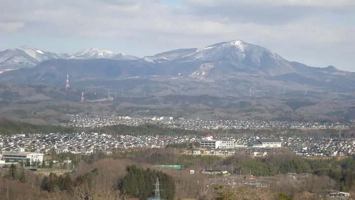
Mount Izumi is a 1,172.1 m peak rising in the northwestern part of Izumi Ward, Sendai City, Miyagi Prefecture, at the southern end of the Funagata Range and roughly an hour by car from central Sendai. Listed in the Nihon Sanbyaku Meizan, the Tōhoku 100 Meizan, the Nihon Hyakuteizan, and Sendai's Top 100 Greenery Sites, it serves as the city's home mountain. The Ōens Izumigatake Nature Interaction Hall — operated under designated-manager arrangement with Sendai City — provides hiking information and free trail maps from the foot of the mountain, alongside campgrounds and a ski resort. Four trails climb the south face (Suijin, Kakkō, Kamoshika, and Omote courses), each a 2–2.5-hour round trip well-suited to families and school excursions, and the summit ridge gives a sweeping view across the Sendai Plain to the Zaō Range and the Ōu mountains.
Mount Izumi at a glance
- Weather: The most settled day in the next 7 days is Wed, November 4: clear, gusts up to 8 m/s. Fri, Nov 6, Sat, Nov 7, Sun, Nov 8: strong wind (gusts up to 19 m/s).
- Route: The shortest is Mount Izumigatake Sliding Course and Mizugami Course Loop: about 4 h 11 min, 7.1 km, about 650 m of climbing.
Mount Izumi weather (hourly, 14 days)
Sunrise today 06:05, sunset 16:37
| Tue, 11/3 | Wed, 11/4 | Thu, 11/5 | Fri, 11/6 | Sat, 11/7 | Sun, 11/8 | Mon, 11/9 | Tue, 11/10 | Wed, 11/11 | Thu, 11/12 | Fri, 11/13 | Sat, 11/14 | Sun, 11/15 | Mon, 11/16 | Tue, 11/17 | |||||||||||||||||||||||||||||||||||||||||||||||||||||||||||||||||||||||
|---|---|---|---|---|---|---|---|---|---|---|---|---|---|---|---|---|---|---|---|---|---|---|---|---|---|---|---|---|---|---|---|---|---|---|---|---|---|---|---|---|---|---|---|---|---|---|---|---|---|---|---|---|---|---|---|---|---|---|---|---|---|---|---|---|---|---|---|---|---|---|---|---|---|---|---|---|---|---|---|---|---|---|---|---|---|
| Japan time | 21 | 23 | 1 | 3 | 5 | 7 | 9 | 11 | 13 | 15 | 17 | 19 | 21 | 0 | 3 | 6 | 9 | 12 | 15 | 18 | 21 | 0 | 3 | 6 | 9 | 12 | 15 | 18 | 21 | 0 | 3 | 6 | 9 | 12 | 15 | 18 | 21 | 0 | 3 | 6 | 9 | 12 | 15 | 18 | 21 | 0 | 3 | 6 | 9 | 12 | 15 | 21 | 3 | 9 | 15 | 21 | 3 | 9 | 15 | 21 | 3 | 9 | 15 | 21 | 3 | 9 | 15 | 21 | 3 | 9 | 15 | 21 | 3 | 9 | 15 | 21 | 3 | 9 | 15 | 21 | 3 | 9 | 15 | 21 | |
 | | | |   |   | | | |   | | | |   |   | |   | | | | | | | |   |   | |   | | | | | |   | |   |   | | |   | | | | | |   | | | | | |   | |  | | | | | | | | | | | | | | | | | |  | | | | | | | | | | | | | ||
| Temperature | °C | 0° | -1° | -1° | -1° | -1° | 2° | 7° | 9° | 10° | 9° | 4° | 3° | 4° | 4° | 4° | 5° | 5° | 7° | 7° | 7° | 7° | 7° | 6° | 6° | 9° | 12° | 11° | 6° | 4° | 1° | 0° | 0° | 0° | 0° | -1° | -2° | -2° | -2° | -2° | -2° | 1° | 2° | 2° | 0° | -1° | 0° | -2° | -2° | -1° | 2° | 1° | -2° | -3° | 0° | 2° | -1° | -1° | 0° | 4° | -1° | -1° | 2° | 3° | 0° | 1° | 1° | 1° | -1° | -3° | 1° | 5° | -2° | -2° | 4° | 7° | 4° | 3° | 7° | 4° | -2° | -2° | 1° | 3° | -2° |
| Precipitation | mm | 3.3 | 12 | 7 | 3.2 | 3.2 | 3.6 | 0.6 | 0.4 | 0.9 | 2.2 | 0.3 | 0.6 | 0.2 | 0.4 | 0.2 | 1.2 | 1.3 | 1.0 | 1.3 | 1.3 | 0.9 | 0.7 | 0.7 | 0.6 | 0.3 | 0.1 | 0.4 | 1.3 | 1.1 | 0.2 | 0.2 | 2.2 | 2.3 | 0.2 | 1.0 | 0.6 | 1.1 | 6 | 0.4 | 1.3 | 1.0 | |||||||||||||||||||||||||||||||||||||||||||
| New snow | cm | <.1 | <.1 | <.1 | 0.1 | 0.1 | <.1 | <.1 | <.1 | 0.2 | 0.1 | 0.2 | 0.2 | ||||||||||||||||||||||||||||||||||||||||||||||||||||||||||||||||||||||||
| Snow depth | cm | 0 | 0 | 0 | 0 | 0 | 0 | 0 | 0 | 0 | 0 | 0 | 0 | 0 | 0 | 0 | 0 | 0 | 0 | 0 | 0 | 0 | 0 | 0 | 0 | 0 | 0 | 0 | 0 | 0 | 0 | 0 | 0 | 0 | 0 | <1 | <1 | <1 | <1 | <1 | <1 | 0 | 0 | 0 | 0 | 0 | 0 | 0 | 0 | 0 | 0 | 0 | 0 | 0 | 0 | 0 | 0 | <1 | 0 | 0 | 0 | 0 | 0 | 0 | 0 | 0 | 0 | 0 | 0 | 0 | 0 | 0 | 0 | 0 | 0 | 0 | 0 | 0 | 0 | 0 | 0 | 0 | 0 | 0 | 0 |
| Wind | m/s | 2 | 2 | 2 | 2 | 3 | 2 | 2 | 3 | 2 | 2 | 2 | 2 | 3 | 2 | 2 | 1 | 1 | 2 | 2 | 2 | 1 | 2 | 2 | 3 | 2 | 4 | 5 | 6 | 5 | 6 | 6 | 5 | 4 | 5 | 5 | 5 | 5 | 5 | 7 | 7 | 8 | 7 | 6 | 3 | 1 | 1 | 2 | 2 | 0 | 1 | 2 | 3 | 3 | 2 | 4 | 2 | 3 | 4 | 6 | 4 | 2 | 2 | 2 | 2 | 1 | 5 | 7 | 4 | 2 | 1 | 0 | 1 | 1 | 1 | 1 | 1 | 1 | 2 | 5 | 6 | 5 | 4 | 3 | 2 |
| Wind gusts | m/s | 6 | 7 | 6 | 6 | 7 | 7 | 7 | 8 | 7 | 6 | 8 | 6 | 7 | 7 | 7 | 6 | 5 | 7 | 7 | 5 | 4 | 4 | 6 | 7 | 7 | 13 | 16 | 16 | 15 | 15 | 16 | 16 | 15 | 17 | 17 | 15 | 14 | 14 | 17 | 19 | 19 | 19 | 17 | 15 | 8 | 5 | 6 | 6 | 6 | 4 | 5 | 9 | 8 | 7 | 10 | 10 | 8 | 13 | 20 | 15 | 9 | 7 | 8 | 7 | 6 | 12 | 18 | 17 | 11 | 7 | 6 | 4 | 3 | 4 | 5 | 6 | 4 | 7 | 13 | 21 | 17 | 13 | 10 | 7 |
| Wind dir. | ↓ | ↓ | ↓ | ↓ | ↓ | ↓ | ↓ | ↓ | ↓ | ↓ | ↓ | ↓ | ↓ | ↓ | ↓ | ↓ | ↓ | ↓ | ↓ | ↓ | ↓ | ↓ | ↓ | ↓ | ↓ | ↓ | ↓ | ↓ | ↓ | ↓ | ↓ | ↓ | ↓ | ↓ | ↓ | ↓ | ↓ | ↓ | ↓ | ↓ | ↓ | ↓ | ↓ | ↓ | ↓ | ↓ | ↓ | ↓ | ↓ | ↓ | ↓ | ↓ | ↓ | ↓ | ↓ | ↓ | ↓ | ↓ | ↓ | ↓ | ↓ | ↓ | ↓ | ↓ | ↓ | ↓ | ↓ | ↓ | ↓ | ↓ | ↓ | ↓ | ↓ | ↓ | ↓ | ↓ | ↓ | ↓ | ↓ | ↓ | ↓ | ↓ | ↓ | ↓ | |
Mount Izumi hiking routes
- Mount Izumigatake Sliding Course and Mizugami Course Loop 7.1 km · Ascent 645 m Izumigatake Shōnen Shizen no Ie (Bus stop) (parking)
- Mount Izumigatake Ski-Run, Mizugami, and Kamoshika Circuit 6.8 km · Ascent 666 m Izumigatake Shōnen Shizen no Ie (Bus stop) (parking) → 泉ヶ岳かもしかコース入口, Izumigatake Shōnen Shizen no Ie (Bus stop) (parking)
- Mount Izumigatake and Kita-Izumigatake Loop 10.3 km · Ascent 881 m Izumigatake Shōnen Shizen no Ie (Bus stop) (parking)
Hiking times are estimates calculated from the terrain.
Huts, campsites and lodging near Mount Izumi
Campsites
- 学校キャンプ場
- 市民キャンプ場
- IZUMI PEAK BASE
Lodging
- オーエンス泉岳自然ふれあい館
Lists that include Mount Izumi
Japan's 300 Famous Mountains · 100 Low Mountains of Japan · Tohoku 100 Famous Mountains · Elevations of 1003 Mountains of Japan · 1000 Mountains of Japan
Mount Izumi facts
- Elevation
- 1,172 m
- Location
- Sendai, Miyagi
38.411529, 140.710021 - Website
- www.city.sendai.jp
- Trail Map
- www.city.sendai.jp (PDF)
- Wikipedia
- ja.wikipedia.org