
Mekunnaidake
目国内岳
Rankoshi, Hokkaido / Iwanai, Hokkaido · Elevation 1,220 m
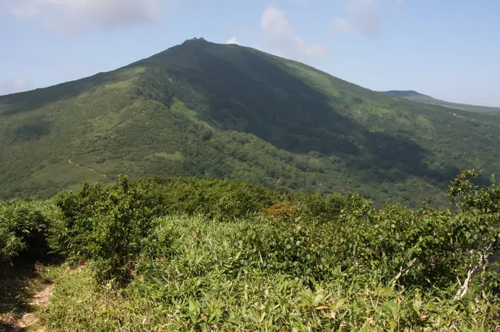
Mekunnaidake (1,220 m) is a volcano at the western end of the Niseko mountain range, straddling the boundary between Rankoshi (Iso-ya District) and Iwanai (Iwanai District) in Hokkaido. The peak lies within Niseko-Shakotan-Otaru Kaigan Quasi-National Park and is capped by a striking jumble of lava blocks; its name comes from the Ainu word 'mekunnai', meaning the valley behind. Climbed via the Niimi Pass trail over the foothill of Mae-Mekunnaidake, it is listed on the Hokkaidō Hyakumeizan and Shin Hana no Hyakumeizan.
Mekunnaidake at a glance
- Weather: The most settled day in the next 7 days is Thu, November 5: clear, gusts up to 6 m/s. Fri, Nov 6, Sat, Nov 7, Sun, Nov 8: strong wind (gusts up to 24 m/s).
- Route: The shortest is Mount Mekunnai in the Niseko Range, Return from Niimi Pass over Mae-Mekunnai: about 4 h 22 min, 7.0 km, about 640 m of climbing.
Mekunnaidake weather (hourly, 14 days)
Sunrise today 06:14, sunset 16:29
| Tue, 11/3 | Wed, 11/4 | Thu, 11/5 | Fri, 11/6 | Sat, 11/7 | Sun, 11/8 | Mon, 11/9 | Tue, 11/10 | Wed, 11/11 | Thu, 11/12 | Fri, 11/13 | Sat, 11/14 | Sun, 11/15 | Mon, 11/16 | Tue, 11/17 | |||||||||||||||||||||||||||||||||||||||||||||||||||||||||||||||||||||||
|---|---|---|---|---|---|---|---|---|---|---|---|---|---|---|---|---|---|---|---|---|---|---|---|---|---|---|---|---|---|---|---|---|---|---|---|---|---|---|---|---|---|---|---|---|---|---|---|---|---|---|---|---|---|---|---|---|---|---|---|---|---|---|---|---|---|---|---|---|---|---|---|---|---|---|---|---|---|---|---|---|---|---|---|---|---|
| Japan time | 21 | 23 | 1 | 3 | 5 | 7 | 9 | 11 | 13 | 15 | 17 | 19 | 21 | 0 | 3 | 6 | 9 | 12 | 15 | 18 | 21 | 0 | 3 | 6 | 9 | 12 | 15 | 18 | 21 | 0 | 3 | 6 | 9 | 12 | 15 | 18 | 21 | 0 | 3 | 6 | 9 | 12 | 15 | 18 | 21 | 0 | 3 | 6 | 9 | 12 | 15 | 21 | 3 | 9 | 15 | 21 | 3 | 9 | 15 | 21 | 3 | 9 | 15 | 21 | 3 | 9 | 15 | 21 | 3 | 9 | 15 | 21 | 3 | 9 | 15 | 21 | 3 | 9 | 15 | 21 | 3 | 9 | 15 | 21 | |
  |   | |   |   |   | |  | | |  | |   | | | |   | | |   |   | | | |   | |   |   | | | | |   | |   | | | | | | | | | | | | | | | |   | | | | |   | |   |   | | | | | | | | | | | | | | | | | | | | | | | | | | ||
| Temperature | °C | -5° | -7° | -7° | -4° | -4° | -3° | -3° | -2° | -1° | -2° | -6° | -8° | -9° | -9° | -8° | -7° | 0° | 3° | 4° | -1° | -1° | 0° | 0° | 1° | 4° | 7° | 2° | -2° | -5° | -7° | -8° | -9° | -8° | -7° | -7° | -6° | -7° | -7° | -7° | -8° | -7° | -6° | -7° | -7° | -8° | -8° | -9° | -9° | -8° | -8° | -8° | -11° | -10° | -7° | -7° | -13° | -11° | -6° | -4° | -8° | -8° | -6° | -4° | -7° | -8° | -9° | -7° | -7° | -8° | -5° | -3° | -8° | -5° | -2° | 0° | -3° | -3° | -4° | -6° | -8° | -8° | -5° | -4° | -6° |
| Precipitation | mm | 1.2 | 2.2 | 4.4 | 1.1 | 0.2 | 1.0 | 1.7 | 1.0 | 2.3 | 1.0 | 0.6 | 2.0 | 0.9 | 1.7 | 2.5 | 1.8 | 1.5 | 2.1 | 2.2 | 1.6 | 1.3 | 1.5 | 1.3 | 1.6 | 2.4 | 1.7 | 0.9 | 0.5 | 0.3 | 0.2 | 0.1 | 0.2 | 0.2 | 0.7 | 0.9 | 0.5 | 0.4 | 1.1 | 0.4 | 1.1 | 0.6 | 2.0 | 1.5 | 0.5 | 0.3 | 0.1 | 0.3 | 0.8 | 0.4 | 0.5 | 2.8 | 3.3 | 1.1 | |||||||||||||||||||||||||||||||
| New snow | cm | 1.1 | 2.2 | 4.1 | 0.3 | 1.0 | 2.5 | 1.8 | 1.5 | 2.1 | 2.2 | 1.6 | 1.3 | 1.5 | 1.4 | 1.6 | 2.3 | 1.7 | 0.9 | 0.5 | 0.3 | 0.2 | <.1 | 0.2 | 0.2 | 0.7 | 0.8 | 0.4 | 0.4 | 1.1 | 0.4 | 1.1 | 0.6 | 2.0 | 1.5 | <.1 | 0.5 | 0.3 | <.1 | <.1 | 0.3 | <.1 | |||||||||||||||||||||||||||||||||||||||||||
| Snow depth | cm | <1 | 4 | 6 | 6 | 6 | 5 | 5 | 4 | 4 | 3 | 3 | 3 | 3 | 3 | 3 | 3 | 3 | 2 | 1 | <1 | <1 | <1 | <1 | 0 | 0 | 0 | 0 | 0 | 0 | 2 | 3 | 5 | 6 | 7 | 8 | 9 | 10 | 12 | 13 | 14 | 15 | 15 | 16 | 16 | 16 | 16 | 16 | 16 | 15 | 15 | 15 | 15 | 16 | 16 | 15 | 15 | 16 | 16 | 15 | 14 | 14 | 16 | 16 | 16 | 16 | 15 | 15 | 15 | 15 | 15 | 14 | 14 | 14 | 12 | 9 | 8 | 7 | 5 | 5 | 5 | 5 | 5 | 4 | 4 |
| Wind | m/s | 2 | 1 | 1 | 2 | 4 | 4 | 4 | 2 | 1 | 1 | 0 | 1 | 1 | 1 | 1 | 1 | 1 | 1 | 1 | 1 | 1 | 2 | 0 | 0 | 1 | 2 | 6 | 5 | 4 | 5 | 5 | 5 | 5 | 7 | 8 | 7 | 7 | 6 | 6 | 5 | 5 | 5 | 5 | 3 | 2 | 2 | 1 | 1 | 2 | 3 | 3 | 1 | 1 | 0 | 1 | 1 | 1 | 1 | 2 | 0 | 1 | 1 | 2 | 3 | 2 | 5 | 4 | 2 | 1 | 0 | 1 | 1 | 1 | 1 | 1 | 1 | 1 | 1 | 4 | 3 | 2 | 3 | 2 | 1 |
| Wind gusts | m/s | 8 | 7 | 8 | 11 | 12 | 12 | 13 | 11 | 7 | 4 | 4 | 4 | 5 | 5 | 6 | 5 | 6 | 5 | 5 | 5 | 6 | 7 | 7 | 3 | 5 | 10 | 16 | 18 | 15 | 18 | 19 | 19 | 19 | 21 | 24 | 25 | 24 | 22 | 19 | 18 | 16 | 15 | 16 | 14 | 10 | 8 | 7 | 6 | 8 | 10 | 10 | 10 | 5 | 4 | 5 | 4 | 4 | 4 | 8 | 7 | 5 | 5 | 12 | 9 | 9 | 14 | 14 | 11 | 7 | 4 | 5 | 4 | 6 | 6 | 5 | 6 | 5 | 5 | 13 | 14 | 10 | 8 | 8 | 7 |
| Wind dir. | ↓ | ↓ | ↓ | ↓ | ↓ | ↓ | ↓ | ↓ | ↓ | ↓ | ↓ | ↓ | ↓ | ↓ | ↓ | ↓ | ↓ | ↓ | ↓ | ↓ | ↓ | ↓ | ↓ | ↓ | ↓ | ↓ | ↓ | ↓ | ↓ | ↓ | ↓ | ↓ | ↓ | ↓ | ↓ | ↓ | ↓ | ↓ | ↓ | ↓ | ↓ | ↓ | ↓ | ↓ | ↓ | ↓ | ↓ | ↓ | ↓ | ↓ | ↓ | ↓ | ↓ | ↓ | ↓ | ↓ | ↓ | ↓ | ↓ | ↓ | ↓ | ↓ | ↓ | ↓ | ↓ | ↓ | ↓ | ↓ | ↓ | ↓ | ↓ | ↓ | ↓ | ↓ | ↓ | ↓ | ↓ | ↓ | ↓ | ↓ | ↓ | ↓ | ↓ | ↓ | |
Mekunnaidake hiking routes
Hiking times are estimates calculated from the terrain.
Lists that include Mekunnaidake
New 100 Famous Flower Mountains · Hokkaido 100 Famous Mountains · Elevations of 1003 Mountains of Japan · 1000 Mountains of Japan
Mekunnaidake facts
- Elevation
- 1,220 m
- Location
- Rankoshi, Hokkaido / Iwanai, Hokkaido
42.899735, 140.515287 - National Park
- ニセコ積丹小樽海岸国定公園
- Website
- www.pref.hokkaido.lg.jp
- Trail Map
- www.iwanai-kanko.jp (PDF)
- Wikipedia
- ja.wikipedia.org