
Mount Nitonupuri
ニトヌプリ
Rankoshi, Hokkaido · Elevation 1,080 m
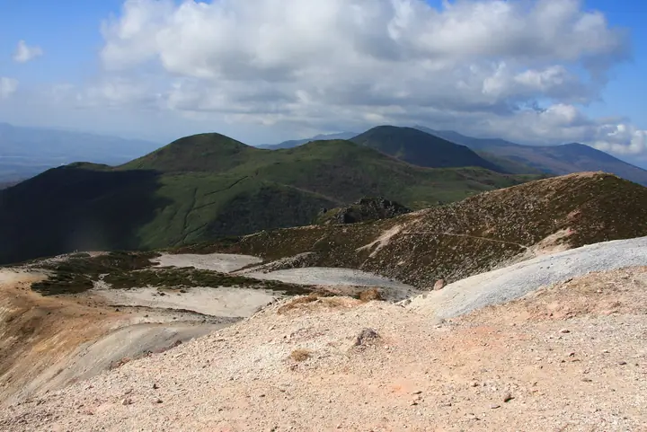
Mount Nitonupuri is a 1,080 m mountain in the central Niseko range, set between Iwaonupuri and Chisenupuri and in Rankoshi. Climbed from trailheads along the Niseko Panorama Line (Route 66) or from Goshiki Onsen, it gives views of the range's peaks and Mount Yōtei. It lies within Niseko-Shakotan-Otaru Quasi-National Park. It has northern and southern summits, with the trail passing over the north summit.
Mount Nitonupuri at a glance
- Weather: The most settled day in the next 7 days is Thu, November 5: clear, gusts up to 6 m/s. Fri, Nov 6, Sat, Nov 7, Sun, Nov 8: strong wind (gusts up to 19 m/s).
Mount Nitonupuri weather (hourly, 14 days)
Sunrise today 06:13, sunset 16:29
| Tue, 11/3 | Wed, 11/4 | Thu, 11/5 | Fri, 11/6 | Sat, 11/7 | Sun, 11/8 | Mon, 11/9 | Tue, 11/10 | Wed, 11/11 | Thu, 11/12 | Fri, 11/13 | Sat, 11/14 | Sun, 11/15 | Mon, 11/16 | Tue, 11/17 | |||||||||||||||||||||||||||||||||||||||||||||||||||||||||||||||||||||||
|---|---|---|---|---|---|---|---|---|---|---|---|---|---|---|---|---|---|---|---|---|---|---|---|---|---|---|---|---|---|---|---|---|---|---|---|---|---|---|---|---|---|---|---|---|---|---|---|---|---|---|---|---|---|---|---|---|---|---|---|---|---|---|---|---|---|---|---|---|---|---|---|---|---|---|---|---|---|---|---|---|---|---|---|---|---|
| Japan time | 15 | 17 | 19 | 21 | 23 | 1 | 3 | 5 | 7 | 9 | 11 | 13 | 15 | 18 | 21 | 0 | 3 | 6 | 9 | 12 | 15 | 18 | 21 | 0 | 3 | 6 | 9 | 12 | 15 | 18 | 21 | 0 | 3 | 6 | 9 | 12 | 15 | 18 | 21 | 0 | 3 | 6 | 9 | 12 | 15 | 18 | 21 | 0 | 3 | 6 | 9 | 15 | 21 | 3 | 9 | 15 | 21 | 3 | 9 | 15 | 21 | 3 | 9 | 15 | 21 | 3 | 9 | 15 | 21 | 3 | 9 | 15 | 21 | 3 | 9 | 15 | 21 | 3 | 9 | 15 | 21 | 3 | 9 | 15 | |
  |   |   | | | |   |   | | |   |  | |  |   | | | | | | |   |   |   | | |   | |   | | | | | |   | | | | | | | | | | | | | | | | | | | |   | | | | |   | | | | | | | | | | | | | | | | | | |   | | | | | | ||
| Temperature | °C | -1° | -3° | -4° | -6° | -6° | -5° | -4° | -3° | -2° | -1° | 0° | 0° | 0° | -6° | -8° | -8° | -8° | -6° | 1° | 6° | 6° | 1° | 0° | 0° | 1° | 1° | 6° | 8° | 3° | -1° | -4° | -6° | -7° | -7° | -6° | -5° | -6° | -5° | -6° | -6° | -7° | -7° | -6° | -5° | -5° | -5° | -6° | -7° | -7° | -8° | -5° | -6° | -11° | -8° | -6° | -5° | -11° | -9° | -5° | -2° | -7° | -8° | -4° | -3° | -6° | -8° | -7° | -6° | -6° | -9° | -4° | -2° | -8° | -5° | -1° | 1° | -2° | -2° | -3° | -4° | -8° | -8° | -3° | -2° |
| Precipitation | mm | 0.2 | 0.2 | 0.6 | 2.7 | 3.7 | 2.3 | 0.1 | 1.4 | 3.1 | 1.1 | 0.3 | 0.5 | 2.1 | 0.3 | 0.9 | 2.0 | 1.5 | 1.6 | 1.6 | 2.2 | 1.9 | 1.8 | 1.4 | 1.9 | 1.4 | 1.8 | 1.6 | 1.4 | 1.2 | 0.7 | 0.2 | 0.2 | 0.3 | 0.1 | 0.1 | 0.3 | 0.2 | 0.8 | 0.2 | 0.9 | 0.8 | 1.2 | 1.2 | 0.2 | 0.2 | 0.1 | 0.2 | 0.7 | 0.3 | 0.7 | 3.5 | 4.5 | 1.1 | |||||||||||||||||||||||||||||||
| New snow | cm | 0.1 | 0.2 | 0.6 | 2.7 | 3.6 | 1.2 | 0.4 | 2.0 | 1.5 | 1.6 | 1.6 | 2.2 | 1.9 | 1.8 | 1.4 | 1.9 | 1.4 | 1.8 | 1.6 | 1.4 | 1.2 | 0.7 | 0.3 | 0.2 | 0.3 | 0.1 | 0.1 | 0.3 | 0.2 | 0.8 | 0.2 | 0.9 | 0.8 | 1.2 | 1.2 | <.1 | 0.2 | 0.2 | <.1 | <.1 | 0.5 | <.1 | <.1 | |||||||||||||||||||||||||||||||||||||||||
| Snow depth | cm | <1 | <1 | <1 | <1 | 3 | 6 | 7 | 7 | 7 | 6 | 5 | 5 | 4 | 4 | 4 | 4 | 4 | 4 | 3 | 3 | 2 | <1 | <1 | <1 | <1 | 0 | 0 | 0 | 0 | 0 | 0 | 1 | 2 | 4 | 4 | 6 | 7 | 8 | 8 | 9 | 10 | 11 | 12 | 13 | 13 | 14 | 14 | 14 | 14 | 14 | 13 | 13 | 13 | 14 | 14 | 13 | 13 | 14 | 14 | 13 | 12 | 12 | 14 | 14 | 14 | 14 | 13 | 13 | 13 | 13 | 13 | 12 | 12 | 12 | 11 | 9 | 8 | 7 | 6 | 6 | 5 | 5 | 5 | 5 |
| Wind | m/s | 4 | 1 | 1 | 1 | 1 | 1 | 1 | 3 | 4 | 3 | 2 | 1 | 0 | 1 | 1 | 1 | 1 | 1 | 0 | 1 | 1 | 1 | 1 | 1 | 1 | 1 | 2 | 4 | 5 | 4 | 4 | 4 | 3 | 4 | 5 | 5 | 4 | 6 | 5 | 5 | 5 | 5 | 4 | 4 | 4 | 3 | 2 | 1 | 1 | 1 | 3 | 3 | 1 | 1 | 0 | 1 | 1 | 1 | 1 | 2 | 0 | 1 | 1 | 2 | 2 | 1 | 5 | 3 | 1 | 1 | 0 | 1 | 1 | 1 | 1 | 1 | 1 | 1 | 1 | 3 | 2 | 1 | 2 | 1 |
| Wind gusts | m/s | 13 | 11 | 6 | 6 | 7 | 8 | 10 | 11 | 13 | 13 | 12 | 8 | 5 | 4 | 5 | 5 | 6 | 5 | 5 | 5 | 6 | 4 | 4 | 6 | 6 | 6 | 8 | 12 | 17 | 17 | 14 | 16 | 14 | 15 | 19 | 18 | 19 | 21 | 21 | 18 | 18 | 17 | 16 | 15 | 15 | 13 | 12 | 9 | 6 | 6 | 10 | 11 | 9 | 5 | 4 | 6 | 5 | 4 | 4 | 8 | 6 | 5 | 5 | 11 | 8 | 8 | 14 | 14 | 10 | 6 | 4 | 5 | 4 | 6 | 7 | 6 | 6 | 5 | 5 | 11 | 13 | 9 | 7 | 7 |
| Wind dir. | ↓ | ↓ | ↓ | ↓ | ↓ | ↓ | ↓ | ↓ | ↓ | ↓ | ↓ | ↓ | ↓ | ↓ | ↓ | ↓ | ↓ | ↓ | ↓ | ↓ | ↓ | ↓ | ↓ | ↓ | ↓ | ↓ | ↓ | ↓ | ↓ | ↓ | ↓ | ↓ | ↓ | ↓ | ↓ | ↓ | ↓ | ↓ | ↓ | ↓ | ↓ | ↓ | ↓ | ↓ | ↓ | ↓ | ↓ | ↓ | ↓ | ↓ | ↓ | ↓ | ↓ | ↓ | ↓ | ↓ | ↓ | ↓ | ↓ | ↓ | ↓ | ↓ | ↓ | ↓ | ↓ | ↓ | ↓ | ↓ | ↓ | ↓ | ↓ | ↓ | ↓ | ↓ | ↓ | ↓ | ↓ | ↓ | ↓ | ↓ | ↓ | ↓ | ↓ | ↓ | |
Huts, campsites and lodging near Mount Nitonupuri
Campsites
- ニセコ野営場
- 湯本温泉野営場
Lodging
- niseko goshiki onsen bekkan
- 月美の宿紅葉音
- Moiwa Lodge
- One Niseko Resort Towers
- Niseko Backcountry Lodge
Mount Nitonupuri facts
- Elevation
- 1,080 m
- Location
- Rankoshi, Hokkaido
42.885194, 140.617999 - National Park
- ニセコ積丹小樽海岸国定公園
- Volcano
- Active volcano (ニセコ)
- Website
- niseko-goshiki-info.com
- Wikipedia
- ja.wikipedia.org