
Mt. Tsushidake
津志嶽
Tsurugi, Tokushima · Elevation 1,494 m
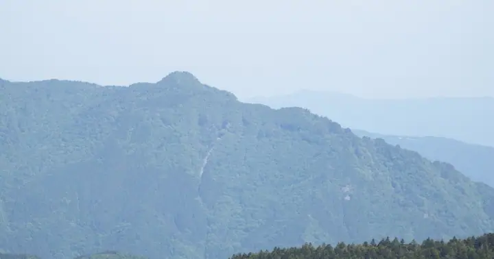
A 1,493.7 m peak in Tsurugi Town, Mima District, Tokushima Prefecture, in the eastern Iya Range and one of the Shikoku Hyakumeizan. Seen from the southern Mt. Tsurugi side it presents a camel-hump silhouette amid the otherwise screen-like Iya Range, with cliffs ringing the summit like a fortress. The customary route is the pilgrim path climbing from the Kusabu hamlet through the torii of Tsushidake Shrine, past the Ishizuchi-san Daigongen hall and the upper Tsushidake Shrine, on to the summit.
Mt. Tsushidake at a glance
- Weather: The most settled day in the next 7 days is Sun, November 8: clear, gusts up to 7 m/s.
Mt. Tsushidake weather (hourly, 14 days)
Sunrise today 06:24, sunset 17:11
| Tue, 11/3 | Wed, 11/4 | Thu, 11/5 | Fri, 11/6 | Sat, 11/7 | Sun, 11/8 | Mon, 11/9 | Tue, 11/10 | Wed, 11/11 | Thu, 11/12 | Fri, 11/13 | Sat, 11/14 | Sun, 11/15 | Mon, 11/16 | Tue, 11/17 | |||||||||||||||||||||||||||||||||||||||||||||||||||||||||||||||||||||||
|---|---|---|---|---|---|---|---|---|---|---|---|---|---|---|---|---|---|---|---|---|---|---|---|---|---|---|---|---|---|---|---|---|---|---|---|---|---|---|---|---|---|---|---|---|---|---|---|---|---|---|---|---|---|---|---|---|---|---|---|---|---|---|---|---|---|---|---|---|---|---|---|---|---|---|---|---|---|---|---|---|---|---|---|---|---|
| Japan time | 15 | 17 | 19 | 21 | 23 | 1 | 3 | 5 | 7 | 9 | 11 | 13 | 15 | 18 | 21 | 0 | 3 | 6 | 9 | 12 | 15 | 18 | 21 | 0 | 3 | 6 | 9 | 12 | 15 | 18 | 21 | 0 | 3 | 6 | 9 | 12 | 15 | 18 | 21 | 0 | 3 | 6 | 9 | 12 | 15 | 18 | 21 | 0 | 3 | 6 | 9 | 15 | 21 | 3 | 9 | 15 | 21 | 3 | 9 | 15 | 21 | 3 | 9 | 15 | 21 | 3 | 9 | 15 | 21 | 3 | 9 | 15 | 21 | 3 | 9 | 15 | 21 | 3 | 9 | 15 | 21 | 3 | 9 | 15 | |
 |   |   |   | | | | |   | |   | | | |   | | | |   | |   | | |   | | |   | | |  | | | | | | | | | | | | | | | | | | | | | | | | | | |   | | | | | | | | | | | | | | | | |   | | | | | | | | | | | ||
| Temperature | °C | 8° | 5° | 4° | 4° | 3° | 4° | 4° | 3° | 3° | 4° | 8° | 7° | 8° | 6° | 6° | 6° | 7° | 6° | 9° | 13° | 13° | 8° | 9° | 9° | 8° | 6° | 6° | 9° | 8° | 4° | 2° | 0° | 0° | -1° | 1° | 3° | 4° | -1° | -1° | -3° | -4° | -4° | 3° | 6° | 5° | 0° | 1° | 0° | 0° | 2° | 5° | 7° | 1° | -1° | 3° | 5° | 0° | -2° | 0° | 2° | -2° | -6° | 2° | 5° | -1° | -1° | 3° | 4° | -2° | -4° | 4° | 8° | -1° | -1° | 8° | 9° | 7° | 7° | 7° | 8° | 3° | -1° | 1° | 5° |
| Precipitation | mm | 0.2 | 1.1 | 0.7 | 1.3 | 0.4 | 0.2 | 1.1 | 0.7 | 0.1 | 0.6 | 0.4 | 0.2 | 0.2 | 0.1 | 0.6 | 0.1 | 2.0 | 1.1 | 2.3 | 3.7 | 0.8 | |||||||||||||||||||||||||||||||||||||||||||||||||||||||||||||||
| New snow | cm | ||||||||||||||||||||||||||||||||||||||||||||||||||||||||||||||||||||||||||||||||||||
| Snow depth | cm | 0 | 0 | 0 | 0 | 0 | 0 | 0 | 0 | 0 | 0 | 0 | 0 | 0 | 0 | 0 | 0 | 0 | 0 | 0 | 0 | 0 | 0 | 0 | 0 | 0 | 0 | 0 | 0 | 0 | 0 | 0 | 0 | 0 | 0 | 0 | 0 | 0 | 0 | 0 | 0 | 0 | 0 | 0 | 0 | 0 | 0 | 0 | 0 | 0 | 0 | 0 | 0 | 0 | 0 | 0 | 0 | 0 | 0 | 0 | 0 | 0 | 0 | 0 | 0 | 0 | 0 | 0 | 0 | 0 | 0 | 0 | 0 | 0 | 0 | 0 | 0 | 0 | 0 | 0 | 0 | 0 | 0 | 0 | 0 |
| Wind | m/s | 2 | 0 | 0 | 0 | 1 | 1 | 1 | 2 | 2 | 2 | 2 | 2 | 1 | 1 | 0 | 2 | 1 | 1 | 0 | 0 | 1 | 1 | 2 | 2 | 4 | 3 | 4 | 5 | 5 | 4 | 4 | 4 | 3 | 4 | 5 | 4 | 4 | 1 | 1 | 1 | 1 | 1 | 1 | 2 | 2 | 1 | 1 | 1 | 1 | 1 | 2 | 3 | 1 | 2 | 2 | 3 | 3 | 4 | 3 | 4 | 0 | 1 | 1 | 3 | 2 | 2 | 2 | 3 | 0 | 1 | 1 | 2 | 2 | 2 | 2 | 2 | 2 | 2 | 3 | 4 | 2 | 1 | 1 | 2 |
| Wind gusts | m/s | 7 | 7 | 3 | 3 | 3 | 3 | 4 | 5 | 6 | 7 | 7 | 6 | 5 | 5 | 4 | 7 | 7 | 3 | 4 | 4 | 6 | 5 | 7 | 8 | 12 | 12 | 12 | 14 | 14 | 14 | 13 | 13 | 12 | 13 | 14 | 14 | 13 | 11 | 6 | 5 | 4 | 4 | 4 | 6 | 7 | 6 | 3 | 4 | 4 | 4 | 7 | 10 | 8 | 5 | 8 | 11 | 11 | 13 | 13 | 13 | 11 | 4 | 5 | 8 | 8 | 7 | 8 | 10 | 9 | 3 | 5 | 6 | 6 | 6 | 8 | 11 | 12 | 9 | 10 | 13 | 12 | 7 | 4 | 8 |
| Wind dir. | ↓ | ↓ | ↓ | ↓ | ↓ | ↓ | ↓ | ↓ | ↓ | ↓ | ↓ | ↓ | ↓ | ↓ | ↓ | ↓ | ↓ | ↓ | ↓ | ↓ | ↓ | ↓ | ↓ | ↓ | ↓ | ↓ | ↓ | ↓ | ↓ | ↓ | ↓ | ↓ | ↓ | ↓ | ↓ | ↓ | ↓ | ↓ | ↓ | ↓ | ↓ | ↓ | ↓ | ↓ | ↓ | ↓ | ↓ | ↓ | ↓ | ↓ | ↓ | ↓ | ↓ | ↓ | ↓ | ↓ | ↓ | ↓ | ↓ | ↓ | ↓ | ↓ | ↓ | ↓ | ↓ | ↓ | ↓ | ↓ | ↓ | ↓ | ↓ | ↓ | ↓ | ↓ | ↓ | ↓ | ↓ | ↓ | ↓ | ↓ | ↓ | ↓ | ↓ | ↓ | |
Huts, campsites and lodging near Mt. Tsushidake
Lodging
- つるぎの宿 岩戸
Lists that include Mt. Tsushidake
Mt. Tsushidake facts
- Elevation
- 1,494 m
- Location
- Tsurugi, Tokushima
33.931597, 134.028928 - Website
- www.town.tokushima-tsurugi.lg.jp
- Trail Map
- www.town.tokushima-tsurugi.lg.jp (PDF)
- Access Information
- www.town.tokushima-tsurugi.lg.jp
- Wikipedia
- ja.wikipedia.org