
Mt. Shirakimine
白木峰
Hida, Gifu · Elevation 1,596 m
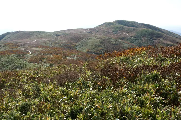
Mt. Shirakimine (1,596 m) sits on the border between Toyama City (Toyama) and Hida City (Gifu) in the northern Hida Highlands. The summit area is an open grass-and-wetland ridge designated as Shiraki-Mizunashi Prefectural Natural Park, famous for sub-alpine wildflowers such as nikko-kisuge that bloom in midsummer. The peak is included in Japan's 300 Famous Mountains, the 100 Mountains of Toyama, and the 100 Mountains of Gifu. From the Toyama side, hikers drive Forest Road Otani-sen to the eighth-station car park and reach the summit plateau and boardwalk in a relatively short walk.
Mt. Shirakimine at a glance
- Weather: The most settled day in the next 7 days is Wed, November 4: clear, gusts up to 6 m/s.
- Route: The shortest is Mount Shirakimine and Ukishima Pond Circuit from the Eighth-Station Trailhead: about 2 h 43 min, 5.5 km, about 340 m of climbing.
Mt. Shirakimine weather (hourly, 14 days)
Sunrise today 06:16, sunset 16:54
| Tue, 11/3 | Wed, 11/4 | Thu, 11/5 | Fri, 11/6 | Sat, 11/7 | Sun, 11/8 | Mon, 11/9 | Tue, 11/10 | Wed, 11/11 | Thu, 11/12 | Fri, 11/13 | Sat, 11/14 | Sun, 11/15 | Mon, 11/16 | Tue, 11/17 | |||||||||||||||||||||||||||||||||||||||||||||||||||||||||||||||||||||||
|---|---|---|---|---|---|---|---|---|---|---|---|---|---|---|---|---|---|---|---|---|---|---|---|---|---|---|---|---|---|---|---|---|---|---|---|---|---|---|---|---|---|---|---|---|---|---|---|---|---|---|---|---|---|---|---|---|---|---|---|---|---|---|---|---|---|---|---|---|---|---|---|---|---|---|---|---|---|---|---|---|---|---|---|---|---|
| Japan time | 15 | 17 | 19 | 21 | 23 | 1 | 3 | 5 | 7 | 9 | 11 | 13 | 15 | 18 | 21 | 0 | 3 | 6 | 9 | 12 | 15 | 18 | 21 | 0 | 3 | 6 | 9 | 12 | 15 | 18 | 21 | 0 | 3 | 6 | 9 | 12 | 15 | 18 | 21 | 0 | 3 | 6 | 9 | 12 | 15 | 18 | 21 | 0 | 3 | 6 | 9 | 15 | 21 | 3 | 9 | 15 | 21 | 3 | 9 | 15 | 21 | 3 | 9 | 15 | 21 | 3 | 9 | 15 | 21 | 3 | 9 | 15 | 21 | 3 | 9 | 15 | 21 | 3 | 9 | 15 | 21 | 3 | 9 | 15 | |
  |   |  | | | | | | |  | | |   |   | |   | | |   |   | | |   |   | | | | | | | | | | | | | | | |   | | | | | | | | | | | | | | | | | |   |   | | | | |   | | | | |  | | | | | | | | | | | | | | | | ||
| Temperature | °C | 6° | 2° | 0° | 1° | 1° | 1° | 0° | 0° | 0° | 5° | 8° | 9° | 7° | 4° | 5° | 5° | 5° | 5° | 6° | 10° | 12° | 8° | 7° | 7° | 6° | 7° | 8° | 10° | 7° | 4° | 2° | 1° | 0° | -1° | -1° | 0° | -1° | -2° | -1° | -2° | -2° | -2° | 1° | 3° | 2° | 0° | 0° | 0° | 0° | 0° | 5° | 3° | 0° | -1° | 4° | 8° | 1° | -3° | -1° | 1° | -1° | -2° | 1° | 2° | -2° | 0° | 0° | 1° | -2° | -2° | 2° | 6° | 1° | 2° | 6° | 6° | 6° | 7° | 5° | 3° | -1° | -3° | 0° | 1° |
| Precipitation | mm | 3.1 | 6 | 6 | 4.2 | 0.5 | 0.7 | 1.9 | 2.5 | 2.9 | 1.0 | 1.8 | 0.5 | 0.5 | 1.2 | 2.3 | 1.1 | 1.5 | 2.5 | 1.7 | 1.3 | 0.7 | 0.3 | 0.2 | 0.2 | 0.8 | 0.5 | 1.4 | 0.6 | 3.3 | 6 | 1.0 | 2.0 | 0.5 | 1.0 | 6 | 1.2 | 3.6 | 5.0 | 3.0 | 11 | 10 | 4.9 | 0.7 | |||||||||||||||||||||||||||||||||||||||||
| New snow | cm | 1.8 | 0.5 | <.1 | |||||||||||||||||||||||||||||||||||||||||||||||||||||||||||||||||||||||||||||||||
| Snow depth | cm | 0 | 0 | 0 | 0 | 0 | 0 | 0 | 0 | 0 | 0 | 0 | 0 | 0 | 0 | 0 | 0 | 0 | 0 | 0 | 0 | 0 | 0 | 0 | 0 | 0 | 0 | 0 | 0 | 0 | 0 | 0 | 0 | 0 | 0 | 0 | 0 | 0 | 0 | 0 | 0 | 0 | 0 | 0 | 0 | 0 | 0 | 0 | 0 | 0 | 0 | 0 | 0 | 0 | 0 | 0 | 0 | 0 | <1 | <1 | 0 | 0 | 0 | 0 | 0 | 0 | 0 | 0 | 0 | 0 | 0 | 0 | 0 | 0 | 0 | 0 | 0 | 0 | 0 | 0 | 0 | 0 | 0 | 0 | 0 |
| Wind | m/s | 2 | 1 | 0 | 0 | 0 | 0 | 0 | 0 | 0 | 1 | 2 | 2 | 2 | 0 | 1 | 1 | 2 | 1 | 2 | 1 | 1 | 0 | 1 | 3 | 1 | 1 | 2 | 4 | 4 | 2 | 2 | 2 | 2 | 3 | 2 | 3 | 2 | 1 | 2 | 1 | 1 | 1 | 2 | 4 | 3 | 0 | 0 | 0 | 0 | 1 | 0 | 3 | 1 | 0 | 2 | 4 | 2 | 3 | 3 | 3 | 1 | 1 | 0 | 2 | 2 | 1 | 3 | 3 | 2 | 0 | 2 | 2 | 4 | 4 | 5 | 4 | 5 | 4 | 3 | 4 | 3 | 2 | 2 | 2 |
| Wind gusts | m/s | 8 | 6 | 3 | 2 | 2 | 2 | 2 | 2 | 2 | 4 | 5 | 6 | 6 | 5 | 6 | 6 | 5 | 8 | 6 | 6 | 6 | 4 | 4 | 8 | 8 | 5 | 9 | 11 | 13 | 12 | 9 | 10 | 11 | 10 | 10 | 12 | 9 | 6 | 6 | 6 | 4 | 5 | 7 | 10 | 11 | 8 | 3 | 3 | 3 | 5 | 5 | 7 | 7 | 4 | 8 | 14 | 12 | 13 | 14 | 13 | 10 | 4 | 4 | 9 | 6 | 8 | 9 | 11 | 10 | 6 | 7 | 7 | 10 | 12 | 15 | 16 | 16 | 20 | 12 | 11 | 11 | 10 | 6 | 7 |
| Wind dir. | ↓ | ↓ | ↓ | ↓ | ↓ | ↓ | ↓ | ↓ | ↓ | ↓ | ↓ | ↓ | ↓ | ↓ | ↓ | ↓ | ↓ | ↓ | ↓ | ↓ | ↓ | ↓ | ↓ | ↓ | ↓ | ↓ | ↓ | ↓ | ↓ | ↓ | ↓ | ↓ | ↓ | ↓ | ↓ | ↓ | ↓ | ↓ | ↓ | ↓ | ↓ | ↓ | ↓ | ↓ | ↓ | ↓ | ↓ | ↓ | ↓ | ↓ | ↓ | ↓ | ↓ | ↓ | ↓ | ↓ | ↓ | ↓ | ↓ | ↓ | ↓ | ↓ | ↓ | ↓ | ↓ | ↓ | ↓ | ↓ | ↓ | ↓ | ↓ | ↓ | ↓ | ↓ | ↓ | ↓ | ↓ | ↓ | ↓ | ↓ | ↓ | ↓ | ↓ | ↓ | |
Mt. Shirakimine hiking routes
Hiking times are estimates calculated from the terrain.
Huts, campsites and lodging near Mt. Shirakimine
Mountain huts
Lists that include Mt. Shirakimine
Japan's 300 Famous Mountains · 100 Mountains of Hokuriku · 100 Mountains of Toyama · 100 Mountains of Gifu · Elevations of 1003 Mountains of Japan · 1000 Mountains of Japan
Mt. Shirakimine facts
- Also known as
- しろきみね
- Elevation
- 1,596 m
- Location
- Hida, Gifu
36.415550, 137.112202 - Website
- www.city.toyama.lg.jp
- Trail Map
- www.city.toyama.lg.jp (PDF)
- Wikipedia
- ja.wikipedia.org