
Mt. Koumoridake
蝙蝠岳
Shizuoka, Shizuoka · Elevation 2,865 m
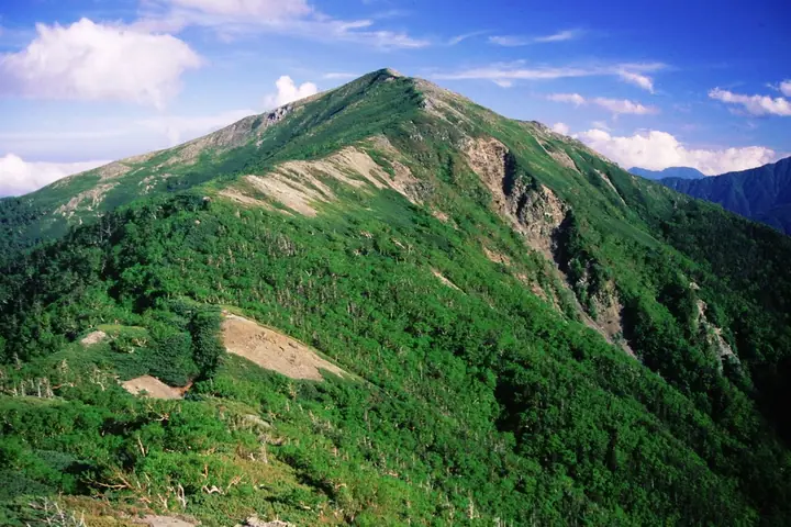
Mt. Koumoridake ("Bat Peak") is a 2,864.69-meter mountain in central Aoi Ward, Shizuoka City, on the main mass of the Akaishi Range (Southern Alps) within South Alps National Park. It rises on the Komori-one ridge that branches southeast from Mt. Kitamatadake just below Mt. Shiomi, continuing southeast through Mt. Tokuemondake toward the Nikenkoya Lodge near the headwaters of the Ōigawa River. The summit lies above the treeline in creeping-pine and rock terrain, with sweeping views of Mt. Fuji, the Arakawa peaks, Mt. Shiomi, and the Shirane Southern Ridge. The two access lines — a >3-hour out-and-back from Mt. Shiomidake via Mt. Kitamatadake, and a ~6-hour climb up the Komori-one from Nikenkoya — see few hikers due to the remoteness. The peak appears in the Nihon Hyaku-Kōzan (100 Highest Mountains of Japan), Nihon 2500-m Peaks, Shizuoka Hyakuzan, and Fuji-no-mieru-Yama 223 lists.
Mt. Koumoridake at a glance
- Weather: The most settled day in the next 7 days is Sun, November 8: clear, gusts up to 8 m/s.
Mt. Koumoridake weather (hourly, 14 days)
Sunrise today 06:10, sunset 16:51
| Tue, 11/3 | Wed, 11/4 | Thu, 11/5 | Fri, 11/6 | Sat, 11/7 | Sun, 11/8 | Mon, 11/9 | Tue, 11/10 | Wed, 11/11 | Thu, 11/12 | Fri, 11/13 | Sat, 11/14 | Sun, 11/15 | Mon, 11/16 | Tue, 11/17 | |||||||||||||||||||||||||||||||||||||||||||||||||||||||||||||||||||||||
|---|---|---|---|---|---|---|---|---|---|---|---|---|---|---|---|---|---|---|---|---|---|---|---|---|---|---|---|---|---|---|---|---|---|---|---|---|---|---|---|---|---|---|---|---|---|---|---|---|---|---|---|---|---|---|---|---|---|---|---|---|---|---|---|---|---|---|---|---|---|---|---|---|---|---|---|---|---|---|---|---|---|---|---|---|---|
| Japan time | 15 | 17 | 19 | 21 | 23 | 1 | 3 | 5 | 7 | 9 | 11 | 13 | 15 | 18 | 21 | 0 | 3 | 6 | 9 | 12 | 15 | 18 | 21 | 0 | 3 | 6 | 9 | 12 | 15 | 18 | 21 | 0 | 3 | 6 | 9 | 12 | 15 | 18 | 21 | 0 | 3 | 6 | 9 | 12 | 15 | 18 | 21 | 0 | 3 | 6 | 9 | 15 | 21 | 3 | 9 | 15 | 21 | 3 | 9 | 15 | 21 | 3 | 9 | 15 | 21 | 3 | 9 | 15 | 21 | 3 | 9 | 15 | 21 | 3 | 9 | 15 | 21 | 3 | 9 | 15 | 21 | 3 | 9 | 15 | |
 |   |   |   |   | | | |   |   | |   |   |   | | | | | | |   |  | | | | | | | | | | | | | | | | | | | | | | | | | |   | | | | | | | |   | |   | | |   |  | | | | | | | | | | | | | | | | |   | | | | | | ||
| Temperature | °C | 1° | -4° | -6° | -8° | -8° | -7° | -6° | -5° | -4° | 0° | 3° | 2° | 0° | -2° | -1° | -1° | -1° | 0° | 3° | 7° | 3° | 1° | -1° | -2° | -1° | -1° | 2° | 6° | 4° | -3° | -5° | -8° | -10° | -12° | -4° | -1° | -2° | -9° | -10° | -10° | -9° | -8° | 0° | 1° | 0° | -6° | -6° | -5° | -6° | -6° | -2° | -1° | -8° | -10° | -3° | -2° | -6° | -9° | -6° | -3° | -9° | -8° | -3° | -2° | -8° | -9° | -3° | -1° | -8° | -7° | -1° | 0° | -8° | -7° | 0° | 0° | -1° | -1° | 3° | 4° | -5° | -4° | -3° | -2° |
| Precipitation | mm | 0.1 | 0.4 | 1.1 | 0.3 | 7 | 12 | 6 | 0.1 | 1.2 | 1.1 | 0.1 | 0.2 | 0.3 | 12 | 18 | 0.5 | 0.1 | 0.4 | ||||||||||||||||||||||||||||||||||||||||||||||||||||||||||||||||||
| New snow | cm | <.1 | <.1 | 0.2 | |||||||||||||||||||||||||||||||||||||||||||||||||||||||||||||||||||||||||||||||||
| Snow depth | cm | 0 | 0 | 0 | 0 | 0 | 0 | 0 | 0 | 0 | 0 | 0 | 0 | 0 | 0 | 0 | 0 | 0 | 0 | 0 | 0 | 0 | 0 | 0 | 0 | 0 | 0 | 0 | 0 | 0 | 0 | 0 | 0 | 0 | 0 | 0 | 0 | 0 | 0 | 0 | 0 | 0 | 0 | 0 | 0 | 0 | 0 | 0 | 0 | 0 | 0 | 0 | 0 | 0 | 0 | 0 | 0 | 0 | 0 | 0 | 0 | 0 | 0 | 0 | 0 | 0 | 0 | 0 | 0 | 0 | 0 | 0 | 0 | 0 | 0 | 0 | 0 | 0 | 0 | 0 | 0 | 0 | 0 | 0 | 0 |
| Wind | m/s | 1 | 0 | 0 | 1 | 1 | 0 | 0 | 0 | 0 | 1 | 2 | 1 | 1 | 1 | 1 | 1 | 1 | 1 | 1 | 1 | 2 | 1 | 1 | 1 | 2 | 1 | 2 | 2 | 1 | 1 | 1 | 1 | 1 | 2 | 2 | 2 | 1 | 0 | 0 | 0 | 0 | 0 | 0 | 1 | 0 | 0 | 1 | 1 | 1 | 1 | 1 | 0 | 1 | 1 | 1 | 2 | 2 | 3 | 2 | 0 | 0 | 1 | 1 | 0 | 0 | 1 | 1 | 0 | 0 | 0 | 0 | 0 | 1 | 1 | 1 | 1 | 1 | 1 | 2 | 1 | 0 | 1 | 0 | 0 |
| Wind gusts | m/s | 8 | 7 | 5 | 6 | 6 | 6 | 6 | 6 | 5 | 6 | 8 | 8 | 7 | 6 | 7 | 8 | 9 | 10 | 7 | 8 | 11 | 10 | 8 | 9 | 11 | 11 | 10 | 11 | 11 | 9 | 10 | 11 | 13 | 13 | 13 | 13 | 11 | 9 | 8 | 8 | 8 | 8 | 7 | 8 | 8 | 6 | 7 | 8 | 8 | 9 | 9 | 10 | 6 | 7 | 8 | 11 | 10 | 16 | 17 | 14 | 7 | 6 | 8 | 8 | 7 | 6 | 9 | 9 | 7 | 5 | 5 | 6 | 6 | 7 | 8 | 11 | 13 | 12 | 11 | 11 | 9 | 6 | 5 | 6 |
| Wind dir. | ↓ | ↓ | ↓ | ↓ | ↓ | ↓ | ↓ | ↓ | ↓ | ↓ | ↓ | ↓ | ↓ | ↓ | ↓ | ↓ | ↓ | ↓ | ↓ | ↓ | ↓ | ↓ | ↓ | ↓ | ↓ | ↓ | ↓ | ↓ | ↓ | ↓ | ↓ | ↓ | ↓ | ↓ | ↓ | ↓ | ↓ | ↓ | ↓ | ↓ | ↓ | ↓ | ↓ | ↓ | ↓ | ↓ | ↓ | ↓ | ↓ | ↓ | ↓ | ↓ | ↓ | ↓ | ↓ | ↓ | ↓ | ↓ | ↓ | ↓ | ↓ | ↓ | ↓ | ↓ | ↓ | ↓ | ↓ | ↓ | ↓ | ↓ | ↓ | ↓ | ↓ | ↓ | ↓ | ↓ | ↓ | ↓ | ↓ | ↓ | ↓ | ↓ | ↓ | ↓ | |
Huts, campsites and lodging near Mt. Koumoridake
Mountain huts
Lists that include Mt. Koumoridake
Japan's 100 Highest Mountains · 100 Mountains of Shizuoka · Elevations of 1003 Mountains of Japan · 1000 Mountains of Japan
Mt. Koumoridake facts
- Elevation
- 2,865 m
- Location
- Shizuoka, Shizuoka
35.556905, 138.207321 - National Park
- 南アルプス国立公園
- Trail Map
- www.env.go.jp (PDF)
- Access Information
- www.t-forest.com
- Wikipedia
- ja.wikipedia.org