
Mt. Hinode
日の出山
Ōme, Tokyo / Hinode, Tokyo · Elevation 902 m
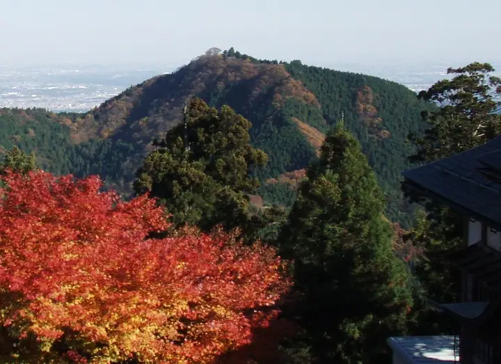
A 902 m peak straddling Ome City and Hinode Town in western Tokyo, set on the ridge that runs east from Mt. Mitake. Its summit gives sweeping views of the Kanto Plain and central Tokyo — on clear days even Tokyo Skytree and Mt. Tsukuba — making it a popular spot for greeting the New Year sunrise. It lies on the Kantō Fureai-no-Michi long-distance trail and appears in the Nihon Hyaku Mei-zan of low mountains and many Tokyo-area mountain lists.
Mt. Hinode at a glance
- Weather: The most settled day in the next 7 days is Wed, November 4: cloudy, gusts up to 4 m/s.
- Route: The shortest is Mount Mitake–Mount Hinode to Tsurutsuru Onsen Hiking Course: about 2 h 59 min, 7.0 km, about 260 m of climbing.
Mt. Hinode weather (hourly, 14 days)
Sunrise today 06:07, sunset 16:47
| Tue, 11/3 | Wed, 11/4 | Thu, 11/5 | Fri, 11/6 | Sat, 11/7 | Sun, 11/8 | Mon, 11/9 | Tue, 11/10 | Wed, 11/11 | Thu, 11/12 | Fri, 11/13 | Sat, 11/14 | Sun, 11/15 | Mon, 11/16 | Tue, 11/17 | |||||||||||||||||||||||||||||||||||||||||||||||||||||||||||||||||||||||
|---|---|---|---|---|---|---|---|---|---|---|---|---|---|---|---|---|---|---|---|---|---|---|---|---|---|---|---|---|---|---|---|---|---|---|---|---|---|---|---|---|---|---|---|---|---|---|---|---|---|---|---|---|---|---|---|---|---|---|---|---|---|---|---|---|---|---|---|---|---|---|---|---|---|---|---|---|---|---|---|---|---|---|---|---|---|
| Japan time | 15 | 17 | 19 | 21 | 23 | 1 | 3 | 5 | 7 | 9 | 11 | 13 | 15 | 18 | 21 | 0 | 3 | 6 | 9 | 12 | 15 | 18 | 21 | 0 | 3 | 6 | 9 | 12 | 15 | 18 | 21 | 0 | 3 | 6 | 9 | 12 | 15 | 18 | 21 | 0 | 3 | 6 | 9 | 12 | 15 | 18 | 21 | 0 | 3 | 6 | 9 | 15 | 21 | 3 | 9 | 15 | 21 | 3 | 9 | 15 | 21 | 3 | 9 | 15 | 21 | 3 | 9 | 15 | 21 | 3 | 9 | 15 | 21 | 3 | 9 | 15 | 21 | 3 | 9 | 15 | 21 | 3 | 9 | 15 | |
  |   |   | | | | |   |   | | |   | | | | | | | |   | |   |   |  | | |  | | | | | | | | | | | | | | | | | | | | | | | | | | | | | | | | | |   |  | |   | | | | | | | | | | | | | | | |   | | | | | ||
| Temperature | °C | 12° | 11° | 10° | 10° | 9° | 8° | 8° | 8° | 8° | 8° | 9° | 9° | 8° | 8° | 8° | 8° | 8° | 9° | 12° | 17° | 13° | 11° | 10° | 9° | 8° | 8° | 15° | 18° | 17° | 12° | 9° | 8° | 8° | 6° | 11° | 12° | 11° | 7° | 5° | 4° | 3° | 2° | 10° | 11° | 10° | 8° | 7° | 6° | 6° | 5° | 6° | 8° | 6° | 5° | 6° | 8° | 5° | 2° | 9° | 10° | 1° | -1° | 7° | 7° | 6° | 2° | 11° | 11° | 1° | 1° | 5° | 7° | 2° | 2° | 9° | 10° | 9° | 8° | 14° | 17° | 7° | 6° | 4° | 6° |
| Precipitation | mm | 0.1 | 1.1 | 1.0 | 0.4 | 0.2 | 0.3 | 1.3 | 6 | 13 | 13 | 3.4 | 0.7 | 3.1 | 0.4 | 0.5 | 0.4 | 2.7 | 13 | 0.5 | |||||||||||||||||||||||||||||||||||||||||||||||||||||||||||||||||
| New snow | cm | ||||||||||||||||||||||||||||||||||||||||||||||||||||||||||||||||||||||||||||||||||||
| Snow depth | cm | 0 | 0 | 0 | 0 | 0 | 0 | 0 | 0 | 0 | 0 | 0 | 0 | 0 | 0 | 0 | 0 | 0 | 0 | 0 | 0 | 0 | 0 | 0 | 0 | 0 | 0 | 0 | 0 | 0 | 0 | 0 | 0 | 0 | 0 | 0 | 0 | 0 | 0 | 0 | 0 | 0 | 0 | 0 | 0 | 0 | 0 | 0 | 0 | 0 | 0 | 0 | 0 | 0 | 0 | 0 | 0 | 0 | 0 | 0 | 0 | 0 | 0 | 0 | 0 | 0 | 0 | 0 | 0 | 0 | 0 | 0 | 0 | 0 | 0 | 0 | 0 | 0 | 0 | 0 | 0 | 0 | 0 | 0 | 0 |
| Wind | m/s | 2 | 0 | 0 | 0 | 0 | 0 | 0 | 0 | 1 | 1 | 1 | 1 | 0 | 1 | 1 | 1 | 3 | 2 | 2 | 2 | 2 | 1 | 0 | 0 | 1 | 1 | 0 | 3 | 2 | 1 | 1 | 1 | 0 | 0 | 2 | 3 | 3 | 1 | 1 | 1 | 1 | 1 | 1 | 3 | 2 | 0 | 1 | 0 | 1 | 1 | 1 | 2 | 1 | 2 | 1 | 2 | 1 | 2 | 5 | 4 | 2 | 1 | 1 | 2 | 1 | 1 | 0 | 4 | 1 | 0 | 1 | 2 | 1 | 0 | 1 | 1 | 0 | 1 | 0 | 4 | 2 | 1 | 1 | 2 |
| Wind gusts | m/s | 5 | 5 | 1 | 1 | 1 | 2 | 2 | 1 | 3 | 4 | 4 | 4 | 4 | 2 | 3 | 4 | 6 | 6 | 7 | 7 | 6 | 5 | 2 | 2 | 2 | 3 | 3 | 8 | 8 | 5 | 4 | 4 | 3 | 2 | 5 | 8 | 9 | 7 | 3 | 3 | 3 | 4 | 4 | 9 | 9 | 5 | 2 | 3 | 2 | 2 | 4 | 7 | 5 | 4 | 5 | 7 | 6 | 4 | 13 | 18 | 10 | 6 | 5 | 9 | 5 | 3 | 5 | 11 | 9 | 3 | 5 | 7 | 6 | 2 | 4 | 7 | 4 | 4 | 4 | 11 | 15 | 5 | 4 | 7 |
| Wind dir. | ↓ | ↓ | ↓ | ↓ | ↓ | ↓ | ↓ | ↓ | ↓ | ↓ | ↓ | ↓ | ↓ | ↓ | ↓ | ↓ | ↓ | ↓ | ↓ | ↓ | ↓ | ↓ | ↓ | ↓ | ↓ | ↓ | ↓ | ↓ | ↓ | ↓ | ↓ | ↓ | ↓ | ↓ | ↓ | ↓ | ↓ | ↓ | ↓ | ↓ | ↓ | ↓ | ↓ | ↓ | ↓ | ↓ | ↓ | ↓ | ↓ | ↓ | ↓ | ↓ | ↓ | ↓ | ↓ | ↓ | ↓ | ↓ | ↓ | ↓ | ↓ | ↓ | ↓ | ↓ | ↓ | ↓ | ↓ | ↓ | ↓ | ↓ | ↓ | ↓ | ↓ | ↓ | ↓ | ↓ | ↓ | ↓ | ↓ | ↓ | ↓ | ↓ | ↓ | ↓ | |
Mt. Hinode hiking routes
- Mount Mitake–Mount Hinode to Tsurutsuru Onsen Hiking Course 7.0 km · Ascent 258 m Mount Mitake (Station), 御岳平駅 (Aerialway station), 大展望台駅 (Aerialway station) → つるつる温泉 (Bus stop), 生涯青春の湯;つるつる温泉, つるつる温泉駐車場 第三, つるつる温泉駐車場 第二 (parking)
- Mount Hinode Return by the Old Trail from Matsuo in Hinode via Agokake Rock 6.5 km · Ascent 570 m 日の出山登山口 (Bus stop), 松尾 (Bus stop)
Hiking times are estimates calculated from the terrain.
Huts, campsites and lodging near Mt. Hinode
Mountain huts
- Shinonome-sanso
Campsites
- 大岳鍾乳洞 大岳キャンプ場
- Kawai Campsite
- 奥多摩福音の家
- 煉瓦堂朱とんぼ
- アメリカキャンプ村
Lodging
- 山楽荘
- Nanzanso
- Hojukaku
- Machikubota
- Komadori Sanso
Lists that include Mt. Hinode
Mt. Hinode facts
- Elevation
- 902 m
- Location
- Ōme, Tokyo / Hinode, Tokyo
35.781239, 139.167472 - Website
- www.town.hinode.tokyo.jp
- Trail Map
- www.town.hinode.tokyo.jp (PDF)
- Wikipedia
- ja.wikipedia.org