
Mount Ōdake
大岳山
Hinohara, Tokyo · Elevation 1,267 m
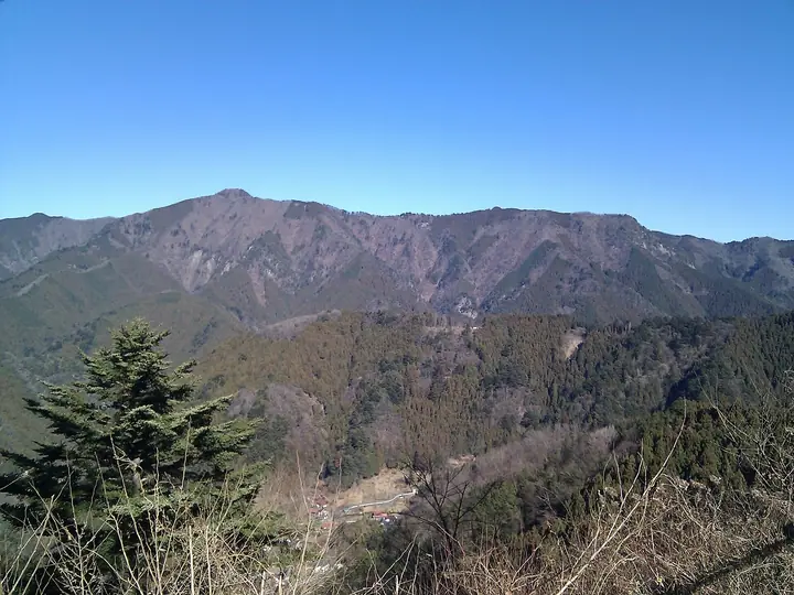
Mount Ōdake is a 1,266.5 m peak on the border between Okutama Town and Hinohara Village in Tokyo's Nishitama District, and one of the Okutama Three Mountains alongside Mount Gozen and Mount Mitō. Within the Chichibu-Tama-Kai National Park, it is included in the Nihon Nihyaku Meizan, the Hana no Hyakumeizan, the Kantō Hyakumeizan, and the Nihon Hyaku-teizan (100 Low Mountains). The summit's distinctive rocky face has long made it a focus of mountain worship; Ōtake Shrine sits just below the top. Multiple trails climb the peak—the most popular ascends from the Mitake-san Cable Car Station via Mount Nabewari and Akuba Pass, while the Sawori-one route from Okutama Station and the Unazawa Tanshō-ro waterfall route offer alternatives. From the summit climbers look out over Mount Fuji and the Okutama and Daibosatsu ranges. The mountain can be climbed year-round.
Mount Ōdake at a glance
- Weather: The most settled day in the next 7 days is Wed, November 4: cloudy, gusts up to 4 m/s.
- Route: The shortest is Mount Odake, Mount Nabewari and Okunoin Peak Loop from Mount Mitake: about 5 h 33 min, 10.4 km, about 930 m of climbing.
Mount Ōdake weather (hourly, 14 days)
Sunrise today 06:07, sunset 16:47
| Tue, 11/3 | Wed, 11/4 | Thu, 11/5 | Fri, 11/6 | Sat, 11/7 | Sun, 11/8 | Mon, 11/9 | Tue, 11/10 | Wed, 11/11 | Thu, 11/12 | Fri, 11/13 | Sat, 11/14 | Sun, 11/15 | Mon, 11/16 | Tue, 11/17 | |||||||||||||||||||||||||||||||||||||||||||||||||||||||||||||||||||||||
|---|---|---|---|---|---|---|---|---|---|---|---|---|---|---|---|---|---|---|---|---|---|---|---|---|---|---|---|---|---|---|---|---|---|---|---|---|---|---|---|---|---|---|---|---|---|---|---|---|---|---|---|---|---|---|---|---|---|---|---|---|---|---|---|---|---|---|---|---|---|---|---|---|---|---|---|---|---|---|---|---|---|---|---|---|---|
| Japan time | 15 | 17 | 19 | 21 | 23 | 1 | 3 | 5 | 7 | 9 | 11 | 13 | 15 | 18 | 21 | 0 | 3 | 6 | 9 | 12 | 15 | 18 | 21 | 0 | 3 | 6 | 9 | 12 | 15 | 18 | 21 | 0 | 3 | 6 | 9 | 12 | 15 | 18 | 21 | 0 | 3 | 6 | 9 | 12 | 15 | 18 | 21 | 0 | 3 | 6 | 9 | 15 | 21 | 3 | 9 | 15 | 21 | 3 | 9 | 15 | 21 | 3 | 9 | 15 | 21 | 3 | 9 | 15 | 21 | 3 | 9 | 15 | 21 | 3 | 9 | 15 | 21 | 3 | 9 | 15 | 21 | 3 | 9 | 15 | |
  |   |   | | | | |   |   | | |   | | | | | | | |   | |   |   |  | | |  | | | | | | | | | | | | | | | | | | | | | | | | | | | | | | | | | |   |  | |   | | | | | | | | | | | | | | | |   | | | | | ||
| Temperature | °C | 10° | 8° | 7° | 7° | 7° | 6° | 6° | 6° | 6° | 6° | 7° | 7° | 6° | 5° | 6° | 6° | 6° | 6° | 9° | 15° | 11° | 9° | 8° | 7° | 6° | 5° | 12° | 16° | 14° | 9° | 7° | 6° | 5° | 4° | 9° | 10° | 8° | 4° | 2° | 2° | 1° | 0° | 7° | 9° | 8° | 5° | 5° | 4° | 3° | 3° | 4° | 6° | 4° | 2° | 4° | 5° | 2° | 0° | 7° | 8° | -1° | -3° | 5° | 5° | 4° | 0° | 8° | 9° | -2° | -1° | 3° | 5° | 0° | -1° | 6° | 8° | 6° | 6° | 12° | 15° | 5° | 4° | 2° | 4° |
| Precipitation | mm | 0.1 | 1.1 | 1.0 | 0.4 | 0.2 | 0.3 | 1.3 | 6 | 13 | 13 | 3.4 | 0.7 | 3.1 | 0.4 | 0.5 | 0.4 | 2.7 | 13 | 0.5 | |||||||||||||||||||||||||||||||||||||||||||||||||||||||||||||||||
| New snow | cm | ||||||||||||||||||||||||||||||||||||||||||||||||||||||||||||||||||||||||||||||||||||
| Snow depth | cm | 0 | 0 | 0 | 0 | 0 | 0 | 0 | 0 | 0 | 0 | 0 | 0 | 0 | 0 | 0 | 0 | 0 | 0 | 0 | 0 | 0 | 0 | 0 | 0 | 0 | 0 | 0 | 0 | 0 | 0 | 0 | 0 | 0 | 0 | 0 | 0 | 0 | 0 | 0 | 0 | 0 | 0 | 0 | 0 | 0 | 0 | 0 | 0 | 0 | 0 | 0 | 0 | 0 | 0 | 0 | 0 | 0 | 0 | 0 | 0 | 0 | 0 | 0 | 0 | 0 | 0 | 0 | 0 | 0 | 0 | 0 | 0 | 0 | 0 | 0 | 0 | 0 | 0 | 0 | 0 | 0 | 0 | 0 | 0 |
| Wind | m/s | 2 | 0 | 0 | 0 | 0 | 0 | 0 | 0 | 1 | 1 | 1 | 1 | 0 | 1 | 1 | 1 | 3 | 2 | 2 | 2 | 2 | 1 | 0 | 0 | 1 | 1 | 0 | 3 | 2 | 1 | 1 | 1 | 0 | 0 | 2 | 3 | 3 | 1 | 1 | 1 | 1 | 1 | 1 | 3 | 2 | 0 | 1 | 0 | 1 | 1 | 1 | 2 | 1 | 2 | 1 | 2 | 1 | 2 | 5 | 4 | 2 | 1 | 1 | 2 | 1 | 1 | 0 | 4 | 1 | 0 | 1 | 2 | 1 | 0 | 1 | 1 | 0 | 1 | 0 | 4 | 2 | 1 | 1 | 2 |
| Wind gusts | m/s | 5 | 5 | 1 | 1 | 1 | 2 | 2 | 1 | 3 | 4 | 4 | 4 | 4 | 2 | 3 | 4 | 6 | 6 | 7 | 7 | 6 | 5 | 2 | 2 | 2 | 3 | 3 | 8 | 8 | 5 | 4 | 4 | 3 | 2 | 5 | 8 | 9 | 7 | 3 | 3 | 3 | 4 | 4 | 9 | 9 | 5 | 2 | 3 | 2 | 2 | 4 | 7 | 5 | 4 | 5 | 7 | 6 | 4 | 13 | 18 | 10 | 6 | 5 | 9 | 5 | 3 | 5 | 11 | 9 | 3 | 5 | 7 | 6 | 2 | 4 | 7 | 4 | 4 | 4 | 11 | 15 | 5 | 4 | 7 |
| Wind dir. | ↓ | ↓ | ↓ | ↓ | ↓ | ↓ | ↓ | ↓ | ↓ | ↓ | ↓ | ↓ | ↓ | ↓ | ↓ | ↓ | ↓ | ↓ | ↓ | ↓ | ↓ | ↓ | ↓ | ↓ | ↓ | ↓ | ↓ | ↓ | ↓ | ↓ | ↓ | ↓ | ↓ | ↓ | ↓ | ↓ | ↓ | ↓ | ↓ | ↓ | ↓ | ↓ | ↓ | ↓ | ↓ | ↓ | ↓ | ↓ | ↓ | ↓ | ↓ | ↓ | ↓ | ↓ | ↓ | ↓ | ↓ | ↓ | ↓ | ↓ | ↓ | ↓ | ↓ | ↓ | ↓ | ↓ | ↓ | ↓ | ↓ | ↓ | ↓ | ↓ | ↓ | ↓ | ↓ | ↓ | ↓ | ↓ | ↓ | ↓ | ↓ | ↓ | ↓ | ↓ | |
Mount Ōdake hiking routes
- Mount Odake, Mount Nabewari and Okunoin Peak Loop from Mount Mitake 10.4 km · Ascent 935 m Mount Mitake (Station), 御岳平駅 (Aerialway station), 大展望台駅 (Aerialway station)
- Mount Odake and Mount Nokogiri Traverse from Mitake to Okutama 12.1 km · Ascent 875 m Mount Mitake (Station), 御岳平駅 (Aerialway station), 大展望台駅 (Aerialway station) → Okutama Station (Bus stop), Oku-Tama (Station), 南一丁目 (Bus stop), 下栃久保 (Bus stop), Times
- Okutama–Mitake Traverse via Nokogiriyama and Odakesan 12.2 km · Ascent 1,464 m Okutama Station (Bus stop), Oku-Tama (Station), 南一丁目 (Bus stop), 下栃久保 (Bus stop), Times → Mount Mitake (Station), 御岳平駅 (Aerialway station), 大展望台駅 (Aerialway station)
- Mount Mitake and Mount Odake Out-and-Back from Mitake Station 22.5 km · Ascent 1,529 m 御嶽駅 (Station), Mitake (Station), Mitake Station (Bus stop), 御岳駅バス停 (Bus stop)
Hiking times are estimates calculated from the terrain.
Huts, campsites and lodging near Mount Ōdake
Mountain huts
- Shinonome-sanso
- 御前山避難小屋 unstaffed
Campsites
- 大岳鍾乳洞 大岳キャンプ場
- アメリカキャンプ村
Lodging
- Komadori Sanso
- Hojukaku
- Machikubota
- Kuraya
- Machiya
Lists that include Mount Ōdake
Japan 200 Famous Mountains · Japan's 300 Famous Mountains · 100 Famous Mountains of Flowers · 100 Low Mountains of Japan · Kanto 100 Famous Mountains · 100 Mountains of Tama · 3 Mountains of Okutama · Elevations of 1003 Mountains of Japan · 1000 Mountains of Japan
Mount Ōdake facts
- Elevation
- 1,267 m
- Location
- Hinohara, Tokyo
35.765197, 139.130366 - National Park
- 秩父多摩甲斐国立公園
- Website
- www.town.okutama.tokyo.jp
- Trail Map
- www.kankyo1.metro.tokyo.lg.jp (PDF)
- Access Information
- hinohara-kankou.jp
- Wikipedia
- ja.wikipedia.org